Black Warrior River
- This page is about the river. For the water park ride, see Splash Adventure.
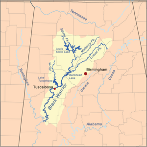
The Black Warrior River, in west-central Alabama, is a 293-mile long tributary of the Tombigbee River. The river is navigable along its entire course, forming part of the extended system of waterways that link Mobile Bay to freight facilities at Port Birmingham. It is named for the Choctaw chief Tascaluza, whose name translates as "black warrior".
Like the Cahaba River, the Black Warrior's entire watershed lies entirely within Alabama. It covers 6,276 square miles, or just over 12 percent of the state. It is separated from the Cahaba watershed by Red Mountain.
The Black Warrior River watershed is the largest river system entirely contained within Alabama, America's leading state for freshwater biodiversity. Black Warrior Riverkeeper, a non-profit organization and member of Waterkeeper Alliance, patrols the Black Warrior River and its tributaries for pollution.
Upper Black Warrior Watershed
The river is formed approximately 25 miles west of Birmingham by the confluence of the Sipsey, Mulberry and Locust forks, which join as arms of Bankhead Lake.
The upper Black Warrior once flowed across numerous rocky shoals, including the extensive Squaw Shoals. But the need for reservoirs, hydroelectric power, and navigable river courses led to its impoundment in a series of narrow lakes separated by locks and dams.
The Birmingham Water Works taps the river at the upper end of Bankhead Lake. Over 600 permitted dischargers add wastewater and runoff to the lake downstream of the water works inlet.
Tributaries in this section are generally low gradient, habitat poor, glide/pool streams flowing through forested land and fed year-round by aquifers. The area includes the Southwestern terminus of the Appalachian Mountain chain and the Cumberland Plateau. The Warrior Coal Fields, located in the plateau, holds Alabama's richest coal deposits.
Bankhead Lake and Holt Lake, formed by the Holt Lock and Dam, encompass the entire course of the river for its uppermost 50 miles, stretching southeast into central Tuscaloosa County, northwest of Tuscaloosa. The North River joins the Black Warrior at Lake Tuscaloosa.
Lower Black Warrior Watershed
The Black Warrior flows westward past downtown Tuscaloosa, the largest city on the river, then flows generally south in a highly meandering course, impounded for nine miles by the Oliver Lock and Dam, forming Oliver Lake. The Bama Belle is docked in the section of river near downtown Tuscaloosa. The section south of Tuscaloosa, below the fall line, is the "Lower Black Warrior Watershed".
The tributaries in the lower section of the river drain the Blackland Prairie and Flatwoods/Alluvial Prairie Margin regions of the Black Belt. These streams typically cut through the thick loamy-clay soil, revealing chalky bedrock. Fed mostly by runoff, these streams, flowing through deciduous and piney woods, as well as bluestem prairie, are highly variable and often dry in summer.
The last 30 miles of the river are part of the narrow Lake Demopolis. The river flows into the Tombigbee from the northeast near the city of Demopolis in northern Marengo County.
Endangered Species
The following endangered or threatened species have been found in the Black Warrior River Basin:
- Alabama Moccasinshell Mussel
- Alabama Streak Sorus Fern
- Bald eagle
- Cahaba Shiner
- Coosa Moccasinshell Mussel
- Dark Pigtoe Pearly Mussel
- Eggert's Sunflower
- Fine-lined Pocketbook Mussel
- Flat Pigtoe Mussel
- Flattened Musk Turtle
- Gray Bat
- Heavy Pigtoe Mussel
- Indiana Bat
- Inflated Heelsplitter Mussel
- Kral's Water Plantain
- Leafy-Prarie Clover
- Orange-nacre Mucket Mussel
- Ovate Clubshell Mussel
- Plicate Rocksnail
- Red-cockaded Woodpecker
- Southern Clubshell Mussel
- Stirrupshell Mussel
- Triangular Kidneyshell Mussel
- Upland Combshell Mussel
- Vermilion Darter
- Watercress Darter
- Wood Stork
- Warrior darter
- Warrior shiner
References
- "Black Warrior River." Wikipedia, The Free Encyclopedia. 17 Sep 2006, 14:18 UTC. Wikimedia Foundation, Inc. 17 Sep 2006 [1].
External links
- Description at riversofalabama.org
- Black Warrior Clean Water Partnership
- Black Warrior Riverkeeper
| Black Warrior River | |
|---|---|
| Dams |
Bankhead Lock and Dam, Holt Lock and Dam, Oliver Lock and Dam, Lewis Smith Dam, Warrior Lock and Dam |
| Reservoirs |
Bankhead Lake, Holt Lake, Lake Tuscaloosa, Lake Oliver, Smith Lake, Inland Lake, Highland Lake, Warrior Lake |
| Tributaries |
Blackburn Fork, Locust Fork, Mulberry Fork, North River, Sipsey Fork, Valley Creek, Village Creek |
| Dual licensed with the Creative Commons Attribution Share-Alike License version 3.0 | |
| This article is published under the GFDL and the Creative Commons Attribution Share-Alike license v3.0. | |
