File:Mississippi Territory dark.gif
Jump to navigation
Jump to search

No higher resolution available.
Mississippi_Territory_dark.gif (480 × 431 pixels, file size: 16 KB, MIME type: image/gif)
Downloaded from Wikimedia Commons.
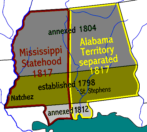
Stylized map of the Mississippi Territory, showing changes from establishment in 1798, with area annexed in 1804 after the Louisiana Purchase, plus the area annexed after the War of 1812, and the 1817 division for Mississippi statehood creating the Alabama Territory (statehood in 1819).
| This work is in the public domain | |
| This work has been released by its creator into the public domain. | |
File history
Click on a date/time to view the file as it appeared at that time.
| Date/Time | Thumbnail | Dimensions | User | Comment | |
|---|---|---|---|---|---|
| current | 17:08, 16 May 2011 | | 480 × 431 (16 KB) | Lkseitz (talk | contribs) | Downloaded from [http://commons.wikimedia.org/wiki/File:Mississippi_Territory_dark.gif Wikimedia Commons]. Stylized map of the Mississippi Territory, showing changes from establishment in 1798, with area annexed in 1804 after the Louisiana Purchase, plus |
You cannot overwrite this file.
File usage
The following page uses this file: