Ashville
| City of Ashville | |
| Incorporated | 1822 |
|---|---|
| Population | 2,255 |
| Mayor | Robert McKay |
| School district | St Clair County Schools |
| Government |
Ashville City Council |
| Web site | |

| |
| Locate with Google Maps | |
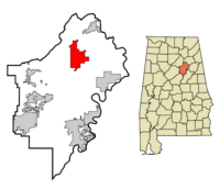
Ashville is a city of 2,255 and one of the seats of St Clair County. It covers 19.4 square miles in the northern half of the county. The town was first known as St Clairsville before being incorporated as Ashville in 1822. The name honors state assemblyman John Ashe, who served on the commission that established the St Clair County Courthouse in the town a year earlier. The courthouse was rebuilt in 1844.
In 1907 Pell City, separated by Backbone Mountain, took over the administration of justice in the southern half of the county.
U. S. Highway 11 runs through Ashville between Attalla and Springville.
Government
The city of Ashville is governed by a Mayor and 5-member City Council, which meets on the first and third Monday of each month at Ashville City Hall at 211 8th Street. The current mayor is Robert McKay. Former mayors include Joe Adkins (1970).
City Council
- Place 1: David Thompson
- Place 2: Michael Byers
- Place 3: Bobby Bowlin
- Place 4: Willie Turner
- Place 5: Ronnie White
The Ashville Police Department is headed by Chief Dennis Matthews. The Ashville Fire Department is overseen by Chief Mike Barry. The city also operates departments of streets, water & sewer, parks & recreation, and planning & zoning. The Ashville Municipal Court and the Ashville Public Library also come under city control. The St Clair County Jail is split between the two county seats, with juvenile offenders held in Ashville.
Demographics
As of the census of 2000, there were 2,260 people, 814 households, and 608 families residing in the town. The population density was 116.9 people per square mile. There were 905 housing units at an average density of 46.8/sq mi. The racial makeup of the town was 69% White and 27% African American. 3% of the population were Hispanic or Latino of any race.
There were 814 households out of which 37% had children under the age of 18 living with them, 57% were married couples living together, 14% had a female householder with no husband present, and 25% were non-families. 23% of all households were made up of individuals and 11% had someone living alone who was 65 years of age or older. The average household size was 2.64 and the average family size was 3.10.
In the town the population was spread out with 26% under the age of 18, 9% from 18 to 24, 28% from 25 to 44, 23% from 45 to 64, and 14% who were 65 years of age or older. The median age was 36 years. For every 100 females there were 102.3 males. For every 100 females age 18 and over, there were 100.1 males.
The median income for a household in the town was $31,509, and the median income for a family was $38,355. Males had a median income of $31,081 versus $21,914 for females. The per capita income for the town was $15,867. About 11% of families and 15% of the population were below the poverty line, including 14% of those under age 18 and 18% of those age 65 or over.
Education
Ashville's grade school students attend St Clair County Schools. Schools in the city include Ashville Elementary School, Ashville Middle School, and Ashville High School.
Landmarks
Besides the St Clair County Courthouse, notable landmarks in Ashville include the John Looney House (site of the St Clair County Fall Festival), and the meeting house of Ashville Lodge No. 186.
References
- Foscue, Virginia O. (1989) Place Names in Alabama. Tuscaloosa: University of Alabama Press. ISBN 081730410X
- "Ashville, Alabama" (January 28, 2009) Wikipedia - accessed March 13, 2009
| St Clair County | |
|---|---|
| Topics | |
| Cities |
Argo | Ashville (seat) | Leeds | Margaret | Moody | Odenville | Pell City (seat) | Ragland | Riverside | Springville | Steele | Trussville | Vincent |