Blountsville
| Town of Blountsville | |
| Incorporated | 1827 |
|---|---|
| Population | 1,698 |
| Mayor | Mike Glass |
| School district | Blount County Schools |
| Government |
Blountsville Town Council |
| Web site | none |

| |
| Locate with Google Maps | |
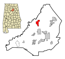
Blountsville is a Class 8 town of 1,698 on 5.4 square miles in northwestern Blount County at the junction of Blount County Highway 26 and U.S. Highway 231, and is also accessed from Alabama Highway 79. The mayor is Mike Glass.
The location was first used as a trading post on the Huntsville Road and Black Warrior Road, near the border between Creek and Cherokee territory. It appears sometimes as Wasaasa and became more commonly known as Bear Meat Cabin.
Caleb Fryley and John Jones, the area's first "legitimate" white settlers, arrived at Bear Meat Cabin by wagon in 1816. Jones continued onward and founded Jonesborough. Fryley established his household nearby and instituted a blacksmithing forge at the trading post. Blountsville Methodist Church was founded by missionary Ebenezer Hearn in 1818.
By then the district became populous enough for the Alabama Territorial Legislature to create a county. John Gilbraith, William Reno, Stephen Box, Moses Burleson and Henry McPherson were appointed commissioners and charged with selecting a county seat. They chose Bear Meat Cabin, which was renamed "Blountsville" when the county was officially created in December 1820. Blountsville was incorporated on December 13, 1827 and erected a large new courthouse building in 1833.
Blountsville Academy (later Blount College) was established in the thriving town in the 1850s. During the Civil War Blountsville was the site of a Confederate horse stable and cavalry depot used by General Nathan Bedford Forrest. Union Colonel Abel Streight raided the town on May 1, 1863 before Forrest's cavalry ran them off. Later the town was occupied by Union forces under Lovell Rousseu in June 1864.
Blountsville's importance faded after the County Courthouse was moved to Oneonta in 1889 and the Central Alabama Agricultural School closed in the early 20th century. The town has preserved several of its early structures, including the 1818 Methodist church, the Freeman residence (1825), Hendrick's Tavern (Barclift Inn, 1834), the Thomas Nation residence (1825, in ruins) Copeland-Bussey residence (1835), the Warren residence (1850s). The Freeman residence is a centerpiece of Blountsville Historical Park, which hosts the annual Blountsville Heritage Festival with a re-enactment of Streight's Raid.
Blountsville grade school students attend Blountsville Elementary School and J. B. Pennington High School, both in the Blount County Schools system. The first Blountsville Public Library was founded by Byron Pass in his home. It moved to the Methodist church's bell tower in 1954 before the town built a library building in 1960. The present Blountsville Public Library was built on Chestnut Street in 1997.
Spring Valley Beach Water Park is Blountsville's major visitor attraction.
Notable residents
- American Front skinhead group
- Doyle Gibbs, Mayor of Blountsville (1970)
- Lonnie Noojin, Central Alabama Agricultural School football coach
- Eddie Priest, baseball pitcher
- Jesse Thomason, basket weaver
Demographics
According to the 2010 census, Blountsville's population was 1,684, of which 87.3% were White and 15.3% Hispanic or Latino of any race. Median household income was $25,238 and per capita income was $15,372. 31.6% of workers in Blountsville were employed in manufacturing; with 15.5% in construction; 13.5% in retail; 8.2% in wholesale trade; 8.0% providing medical, social or educational services; 4.8% involved in finance, insurance or real estate; and 4.4% in arts, recreation or hospitality.
As of the census of 2000, there were 1,768 people, 743 households, and 479 families residing in the town. The population density was 326.4 people per square mile. There were 853 housing units at an average density of 157.5 per square mile. The racial makeup of the town was 90% White. 16% of the population were Hispanic or Latino of any race.
There were 743 households out of which 29.7% had children under the age of 18 living with them, 47.8% were married couples living together, 12.0% had a female householder with no husband present, and 35.5% were non-families. 31.2% of all households were made up of individuals and 16.7% had someone living alone who was 65 years of age or older. The average household size was 2.38 and the average family size was 2.97.
In the town the population was spread out with 24.8% under the age of 18, 9.8% from 18 to 24, 27.0% from 25 to 44, 21.9% from 45 to 64, and 16.5% who were 65 years of age or older. The median age was 37 years. For every 100 females there were 95.4 males. For every 100 females age 18 and over, there were 88.2 males.
The median income for a household in the town was $24,432, and the median income for a family was $34,050. Males had a median income of $27,874 versus $18,869 for females. The per capita income for the town was $13,426. About 19.3% of families and 25.5% of the population were below the poverty line, including 30.4% of those under age 18 and 28.8% of those age 65 or over.
References
- Davis, Robert S. (1999) A Blountsville Picture Book. Blountsville: Blountsville Historical Society
- Blount County Heritage Book Committee (1999) The Heritage of Blount County, Alabama. Clanton: Heritage Publishing Consultants
- Wison, Claire M. (December 5, 2012) "Blountsville". Encyclopedia of Alabama - accessed April 21, 2014
- "Blountsville, Alabama" (October 4, 2013) Wikipedia - accessed April 21, 2014
- Gholson, Ron (April 15, 2015) "A short history of Wassausey: Blountsville: town with an energetic past" The Blount Countian
| Blount County | |
|---|---|
| Topics | |
| Cities and Towns |
Allgood | Altoona | Blountsville | Cleveland | County Line | Garden City | Hayden | Highland Lake | Locust Fork | Nectar | Oneonta (seat) | Rosa | Snead | Susan Moore | Warrior |