File:1819 Black Warrior Town map.jpg: Difference between revisions
Jump to navigation
Jump to search
(Detail from a "Map of Alabama constructed from the surveys in the General Land Office and other documents. Improved to 1819," by John Melish, published in Philadelphia in 1819. From the Library of Congress ([https://lccn.loc.gov/gm71005414 link])) |
No edit summary |
||
| Line 1: | Line 1: | ||
Detail from a "Map of Alabama constructed from the surveys in the General Land Office and other documents. Improved to 1819," by John Melish, published in Philadelphia in 1819. From the Library of Congress ([https:// | Detail from a "Map of Alabama constructed from the surveys in the General Land Office and other documents. Improved to 1819," by John Melish, published in Philadelphia in 1819. From the Library of Congress ([https://www.loc.gov/resource/g3970.ct007144/ link]) | ||
Latest revision as of 13:24, 23 August 2019
Detail from a "Map of Alabama constructed from the surveys in the General Land Office and other documents. Improved to 1819," by John Melish, published in Philadelphia in 1819. From the Library of Congress (link)
File history
Click on a date/time to view the file as it appeared at that time.
| Date/Time | Thumbnail | Dimensions | User | Comment | |
|---|---|---|---|---|---|
| current | 11:45, 23 August 2019 | 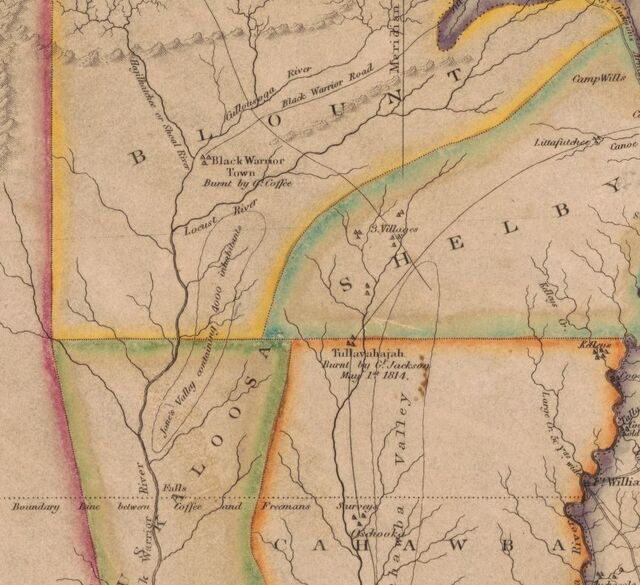 | 640 × 585 (81 KB) | Dystopos (talk | contribs) | Detail from a "Map of Alabama constructed from the surveys in the General Land Office and other documents. Improved to 1819," by John Melish, published in Philadelphia in 1819. From the Library of Congress ([https://lccn.loc.gov/gm71005414 link]) |
You cannot overwrite this file.
File usage
The following page uses this file: