File:Center Point Pkwy after tornado.jpg: Difference between revisions
Jump to navigation
Jump to search
(''Birmingham News'' aerial photo of damage from the January 2012 tornado outbreak on Center Point Parkway at 24th Avenue Northwest ([http://maps.google.com/maps&hl=en&ll=33.648844,-86.683111&spn=0.002491,0.001124&t=h&z=19 map]) {{Fair Use) |
No edit summary |
||
| Line 1: | Line 1: | ||
''[[Birmingham News]]'' aerial photo of damage from the [[January 2012 tornado outbreak]] on [[Center Point Parkway]] at [[24th Avenue Northwest]] ([http://maps.google.com/maps&hl=en&ll=33. | ''[[Birmingham News]]'' aerial photo of damage from the [[January 2012 tornado outbreak]] on [[Center Point Parkway]] at [[24th Avenue Northwest]] ([http://maps.google.com/maps?q=Center+Point+Parkway&hl=en&ll=33.648607,-86.683371&spn=0.002491,0.001124&safe=off&t=h&z=19 map]) | ||
{{Fair Use}} | {{Fair Use}} | ||
Latest revision as of 10:26, 26 January 2012
Birmingham News aerial photo of damage from the January 2012 tornado outbreak on Center Point Parkway at 24th Avenue Northwest (map)
| Fair Use media | |
| This work is subject to copyright and/or trade mark protection. It is used here without express permission under the legal doctrine of Fair Use. Rights to the work remain the sole property of the creator. See Bhamwiki:Copyrights for further information. | |
File history
Click on a date/time to view the file as it appeared at that time.
| Date/Time | Thumbnail | Dimensions | User | Comment | |
|---|---|---|---|---|---|
| current | 10:24, 26 January 2012 | 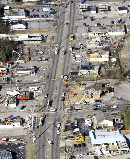 | 450 × 550 (155 KB) | Dystopos (talk | contribs) | ''Birmingham News'' aerial photo of damage from the January 2012 tornado outbreak on Center Point Parkway at 24th Avenue Northwest ([http://maps.google.com/maps&hl=en&ll=33.648844,-86.683111&spn=0.002491,0.001124&t=h&z=19 map]) {{Fair Use |
You cannot overwrite this file.
File usage
The following 3 pages use this file: