Advent Circle: Difference between revisions
No edit summary |
m (Typo) |
||
| (One intermediate revision by one other user not shown) | |||
| Line 1: | Line 1: | ||
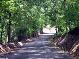
[[Image:AdventCircle.jpg|right|thumb| | [[Image:AdventCircle.jpg|right|thumb|275px|Driving to the east.]] | ||
'''Advent Circle''' is a | '''Advent Circle''' is a long-looping road in eastern [[Jefferson County]] between [[Trussville]] and [[Argo]]. The southern end is a continuation of [[Camp Mary Munger Road]] at the intersection of [[Happy Hollow Road]]. From there it crosses [[I-59]] and continues north toward [[Wynwood Lake]]. Shortly after it bends eastward it turns sharply back to the north toward [[Liles Lake]]. As soon as the Circle reaches [[Liles Lane]] it turns back southward and crosses I-59 once again near [[Hubbards Lake]]. The road ends at [[Micklewright Road]] just across [[U. S. Highway 11]]. | ||
The historic [[Massey Cemetery]] is located within the loop Advent Circle makes with I-59. | It was in this area that [[Samuel Massey]] and [[Warren Truss]] first settled in [[1819]] and [[1820]]. Truss later moved southward to the area now occupied by the city that came to bear his name. The historic [[Massey Cemetery]] is located within the loop Advent Circle makes with I-59. | ||
[[Category:Advent Circle|*]] | [[Category:Advent Circle|*]] | ||
Latest revision as of 11:13, 16 March 2009
Advent Circle is a long-looping road in eastern Jefferson County between Trussville and Argo. The southern end is a continuation of Camp Mary Munger Road at the intersection of Happy Hollow Road. From there it crosses I-59 and continues north toward Wynwood Lake. Shortly after it bends eastward it turns sharply back to the north toward Liles Lake. As soon as the Circle reaches Liles Lane it turns back southward and crosses I-59 once again near Hubbards Lake. The road ends at Micklewright Road just across U. S. Highway 11.
It was in this area that Samuel Massey and Warren Truss first settled in 1819 and 1820. Truss later moved southward to the area now occupied by the city that came to bear his name. The historic Massey Cemetery is located within the loop Advent Circle makes with I-59.
