Birmingham Medical District: Difference between revisions
No edit summary |
No edit summary |
||
| (4 intermediate revisions by 2 users not shown) | |||
| Line 1: | Line 1: | ||
[[Image:Birmingham_Medical_District_sign.jpg|right | [[Image:Birmingham_Medical_District_sign.jpg|right]] | ||
The '''Birmingham Medical District''' is an area on Birmingham's Southside that is home to various medical entities. In 2012, the [[Birmingham Design Review Committee]] approved a new way-finding sign program that consists of 35 signs at various spots between [[6th Avenue South]] and [[Railroad Park]]. | The '''Birmingham Medical District''' is an area on Birmingham's Southside that is home to various medical entities anchored by [[UAB Medical Center]]. In 2012, the [[Birmingham Design Review Committee]] approved a new way-finding sign program that consists of 35 signs at various spots between [[6th Avenue South]] and [[Railroad Park]]. | ||
The signs are installed on street-lamp poles and aid travelers in virtually every direction as they make their way to destinations such as the [[UAB Medical Center]], the [[VA Medical Center]], [[Cooper Green Mercy Hospital]], the [[Callahan Eye Foundation Hospital]], [[Kirklin Clinic]], [[UAB Highlands]], the [[Benjamin Russell Hospital for Children]] or any other major destination in the district. | The signs are installed on street-lamp poles and aid travelers in virtually every direction as they make their way to destinations such as the [[UAB Medical Center]], the [[VA Medical Center]], [[Cooper Green Mercy Hospital]], the [[Callahan Eye Foundation Hospital]], [[Kirklin Clinic]], [[UAB Highlands]], the [[Benjamin Russell Hospital for Children]] or any other major destination in the district. | ||
| Line 6: | Line 6: | ||
The way-finding system is part of an ultimate plan to help pull traffic off [[Interstate 65]] and the [[Elton B. Stephens Expressway]] directly into the medical district without making [[University Boulevard]] the default artery for all things UAB. The UAB Medical Center gets around 5,000 visitors per day and taking that traffic off University Boulevard would aid in reducing congestion. | The way-finding system is part of an ultimate plan to help pull traffic off [[Interstate 65]] and the [[Elton B. Stephens Expressway]] directly into the medical district without making [[University Boulevard]] the default artery for all things UAB. The UAB Medical Center gets around 5,000 visitors per day and taking that traffic off University Boulevard would aid in reducing congestion. | ||
An additional 16 way-finding signs that are specific to [[UAB]]'s academic campus have also been installed. Those signs carry the UAB logo at the top to distinguish them from those that guide visitors to Birmingham Medical District destinations. | An additional 16 way-finding signs that are specific to [[UAB]]'s academic campus have also been installed. Those signs carry the [[UAB logo]] at the top to distinguish them from those that guide visitors to Birmingham Medical District destinations. | ||
==References== | ==References== | ||
| Line 12: | Line 12: | ||
[[Category:Birmingham Medical District|*]] | [[Category:Birmingham Medical District|*]] | ||
[[Category:2012 establishments]] | |||
Latest revision as of 12:06, 18 October 2019
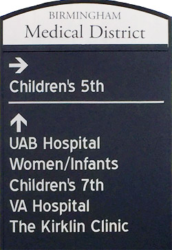
The Birmingham Medical District is an area on Birmingham's Southside that is home to various medical entities anchored by UAB Medical Center. In 2012, the Birmingham Design Review Committee approved a new way-finding sign program that consists of 35 signs at various spots between 6th Avenue South and Railroad Park.
The signs are installed on street-lamp poles and aid travelers in virtually every direction as they make their way to destinations such as the UAB Medical Center, the VA Medical Center, Cooper Green Mercy Hospital, the Callahan Eye Foundation Hospital, Kirklin Clinic, UAB Highlands, the Benjamin Russell Hospital for Children or any other major destination in the district.
The way-finding system is part of an ultimate plan to help pull traffic off Interstate 65 and the Elton B. Stephens Expressway directly into the medical district without making University Boulevard the default artery for all things UAB. The UAB Medical Center gets around 5,000 visitors per day and taking that traffic off University Boulevard would aid in reducing congestion.
An additional 16 way-finding signs that are specific to UAB's academic campus have also been installed. Those signs carry the UAB logo at the top to distinguish them from those that guide visitors to Birmingham Medical District destinations.
References
- Tomberlin, Michael (May 24, 2012) "Can't find your doc? Say 'Ah!' Way-pointing signs to guide medical district visitors" The Birmingham News
