Birminghenge: Difference between revisions
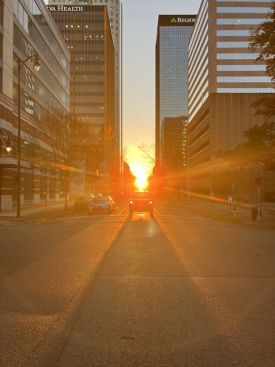
Mark Taylor (talk | contribs) (Created page with "right|thumb|Birminghenge, from the intersection of 5th Avenue North and Richard Arrington Jr Boulevard. '''Birminghenge''' is the phenomenon visible within the Birmingham city center street grid when the setting sun is precisely aligned with Birmingham's east-west avenues. Its name, coined by Bhamwiki editor Mark Taylor, pays homage to Stonehenge, the prehistoric monument in England, where sunset on the winter solstice...") |
No edit summary |
||
| Line 1: | Line 1: | ||
[[Image:Birminghenge.jpg|right|thumb|Birminghenge | [[Image:Birminghenge.jpg|right|thumb|275px|"Birminghenge" viewed from the intersection of 5th Avenue North and Richard Arrington Jr Boulevard]] | ||
'''Birminghenge''' is the | '''Birminghenge''' is a coincidence between the position of the setting sun and the [[Birmingham city center street grid]] when the setting sun is framed within the width of Birmingham's east-west avenues. | ||
Birmingham's avenues, laid out in [[1871]] by [[William Barker]], parallel the route of the [[Alabama & Chattanooga Railroad|Northeast & Southwest Railroad]], which itself generally follows the orientation of [[Jones Valley]], as defined to the south by [[Red Mountain]]. The resulting grid is rotated approximately 29-30° counterclockwise from due west, i.e. 240-241° | |||
Birmingham's avenues, laid out in | |||
By chance, this precisely with the azimuth of the sun just before it begins to set (around 4:30 PM CST) as seen from Birmingham during the period surrounding the winter solstice ([[December 21]]). | |||
The name plays on England's famed prehistoric stone circle "Stonehenge", which was constructed to mark the position of the sunrise at midsummer (behind the heel stone), and the sunset at midwinter (framed through what was once the monument's tallest trilithon, no longer standing). | |||
A similar phenomenon has been celebrated in other cities with regular downtown street grids, such as New York and Chicago, but Birmingham is unusual in that, like at Stonehenge, the coincidence occurs on the winter solstice. | |||
[[Category:Astronomy]] | [[Category:Astronomy]] | ||
[[Category:Downtown Birmingham]] | |||
Revision as of 09:47, 19 December 2023
Birminghenge is a coincidence between the position of the setting sun and the Birmingham city center street grid when the setting sun is framed within the width of Birmingham's east-west avenues.
Birmingham's avenues, laid out in 1871 by William Barker, parallel the route of the Northeast & Southwest Railroad, which itself generally follows the orientation of Jones Valley, as defined to the south by Red Mountain. The resulting grid is rotated approximately 29-30° counterclockwise from due west, i.e. 240-241°
By chance, this precisely with the azimuth of the sun just before it begins to set (around 4:30 PM CST) as seen from Birmingham during the period surrounding the winter solstice (December 21).
The name plays on England's famed prehistoric stone circle "Stonehenge", which was constructed to mark the position of the sunrise at midsummer (behind the heel stone), and the sunset at midwinter (framed through what was once the monument's tallest trilithon, no longer standing).
A similar phenomenon has been celebrated in other cities with regular downtown street grids, such as New York and Chicago, but Birmingham is unusual in that, like at Stonehenge, the coincidence occurs on the winter solstice.
