A Park System for Birmingham: Difference between revisions
No edit summary |
|||
| Line 12: | Line 12: | ||
* [http://www.bhistorical.org/publications/olmstead.html ''The Olmsted Vision: Parks for Birmingham''] at bhistorical.org | * [http://www.bhistorical.org/publications/olmstead.html ''The Olmsted Vision: Parks for Birmingham''] at bhistorical.org | ||
[[Category:Master | [[Category:Master plans|Park System for Birmingham]] | ||
[[Category:Birmingham | [[Category:Birmingham parks|Park System for Birmingham]] | ||
[[Category:Proposed | [[Category:Proposed parks|Park System for Birmingham]] | ||
[[Category:1924 works|Park System for Birmingham]] | [[Category:1924 works|Park System for Birmingham]] | ||
Latest revision as of 00:16, 5 December 2006
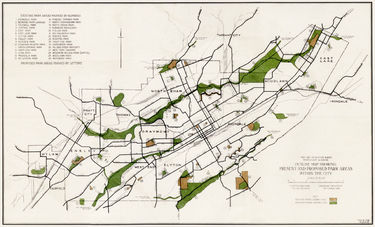
A Park System for Birmingham is a 1924 report to the City of Birmingham from the Olmsted Brothers landscape architecture firm which recommended creating a linked series of greenways and parks along waterways and mountain ridges throughout the Birmingham district. The report was published in 1925 by the Birmingham Park and Recreation Board.
Implementation of the plan was limited, as city leaders chose more often to invest in built infrastructure for recreation rather than secure green space for future parks. The decision not to prevent development of the Village Creek flood plain proved costly, as homes constructed from the 1920s on are still being bought and demolished.
The 1925 publication is the subject of the book The Olmsted Vision: Parks for Birmingham, published by the Birmingham Historical Society in 2006.
References
- Bryant, Walter (October 14, 2006) "Plan of 1925 proves evergreen." Birmingham News.
External links
- The Olmsted Vision: Parks for Birmingham at bhistorical.org
