Easley Bridge: Difference between revisions
Jump to navigation
Jump to search
No edit summary |
|||
| Line 1: | Line 1: | ||
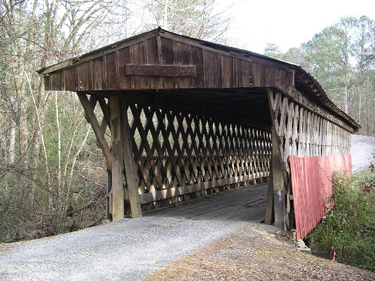
[[Image:Easley Bridge.jpg|right|thumb|375px|Easley Bridge in 2004]] | |||
The '''Easley Bridge''' (sometimes called '''Old Easley Bridge''' or '''Rosa Bridge''') is a 95 foot-long single-span covered bridge over the [[Dub branch]] of [[Calvert Prong]], which becomes [[Locust Fork River|Locust Fork]]. It is located on an unnamed road near [[Blount County Highway 33]] between the communites of [[Easley]] and [[Rosa]], and is the oldest of three remaining covered bridges in [[Blount County]]. | The '''Easley Bridge''' (sometimes called '''Old Easley Bridge''' or '''Rosa Bridge''') is a 95 foot-long single-span covered bridge over the [[Dub branch]] of [[Calvert Prong]], which becomes [[Locust Fork River|Locust Fork]]. It is located on an unnamed road near [[Blount County Highway 33]] between the communites of [[Easley]] and [[Rosa]], and is the oldest of three remaining covered bridges in [[Blount County]]. | ||
Revision as of 20:23, 2 March 2011
The Easley Bridge (sometimes called Old Easley Bridge or Rosa Bridge) is a 95 foot-long single-span covered bridge over the Dub branch of Calvert Prong, which becomes Locust Fork. It is located on an unnamed road near Blount County Highway 33 between the communites of Easley and Rosa, and is the oldest of three remaining covered bridges in Blount County.
The Easley Bridge was constructed in the "town truss" style by brothers Forrest and Zelmer Tidwell in 1927 and 1928. It stands about 18 feet above the stream bed, which is often dry.
Blount County has been working to secure funding for structural analysis and conservation of its three covered bridges and may begin accepting bids in early 2009.
References
- Prince, A. G. (1981) Alabama's Covered Bridges: Past and Present. revised edition. Ensley: Best Printing Service
- University of Alabama Center for Public Television and Radio. Bridges to the Past
