Margaret: Difference between revisions
No edit summary |
No edit summary |
||
| Line 1: | Line 1: | ||
{{Infobox City | name=Margaret | {{Infobox City | name=Margaret | ||
| year=1959 | | year=1959 | ||
| population= | | population=4,506 | ||
| mayor=Jeff Wilson | | mayor=Jeff Wilson | ||
| website=None | | website=None | ||
| Line 8: | Line 8: | ||
}} | }} | ||
'''Margaret''' is a town of about | '''Margaret''' is a town of about 4,506 in [[St Clair County]]. It was founded in [[1906]] as a coal-mining camp by the [[Alabama Fuel & Iron Company]] and named by its president, [[Charles DeBardeleben]] for his wife, [[Margaret DeBardeleben|Margaret]]. | ||
The town was incorporated in [[1959]] and held its first elections in February [[1960]], installing [[F. B. Caroll]] as its first mayor. | The town was incorporated in [[1959]] and held its first elections in February [[1960]], installing [[F. B. Caroll]] as its first mayor. | ||
Revision as of 11:58, 21 May 2015
| City of Margaret | |
| Incorporated | 1959 |
|---|---|
| Population | 4,506 |
| Mayor | Jeff Wilson |
| School district | St Clair County Schools |
| Government |
Margaret City Council |
| Web site | None |

| |
| Locate with Google Maps | |
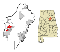
Margaret is a town of about 4,506 in St Clair County. It was founded in 1906 as a coal-mining camp by the Alabama Fuel & Iron Company and named by its president, Charles DeBardeleben for his wife, Margaret.
The town was incorporated in 1959 and held its first elections in February 1960, installing F. B. Caroll as its first mayor.
The Margaret City Council meets on the first and third Tuesday of each month at the Margaret Town Hall. The Chief of the Margaret Police Department is Michael B. Harris.
Geography
According to the U.S. Census Bureau, the town has a total area of 9.3 square miles, of which 0.21% is water.
Demographics
As of the census of 2000, there were 1,169 people, 401 households, and 326 families residing in the town. The population density was 125.8 people per square mile. There were 457 housing units at an average density of 49.2 per square mile. The racial makeup of the town was 65.2% White and 32.6% Black.
There were 401 households out of which 41.9% had children under the age of 18 living with them, 60.8% were married couples living together, 16.5% had a female householder with no husband present, and 18.7% were non-families. 16.7% of all households were made up of individuals and 4.5% had someone living alone who was 65 years of age or older. The average household size was 2.92 and the average family size was 3.26.
In the town the population was spread out with 31.7% under the age of 18, 8.3% from 18 to 24, 30.9% from 25 to 44, 22.3% from 45 to 64, and 6.8% who were 65 years of age or older. The median age was 31 years. For every 100 females there were 92.6 males. For every 100 females age 18 and over, there were 90.0 males.
The median income for a household in the town was $30,147, and the median income for a family was $32,019. Males had a median income of $28,798 versus $16,855 for females. The per capita income for the town was $13,764. About 14.0% of families and 15.9% of the population were below the poverty line, including 16.9% of those under age 18 and 13.1% of those age 65 or over.
Landmarks
External links
- Margaret at StClairCountyAl.com