Block 60: Difference between revisions
No edit summary |
No edit summary |
||
| Line 1: | Line 1: | ||
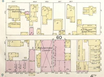
[[File:1891 Block 60 Sanborn map.jpg|right|thumb| | [[File:1891 Block 60 Sanborn map.jpg|right|thumb|400px|1891 Sanborn fire insurance map of Block 60]] | ||
[[File:Block 60 aerial view.png|right|thumb|400px|2020 aerial view of Block 60]] | |||
'''Block 60''' is a [[Birmingham]] [[Birmingham city center street grid|city block]] bordered by [[19th Street North|19th]] and [[20th Street North#4th Avenue North|20th Streets]] and by [[4th Avenue North|4th]] and [[5th Avenue North|5th Avenue]]s North, now the site of the [[Wells Fargo Tower]] and the [[Clark Building]]. | '''Block 60''' is a [[Birmingham]] [[Birmingham city center street grid|city block]] bordered by [[19th Street North|19th]] and [[20th Street North#4th Avenue North|20th Streets]] and by [[4th Avenue North|4th]] and [[5th Avenue North|5th Avenue]]s North, now the site of the [[Wells Fargo Tower]] and the [[Clark Building]]. | ||
Revision as of 18:31, 17 March 2020
Block 60 is a Birmingham city block bordered by 19th and 20th Streets and by 4th and 5th Avenues North, now the site of the Wells Fargo Tower and the Clark Building.
In 1982 developer Raymond Gotlieb of Metropolitan Properties beat out eleven other competitors for a redevelopment agreement with the City of Birmingham for Block 60, which was considered a part of the Downtown Master Plan recently prepared by Pedro Costa and Angelos Demetriou. Gotlieb proposed razing the block for a $120 million, 28-story crescent-shaped Westin hotel and office complex. His company failed to acquire enough property to proceed with the plan, and the City Council declined to pursue condemnation.
Birmingham's tallest building, SouthTrust Tower, was completed on the northeast corner of the block in August 1986.
References
- Frieden, Kitty (February 27, 1981) "Firm hopes to get key property pieces today for complex" The Birmingham News - via Birmingham Public Library Digital Collections
- Frieden, Kitty (March 21, 1982) "Big day near with Block 60; reputations are on the line" The Birmingham News - via Birmingham Public Library Digital Collections
- Frieden, Kitty (November 14, 1982) "Block 60 within reach, but Gotlieb still vague about swinging $10 million for it" The Birmingham News - via Birmingham Public Library Digital Collections

