Broadway Street: Difference between revisions
(→Notable locations: Another former tenant at 100.) |
No edit summary |
||
| (19 intermediate revisions by 4 users not shown) | |||
| Line 1: | Line 1: | ||
'''Broadway Street''' (labeled on street signs simply as '''Broadway''') is an approximately 1.4-mile residential street in [[Homewood]], connecting the [[Edgewood Business District]] on [[Oxmoor Road]] with [[Green Springs Highway]]. The winding road runs in a predominantly north-south direction. From a few houses north of Morris Boulevard to short of Green Springs, the road parallels [[Griffin Brook]], which runs behind the homes on the east side. | '''Broadway Street''' (labeled on street signs simply as '''Broadway''') is an approximately 1.4-mile residential street in [[Homewood]], connecting the [[Edgewood Business District]] on [[Oxmoor Road]] with [[Green Springs Highway]]. The winding road runs in a predominantly north-south direction. From a few houses north of Morris Boulevard to short of Green Springs, the road parallels [[Griffin Brook]], which runs behind the homes on the east side. | ||
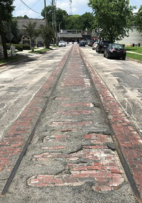
Although a two-lane street, Broadway is wider than most surrounding streets because it was originally part of the [[Birmingham | [[Image:Streetcar_tracks_along_Broadway_Street.jpg|right|thumb|200px|Streetcar tracks near Oxmoor Road intersection]] | ||
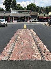
Although a two-lane street, Broadway is wider than most surrounding streets because it was originally part of the [[Birmingham & Edgewood Electric Railway]]'s streetcar route in the 1910s and 1920s. The streetcar stopped running prior to [[World War II]] and during the war a project was begun to salvage the tracks as scrap. Doing so proved financially prohibitive, so the tracks remained and were paved over in [[1968]] when the road was resurfaced. The tracks were uncovered during maintenance work in April 2018. Most of the road was paved over again, but a small section of the road with the original streetcar tracks was left uncovered for historical purposes. | |||
After Homewood incorporated in [[1926]], the [[Homewood City Council]] passed three improvement ordinances. Improvement Ordinance Number Two specified that a 40-foot roadway be paved with 14-inch curbs along Broadway from Oxmoor Road to what had previously been the [[Edgewood]] town limits, south of Forest Drive. In the late 1920s, the street was widened from [[Carr Avenue]] to [[Saulter Road]] to allow cars to pass safely. Prior to this, only the Edgewood Electric Railway line had extended past Carr. During the [[Great Depression]], federal relief-agency workers cut through 1,100 feet of rock to widen Broadway south of Saulter Road. | After Homewood incorporated in [[1926]], the [[Homewood City Council]] passed three improvement ordinances. Improvement Ordinance Number Two specified that a 40-foot roadway be paved with 14-inch curbs along Broadway from Oxmoor Road to what had previously been the [[Edgewood]] town limits, south of Forest Drive. In the late 1920s, the street was widened from [[Carr Avenue]] to [[Saulter Road]] to allow cars to pass safely. Prior to this, only the Edgewood Electric Railway line had extended past Carr. During the [[Great Depression]], federal relief-agency workers cut through 1,100 feet of rock to widen Broadway south of Saulter Road. | ||
The southern end of Broadway, just south of [[Saulter Road]], originally took a sharper turn to a route slightly north of the current route and then curved into [[Columbiana Road]] (that section of which later became part of Green Springs Highway). In the 1960s, this section of Broadway was straightened to provide a right-angle intersection with Green Springs, leaving a dead-end fork that provided access to [[Lakeshore Apartments]]. This dead-end segment remained until the construction of [[Broadway Park Condominiums]] around [[2005]], when the developer bought the 1.3-acre parcel between the apartments and the current Broadway from the city. | The southern end of Broadway, just south of [[Saulter Road]], originally took a sharper turn to a route slightly north of the current route and then curved into [[Columbiana Road]] (that section of which later became part of Green Springs Highway). In the 1960s, this section of Broadway was straightened to provide a right-angle intersection with Green Springs, leaving a dead-end fork that provided access to [[Lakeshore Apartments]]. This dead-end segment remained until the construction of [[Broadway Park Condominiums]] around [[2005]], when the developer bought the 1.3-acre parcel between the apartments and the current Broadway from the city. | ||
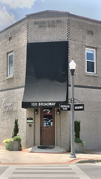
[[File:Markle-Reed Building.jpg|right|thumb|200px|The [[Markle-Reed Building]] at the intersection of Oxmoor Road and Broadway]] | |||
[[Image:Streetcar_tracks_along_Broadway_Street_after_repaving.jpg|right|thumb|200px|Streetcar tracks]] | |||
== Notable locations == | == Notable locations == | ||
| Line 11: | Line 14: | ||
* [[Oxmoor Road]] intersection ([[Edgewood Business District]]) | * [[Oxmoor Road]] intersection ([[Edgewood Business District]]) | ||
** | ** west side: | ||
*** 100: [[ | *** 100: [[Markle-Reed Building]], [[Blonde Salon Spa]]; originally [[Edgewood Drug Company]], later [[Greene Mar Drugs]], [[Markle Discount Drugs]], [[Markle Home Health Care Center]], [[Pet Safari]], and [[Escape Day Spa]] | ||
** | ** east side: | ||
*** [[Trilogy Leather]] | *** [[Trilogy Leather]] | ||
*** 111 | *** 111 | ||
**** Suite 3: [[Bella Bridesmaid]] | **** Suite 3: [[Bella Bridesmaid]] | ||
* College Avenue intersection (west only; access from [[Edgewood Elementary School]]) | * College Avenue intersection (west only; access from [[Edgewood Elementary School]]) | ||
* Roseland Drive intersection (east only) | * [[Roseland Drive]] intersection (east only) | ||
* Forest Drive intersection | * Forest Drive intersection | ||
** | ** east side: | ||
*** 719-721: [[Gian Marco's]] | *** 719-721: [[Gian Marco's]], former location of [[Stignani's Market & Deli]] | ||
**** 719: former location of [[Valentine Realty Co.]] (1969-1970) | |||
*** 731: [[Gianmarco Wine]] | *** 731: [[Gianmarco Wine]] | ||
* [[Carr Avenue]] intersection (west only) | * [[Carr Avenue]] intersection (west only) | ||
** | ** east side: | ||
*** 903 | *** 903 | ||
*** | **** Suite 105: [[Sorelle Cafe]] ([[Joy Smith (caterer)|Joy Smith]] August 2021–), former location of [[Lag's Eatery]] (1970s-2000s), [[Collage Catering]], [[JoJo's on Broadway]] (2012-2019), [[A Social Affair]] (-2021) | ||
**** Suite 103: former location of [[Barre & More]] fitness studio | |||
**** Suite 101: [[Monarch Cleaners]] | |||
* [[Saulter Road]] intersection (east only) | * [[Saulter Road]] intersection (east only) | ||
** | ** west side: | ||
*** [[Broadway Park Condominiums]] | *** [[Broadway Park Condominiums]] | ||
* [[Green Springs Highway]] intersection (continues across as [[Columbiana Road]]) | * [[Green Springs Highway]] intersection (continues across as [[Columbiana Road]]) | ||
| Line 35: | Line 41: | ||
{{Locate street|street=Broadway+St|city=Homewood}} | {{Locate street|street=Broadway+St|city=Homewood}} | ||
* {{Summe-2001}} | * {{Summe-2001}} | ||
* Atchison, Ray M. | * Atchison, Ray M. & Doris Teague Atchison (1999) ''[http://www.experiencedawson.com/index.php/welcome/history Light in the Valley]''. Dawson Memorial Baptist Church - accessed April 2, 2010 | ||
* Byington, Pat (July 9, 2018) "History preserved: unearthed 1920s Homewood trolley tracks incorporated in new road paving." ''Bham Now'' | |||
[[Category:Broadway Street|*]] | [[Category:Broadway Street|*]] | ||
Latest revision as of 13:01, 27 July 2021
Broadway Street (labeled on street signs simply as Broadway) is an approximately 1.4-mile residential street in Homewood, connecting the Edgewood Business District on Oxmoor Road with Green Springs Highway. The winding road runs in a predominantly north-south direction. From a few houses north of Morris Boulevard to short of Green Springs, the road parallels Griffin Brook, which runs behind the homes on the east side.
Although a two-lane street, Broadway is wider than most surrounding streets because it was originally part of the Birmingham & Edgewood Electric Railway's streetcar route in the 1910s and 1920s. The streetcar stopped running prior to World War II and during the war a project was begun to salvage the tracks as scrap. Doing so proved financially prohibitive, so the tracks remained and were paved over in 1968 when the road was resurfaced. The tracks were uncovered during maintenance work in April 2018. Most of the road was paved over again, but a small section of the road with the original streetcar tracks was left uncovered for historical purposes.
After Homewood incorporated in 1926, the Homewood City Council passed three improvement ordinances. Improvement Ordinance Number Two specified that a 40-foot roadway be paved with 14-inch curbs along Broadway from Oxmoor Road to what had previously been the Edgewood town limits, south of Forest Drive. In the late 1920s, the street was widened from Carr Avenue to Saulter Road to allow cars to pass safely. Prior to this, only the Edgewood Electric Railway line had extended past Carr. During the Great Depression, federal relief-agency workers cut through 1,100 feet of rock to widen Broadway south of Saulter Road.
The southern end of Broadway, just south of Saulter Road, originally took a sharper turn to a route slightly north of the current route and then curved into Columbiana Road (that section of which later became part of Green Springs Highway). In the 1960s, this section of Broadway was straightened to provide a right-angle intersection with Green Springs, leaving a dead-end fork that provided access to Lakeshore Apartments. This dead-end segment remained until the construction of Broadway Park Condominiums around 2005, when the developer bought the 1.3-acre parcel between the apartments and the current Broadway from the city.

Notable locations
- For an alphabetical list of locations, see the Broadway Street category.
- Oxmoor Road intersection (Edgewood Business District)
- west side:
- 100: Markle-Reed Building, Blonde Salon Spa; originally Edgewood Drug Company, later Greene Mar Drugs, Markle Discount Drugs, Markle Home Health Care Center, Pet Safari, and Escape Day Spa
- east side:
- Trilogy Leather
- 111
- Suite 3: Bella Bridesmaid
- west side:
- College Avenue intersection (west only; access from Edgewood Elementary School)
- Roseland Drive intersection (east only)
- Forest Drive intersection
- east side:
- 719-721: Gian Marco's, former location of Stignani's Market & Deli
- 719: former location of Valentine Realty Co. (1969-1970)
- 731: Gianmarco Wine
- 719-721: Gian Marco's, former location of Stignani's Market & Deli
- east side:
- Carr Avenue intersection (west only)
- east side:
- 903
- Suite 105: Sorelle Cafe (Joy Smith August 2021–), former location of Lag's Eatery (1970s-2000s), Collage Catering, JoJo's on Broadway (2012-2019), A Social Affair (-2021)
- Suite 103: former location of Barre & More fitness studio
- Suite 101: Monarch Cleaners
- 903
- east side:
- Saulter Road intersection (east only)
- west side:
- Green Springs Highway intersection (continues across as Columbiana Road)
References
- Summe, Sheryl Spradling. (2001). Homewood: The Life of a City. Homewood, AL: Friends of the Homewood Public Library.
- Atchison, Ray M. & Doris Teague Atchison (1999) Light in the Valley. Dawson Memorial Baptist Church - accessed April 2, 2010
- Byington, Pat (July 9, 2018) "History preserved: unearthed 1920s Homewood trolley tracks incorporated in new road paving." Bham Now

