Clarkson Bridge: Difference between revisions
(add photos & hmdb.org link) |
mNo edit summary |
||
| Line 1: | Line 1: | ||
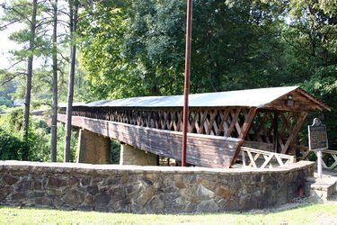
[[Image:Exterior_view_of_Clarkston_Covered_Bridge.jpg|right|thumb|375px| | [[Image:Exterior_view_of_Clarkston_Covered_Bridge.jpg|right|thumb|375px|Clarkson Covered Bridge in 2004]] | ||
The '''Clarkson Bridge''' (formerly '''Legg Bridge''') is a 270-foot long wooden covered bridge that spans [[Crooked Creek]] on [[Cullman County Road 1043|County Road 1043]] in [[Cullman County]]'s [[Clarkson Covered Bridge Park]], near [[Bethel]]. It is, after the [[Swann Bridge]], the second-longest in the state. | The '''Clarkson Bridge''' (formerly '''Legg Bridge''') is a 270-foot long wooden covered bridge that spans [[Crooked Creek]] on [[Cullman County Road 1043|County Road 1043]] in [[Cullman County]]'s [[Clarkson Covered Bridge Park]], near [[Bethel]]. It is, after the [[Swann Bridge]], the second-longest in the state. | ||
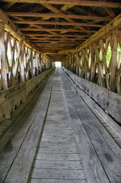
[[Image:Interior_view_of_Clarkston_Covered_Bridge.jpg|left|thumb|175px|Interior view of | [[Image:Interior_view_of_Clarkston_Covered_Bridge.jpg|left|thumb|175px|Interior view of Clarkson Covered Bridge in 2004]] | ||
The four-span bridge was constructed in [[1904]] for $1,500 on property owned by mail carrier [[James Legg]], who also supplied much of the material. It was built using the Town lattice truss design patented in 1820 by Ithiel Town of Connecticut, modified with the use of iron carriage bolts instead of oak pins. | The four-span bridge was constructed in [[1904]] for $1,500 on property owned by mail carrier [[James Legg]], who also supplied much of the material. It was built using the Town lattice truss design patented in 1820 by Ithiel Town of Connecticut, modified with the use of iron carriage bolts instead of oak pins. | ||
| Line 14: | Line 14: | ||
== External links == | == External links == | ||
{{Locate | lat=34.207522 | lon=-86.990931 |type=h|zoom=17}} | {{Locate | lat=34.207522 | lon=-86.990931 |type=h|zoom=17}} | ||
* [http:// | * [http://cullmancountyparks.com/clarkson.html Clarkson Covered Bridge Park] at cullmancountyparks.com | ||
* [http://www.dalejtravis.com/bridge/alabama/htm/0102201.htm Clarkson Bridge] at dalejtravis.com | * [http://www.dalejtravis.com/bridge/alabama/htm/0102201.htm Clarkson Bridge] at dalejtravis.com | ||
* [http://www.hmdb.org/marker.asp?marker=33833 Clarkston Covered Bridge] historical marker at hmdb.org | * [http://www.hmdb.org/marker.asp?marker=33833 Clarkston Covered Bridge] historical marker at hmdb.org | ||
Latest revision as of 23:07, 31 August 2016
The Clarkson Bridge (formerly Legg Bridge) is a 270-foot long wooden covered bridge that spans Crooked Creek on County Road 1043 in Cullman County's Clarkson Covered Bridge Park, near Bethel. It is, after the Swann Bridge, the second-longest in the state.
The four-span bridge was constructed in 1904 for $1,500 on property owned by mail carrier James Legg, who also supplied much of the material. It was built using the Town lattice truss design patented in 1820 by Ithiel Town of Connecticut, modified with the use of iron carriage bolts instead of oak pins.
Half of the bridge was carried away by a flood in 1921, but it was rebuilt by the County during the following year, re-using many of the timbers that had been recovered downstream. It remained in service until 1962 when a new concrete bridge was built.
The bridge was added to the National Register of Historic Places on June 25, 1974. The Cullman County Commission restored the bridge in 1975 as part of its American Revolution Bicentennial observances. A grist mill and log cabin were also restored nearby, forming the nucleus of Clarkson Covered Bridge Park, which hosts the annual Old-Fashioned Days festival. The park also includes the site of the "Battle of Hog Mountain", fought in darkness by General Nathan Bedford Forrest's cavalry against U. S. Colonel Abel Streight's raiders on their way toward Georgia in April 1863.
References
- Prince, A. G. (1981) Alabama's Covered Bridges: Past and Present. revised edition. Ensley: Best Printing Service
External links
- Clarkson Covered Bridge Park at cullmancountyparks.com
- Clarkson Bridge at dalejtravis.com
- Clarkston Covered Bridge historical marker at hmdb.org

