Dora: Difference between revisions
No edit summary |
|||
| (5 intermediate revisions by the same user not shown) | |||
| Line 1: | Line 1: | ||
{{Infobox City | name=Dora | |||
| type=City | |||
| logo=[[File:Dora seal.png]] | |||
| year=1897 | |||
| population=1,969 | |||
| mayor=Christopher Edwards | |||
| schools=Walker County Schools | |||
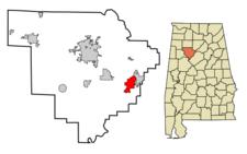
| map=[[Image:Dora locator map.png|225px]] | |||
| website=[http://www.walkercounty.us/dora/ walkercounty.us/dora] | |||
}} | |||
'''Dora''' is a city 1,969 on 7.5 square miles in [[Walker County]]. It was incorporated in [[1897]] as '''Horse Creek''' and renamed in [[1905]], in honor of [[Dora Freil]], wife of [[Hugh Freil]], the owner of the [[Victory Mines]] in the area. | |||
Dora is | |||
The settlement was called '''Sharon''' in the early 1880s. Its [[Dora Post Office|post office]] was established in [[1886]], the same year the [[Kansas City and Memphis and Birmingham Railroad]] came through the community. The name was changed to Horse Creek, after a nearby stream in [[1890]]. | |||
The [[Mayor of Dora]] is [[Christopher Edwards]]. Students in Dora attend [[T.S. Boyd Elementary/Junior High School]] and [[Dora High School]] within the [[Walker County Schools]] system. | |||
==Demographics== | ==Demographics== | ||
As of the census of [[ | As of the census of [[2010]], there were 2,025 people residing in the city's 820 occupied housing units, for an average household of 2.47 person. The population density was 270.0 people per square mile., with housing units at an average density of 109.3/sq mi. The racial makeup of the city was 85.6% White and 12.2% Black. 0.7% of the population (14 people) were Hispanic or Latino of any race. | ||
In [[2000]], there were 984 households out of which 32.9% had children under the age of 18 living with them, 50.3% were married couples living together, 18.8% had a female householder with no husband present, and 27.7% were non-families. 25.3% of all households were made up of individuals and 11.8% had someone living alone who was 65 years of age or older. The average household size was 2.45 and the average family size was 2.93. | |||
In the city the population was spread out with 26.2% under the age of 18, 8.8% from 18 to 24, 26.5% from 25 to 44, 25.1% from 45 to 64, and 13.5% who were 65 years of age or older. The median age was 36 years. For every 100 females there were 81.8 males. For every 100 females age 18 and over, there were 80.3 males. | In the city the population was spread out with 26.2% under the age of 18, 8.8% from 18 to 24, 26.5% from 25 to 44, 25.1% from 45 to 64, and 13.5% who were 65 years of age or older. The median age was 36 years. For every 100 females there were 81.8 males. For every 100 females age 18 and over, there were 80.3 males. | ||
The median income for a household in the city was $21,458, and the median income for a family was $29,000. Males had a median income of $28,942 versus $19,886 for females. The per capita income for the city was $14,560. About 23.1% of families and 27.9% of the population were below the poverty line, including 39.0% of those under age 18 and 23.5% of those age 65 or over. | The median income for a household in the city was $21,458, and the median income for a family was $29,000. Males had a median income of $28,942 versus $19,886 for females. The per capita income for the city was $14,560. About 23.1% of families and 27.9% of the population were below the poverty line, including 39.0% of those under age 18 and 23.5% of those age 65 or over. | ||
==References== | ==References== | ||
* | * {{Foscue-1989}} | ||
* "[http://en.wikipedia.org/w/index.php?title=Dora,_Alabama Dora, Alabama]" (August 8, 2008) Wikipedia - accessed August 20, 2008 | |||
{{Walker County}} | |||
[[Category:Dora|*]] | [[Category:Dora|*]] | ||
[[Category:1897 establishments]] | |||
Latest revision as of 12:20, 21 May 2015
| City of Dora | |

| |
| Incorporated | 1897 |
|---|---|
| Population | 1,969 |
| Mayor | Christopher Edwards |
| School district | Walker County Schools |
| Government |
Dora City Council |
| Web site | walkercounty.us/dora |

| |
| Locate with Google Maps | |
Dora is a city 1,969 on 7.5 square miles in Walker County. It was incorporated in 1897 as Horse Creek and renamed in 1905, in honor of Dora Freil, wife of Hugh Freil, the owner of the Victory Mines in the area.
The settlement was called Sharon in the early 1880s. Its post office was established in 1886, the same year the Kansas City and Memphis and Birmingham Railroad came through the community. The name was changed to Horse Creek, after a nearby stream in 1890.
The Mayor of Dora is Christopher Edwards. Students in Dora attend T.S. Boyd Elementary/Junior High School and Dora High School within the Walker County Schools system.
Demographics
As of the census of 2010, there were 2,025 people residing in the city's 820 occupied housing units, for an average household of 2.47 person. The population density was 270.0 people per square mile., with housing units at an average density of 109.3/sq mi. The racial makeup of the city was 85.6% White and 12.2% Black. 0.7% of the population (14 people) were Hispanic or Latino of any race.
In 2000, there were 984 households out of which 32.9% had children under the age of 18 living with them, 50.3% were married couples living together, 18.8% had a female householder with no husband present, and 27.7% were non-families. 25.3% of all households were made up of individuals and 11.8% had someone living alone who was 65 years of age or older. The average household size was 2.45 and the average family size was 2.93.
In the city the population was spread out with 26.2% under the age of 18, 8.8% from 18 to 24, 26.5% from 25 to 44, 25.1% from 45 to 64, and 13.5% who were 65 years of age or older. The median age was 36 years. For every 100 females there were 81.8 males. For every 100 females age 18 and over, there were 80.3 males.
The median income for a household in the city was $21,458, and the median income for a family was $29,000. Males had a median income of $28,942 versus $19,886 for females. The per capita income for the city was $14,560. About 23.1% of families and 27.9% of the population were below the poverty line, including 39.0% of those under age 18 and 23.5% of those age 65 or over.
References
- Foscue, Virginia O. (1989) Place Names in Alabama. Tuscaloosa: University of Alabama Press. ISBN 081730410X
- "Dora, Alabama" (August 8, 2008) Wikipedia - accessed August 20, 2008
| Walker County | |
|---|---|
| Topics | |
| Cities |
Carbon Hill | Cordova | Curry | Dora | Eldridge | Jasper (seat) | Kansas | Nauvoo | Oakman | Parrish | Sipsey | Sumiton |