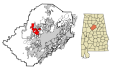
Adamsville
| City of Adamsville | |

| |
| Incorporated | 1901, 1953 |
|---|---|
| Population | 4,435 |
| Mayor | Pam Palmer |
| School district | Jefferson County Schools |
| Government |
Adamsville City Council |
| Web site | cityofadamsville.org |

| |
| Locate with Google Maps | |
Adamsville (incorporated in 1901 and reincorporated in 1953) is a city of 4,435 on 25.14 square miles in northwest Jefferson County along U.S. Highway 78. Its post office (35005) was established in 1890.
The mayor is Pam Palmer. The Adamsville City Council meets at Adamsville City Hall.
Adamsville residents are served by Adamsville Elementary School, Crumly Chapel Elementary School, Bottenfield Middle School and Minor High School, all in the Jefferson County School System.
The city maintains the Adamsville Fire and Rescue Service, the Adamsville Police Department and a department of Public Works which oversees the maintenance of streets, parks, sanitation and city equipment. Blackwell Park is the city's largest municpal park, followed by Leland Adams Park and Spring Street Park. The Adamsville Public Library is part of the Jefferson County Library System. Adamsville's municipal court is located at 4912 Bankhead Highway and is presided over by Judge Milton Barker.
History
Adamsville is named in honor of William Minus Adams, a local landholder who deeded a 100-foot right of way to the Kansas City, Memphis and Birmingham Railroad in 1886 and allowed his home to be used as a provisional depot. The agreement between the railroad and Adams specified that the town's name could not be changed, a stipulation that survived some later challenges.
About 1890 coal seams were discovered in the vicinity of Adamsville, helping the depot become a boom town. Adams subdivided large sections of his remaining property into 30x200 lots for sale. The hillsides became dotted with mine openings and coke ovens. The area around the depot took on the flavor of a rough frontier town with wooden sidewalks connecting its saloons.
The town was incorporated in 1901, but its politics, influenced by "whiskey interests" were quickly deemed intolerable. Mayor Robert Glasgow and a group of citizens convinced the legislature to revoke its charter.
Beginning in 1950 the Adamsville Lions Club led efforts to reorganize a city government, and the city was re-incorporated on October 13, 1953. Robert Glasgow Jr, son of the early mayor, was elected to the same office.
Demographics
| Historical population | ||
|---|---|---|
| Census | Pop. | %± |
| 1960 | 2,095 | - |
| 1970 | 2,412 | 15.1% |
| 1980 | 2,498 | 3.6% |
| 1990 | 4,161 | 66.6% |
| 2000 | 4,965 | 19.3% |
| 2010 | 4,522 | -8.9% |
As of the census of 2010, there were 4,522 people residing in the city's 1,990 housing units for an average household of 2.27 persons. The population density was 179.86/mi², with housing units at an average density of 79.15/mi². The racial makeup of the city was 52.3% White and 44.9% African American. 2.26% of the population was Hispanic or Latino of any race.
In 2000, there were 1,930 households, of which 32.1% had children under the age of 18 living with them, 59.1% were married couples living together, 13.5% had a female householder with no husband present, and 24.1% were non-families. 21.7% of all households were made up of individuals and 9.1% had someone living alone who was 65 years of age or older. The average household size was 2.56 and the average family size was 2.97.
In the city the population was spread out with 23.1% under the age of 18, 8.0% from 18 to 24, 27.6% from 25 to 44, 25.1% from 45 to 64, and 16.1% who were 65 years of age or older. The median age was 39 years. For every 100 females there were 90.9 males. For every 100 females age 18 and over, there were 88.2 males.
The median income for a household in the city was $39,563, and the median income for a family was $46,270. Males had a median income of $36,188 versus $22,292 for females. The per capita income for the city was $18,496. About 5.1% of families and 6.4% of the population were below the poverty line, including 10.3% of those under age 18 and 9.1% of those age 65 or over.
The Jefferson County Board of Equalization evaluated 1,743 homes in Adamsville and determined that their average market value for 2007 was $96,415, a 4.6% increase since 2006.
References
- "Adamsville, Alabama" (June 22, 2010) Wikipedia - accessed June 22, 2010
- Foscue, Virginia O. (1989) Place Names in Alabama. Tuscaloosa: University of Alabama Press. ISBN 081730410X
- Wilson, Alton (1992) "History of Adamsville". Founders Day Festival program, rpt. in The Heritage of Jefferson County, Alabama (2002) Clanton: Heritage Publishing Consultants. ISBN 1891647547
External links
- Adamsville official website
| Jefferson County | |
|---|---|
| Topics |
Communities | County Commission | Courts | Schools | Sheriff |
| Cities |
Adamsville | Bessemer (seat) | Birmingham (seat) | Brighton | Brookside | Cardiff | Center Point | Clay | Fairfield | Fultondale | Gardendale | Graysville | Homewood | Hoover | Hueytown | Irondale | Kimberly | Leeds | Lipscomb | Maytown | Midfield | Morris | Mountain Brook | Mulga | North Johns | Pinson | Pleasant Grove | Sylvan Springs | Tarrant | Trafford | Trussville | Vestavia Hills | Warrior | West Jefferson |
