Fultondale
| City of Fultondale | |

| |
| Incorporated | 1947 |
|---|---|
| Population | 9,284 |
| Mayor | Larry Holcomb |
| School district | Jefferson County Schools |
| Government |
Fultondale City Council |
| Web site | cityoffultondale.com |

| |
| Locate with Google Maps | |
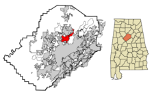
Fultondale (incorporated in 1947) is a city of 9,284 encompassing 12.2 square miles directly north of Birmingham. It adjoins Tarrant to the east and Gardendale to the north and is traversed by I-65 and Highway 31. Its post office (Zip Code 35068) was established in 1950.
Downtown Fultondale is located on Walker Chapel Road near the Seaboard System Railroad and south of its crossing with the CSX Transportation Railroad. A. T. Holt Park is located west of downtown near I-65.
The southern part of Fultondale borders Five Mile Creek, which is also a corridor for the Norfolk Southern Railroad. The route of I-22 intersects a small part of southwest Fultondale.
Fultondale's mayor is Larry Holcomb. As of 2012 the five-member Fultondale City Council consists of Greg Morris (mayor pro-tem), Joe Bolten, Darrell Hubbert, Tommy Loden, and Josh Bryant. William Howell was appointed to take the place of long-time councilor W. J. Alexander, who died after winning re-election in 2004. Howell left office in 2012 by virtue of moving his residence to Gardendale. Bryant, a firefighter, was appointed to fill his remaining term. Greg Morris, who served on the council for seven terms (1984-2016) and Darrell Hubbert, who served 18 years (1998-2016) were replaced at the end of 2016 by new council members Jimmie Lay and Darrell Bates. Council members elected in 2020 include Josh Bryant, Kristi Jennings, Jimmie Lay, Timothy McWilliams, and Billy Hughes.
The city operates its own garbage service, library, fire department, police department.
Fultondale High School and Fultondale Elementary School are part of the Jefferson County School System.
History
The settlements that evolved into Fultondale started as coal mining communities. The Mary Lee mine was located near Fultondale and had extensive beehive coking ovens. The Louisville and Nashville Railroad built a loop of track through the Fultondale area to facilitate coal hauling operations. The name is a combination of the names of two of those communities, Fulton Springs and Glendale.
Residents of Fultondale were the most productive contributors to the 2006 "Great Backyard Birdcount" sponsored by the Cornell Lab of Ornithology and Audubon. [1]
Demographics
As of the census of 2010, there were 8,380 people residing in Fultondale's 3,758 housing units, for an average household of 2.23 persons. The population density was 687.1/mi², with housing units at an average density of 308.1/mi². The racial makeup of the city was 75.14% White and 16.6% Black. 10.9% of the population were Hispanic or Latino of any race.
In 2000, there were 2,722 households, of which 28.0% had children under the age of 18 living with them, 55.3% were married couples living together, 11.9% had a female householder with no husband present, and 29.2% were non-families. 25.6% of all households were made up of individuals and 10.1% had someone living alone who was 65 years of age or older. The average household size was 2.42 and the average family size was 2.90.
In the city the population was spread out with 22.0% under the age of 18, 9.4% from 18 to 24, 28.7% from 25 to 44, 24.9% from 45 to 64, and 14.9% who were 65 years of age or older. The median age was 38 years. For every 100 females there were 92.1 males. For every 100 females age 18 and over, there were 89.5 males.
The median income for a household in the city was $38,006, and the median income for a family was $44,073. Males had a median income of $33,447 versus $25,700 for females. The per capita income for the city was $18,656. About 7.9% of families and 11.0% of the population were below the poverty line, including 16.6% of those under age 18 and 11.9% of those age 65 or over.
The Jefferson County Board of Equalization evaluated 2,306 homes in Fultondale and determined that the average market value for 2007 was $117,938, an 8.5% increase since 2006.
See also
References
- Foscue, Virginia O. (1989) Place Names in Alabama. Tuscaloosa: University of Alabama Press. ISBN 081730410X
- "Fultondale, Alabama (June 23, 2010) Wikipedia - accessed June 23, 2010
- Davis, Rachel (October 25, 2016) "Fultondale Council says goodbye to 2 longtime council members". North Jefferson News
External links
- City of Fultondale website
| Jefferson County | |
|---|---|
| Topics |
Communities | County Commission | Courts | Schools | Sheriff |
| Cities |
Adamsville | Bessemer (seat) | Birmingham (seat) | Brighton | Brookside | Cardiff | Center Point | Clay | Fairfield | Fultondale | Gardendale | Graysville | Homewood | Hoover | Hueytown | Irondale | Kimberly | Leeds | Lipscomb | Maytown | Midfield | Morris | Mountain Brook | Mulga | North Johns | Pinson | Pleasant Grove | Sylvan Springs | Tarrant | Trafford | Trussville | Vestavia Hills | Warrior | West Jefferson |