Birmingham Water Works Tunnel: Difference between revisions
| Line 17: | Line 17: | ||
* Satterfield, Carolyn Green (1976) ''Historic Sites of Jefferson County, Alabama''. Birmingham: Jefferson County Historical Commission. | * Satterfield, Carolyn Green (1976) ''Historic Sites of Jefferson County, Alabama''. Birmingham: Jefferson County Historical Commission. | ||
* Morris, Philip & Marjorie Longenecker White (1997) ''Birmingham Bound, An Atlas of the South's Premier Industrial Region''. Birmingham, Alabama: Birmingham Historical Society. ISBN 0943994225 | * Morris, Philip & Marjorie Longenecker White (1997) ''Birmingham Bound, An Atlas of the South's Premier Industrial Region''. Birmingham, Alabama: Birmingham Historical Society. ISBN 0943994225 | ||
[[Category:Red Mountain]] | [[Category:Red Mountain]] | ||
Revision as of 15:07, 30 August 2007
The Birmingham Water Works Tunnel is a 2,126-foot-long1. by 12-foot diameter inclined tunnel bored through Red Mountain near Lone Pine Gap in 1888. The tunnel served to bring water from the Cahaba River into downtown Birmingham.
The tunnel was a project of the Birmingham Water Works Company, a subsidiary of the Elyton Land Company and predecessor to the public board that serves today as the Birmingham Water Works. It was designed by chief engineer W. A. Merkel and built by the Dunn Brothers Construction Company, a railroad construction company that later relocated from Virginia to Birmingham.
The tunnel contains two massive water mains, one 42 inches and the other 36 inches in diameter. The water is drawn from the Cahaba at the Cahaba Pumping Station on Pump House Road, which forces it over the ridge of Shades Mountain to the Shades Mountain Water Treatment Plant on U. S. Highway 280. From there it is drawn into Homewood by the Rosedale Pump House (constructed in 1910) and then falls by gravity through the long tunnel into Birmingham.
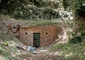
As it approaches Lone Pine Gap, the tunnel lies roughly parallel to 18th Street. It continues beneath Vulcan Park and 16th Street South to a stone headwall in a neighborhood park just below the street. A metal gate provides access to large cast-iron gate valves at that location. The interior of the tunnel is supported periodically by brick arches.
The Birmingham Water Works Tunnel figures prominently in the novel Threshold by Caitlín R. Kiernan.
Notes
- Various references give the tunnel's length at 2,126 feet, 2,167 feet, and 2,200 feet.
References
- Satterfield, Carolyn Green (1976) Historic Sites of Jefferson County, Alabama. Birmingham: Jefferson County Historical Commission.
- Morris, Philip & Marjorie Longenecker White (1997) Birmingham Bound, An Atlas of the South's Premier Industrial Region. Birmingham, Alabama: Birmingham Historical Society. ISBN 0943994225
