Lone Pine Gap: Difference between revisions
No edit summary |
No edit summary |
||
| (6 intermediate revisions by 2 users not shown) | |||
| Line 1: | Line 1: | ||
'''Lone Pine Gap''', also called '''Parton's Gap''', is a gap through [[Red Mountain]] between [[Birmingham]]'s [[South Highlands]] and [[Homewood]]. It was deepened by a cut for the [[Birmingham Mineral Railroad]], exposing a section of the mountain's ore-bearing geology that was reported widely at the turn of the 19th century. The [[iron ore]]-bearing strata exposed included the 17-foot-thick "[[Big seam]]" and the 6-foot-thick "[[Irondale seam]]", both part of the [[Clinton formation]]. | |||
''' | |||
The [[Lone Pine Mines]] were sunk into the northern slopes of Red Mountain near the gap and just below the ridge around [[1904]] and were operated by the [[Tennessee Coal, Iron & Railroad Company]]. | The [[Lone Pine Mines]] were sunk into the northern slopes of Red Mountain near the gap and just below the ridge around [[1904]] and were operated by the [[Tennessee Coal, Iron & Railroad Company]]. | ||
| Line 12: | Line 9: | ||
The roadway was gradually improved for adventurous motor-car drivers as [[18th Street South]], and later as part of the [[Montgomery Highway]], until it was by-passed by the opening of the [[Red Mountain cut]] to the east. | The roadway was gradually improved for adventurous motor-car drivers as [[18th Street South]], and later as part of the [[Montgomery Highway]], until it was by-passed by the opening of the [[Red Mountain cut]] to the east. | ||
Five acres of TCI's former mining property was donated to [[Birmingham]] as the site for [[Vulcan Park]] in the mid-1930s. | Five acres of TCI's former mining property was donated to [[Birmingham]] as the site for [[Vulcan Park]] in the mid-1930s. On [[November 8]], [[1949]] [[Iron Ore Seam signs|metal signs]] donated by engineer [[Erskine Ramsay]] were installed on the roadway cut to highlight the exposed iron ore seam. | ||
{{stub}} | {{stub}} | ||
{{Start box}} | |||
{{Location E-W box|title=[[Red Mountain]] passes|west=[[Walker's Gap]]|east=[[Red Mountain cut]]}} | |||
{{End box}} | |||
==Gallery== | |||
<gallery> | |||
Image:Lone Pine Gap 1910.jpg|Lone Pine Gap c. 1910 | |||
File:1910 Good Road Tour at Lone Pine Gap.jpg|Motorists pose at Lone Pine Gap in 1910 | |||
File:Edgewood streetcar track at Lone Pine Gap.jpg|Lone Pine Gap in 1915 | |||
File:1951 monorail crossing Lone Pine Gap.jpg|1951 rendering of an imagined monorail at Lone Pine Gap | |||
</gallery> | |||
==External links== | ==External links== | ||
{{Locate | lat= 33.4920755 | lon=-86.7949572 | zoom=15 | type=p }} | {{Locate | lat= 33.4920755 | lon=-86.7949572 | zoom=15 | type=p }} | ||
Latest revision as of 10:16, 10 May 2021
Lone Pine Gap, also called Parton's Gap, is a gap through Red Mountain between Birmingham's South Highlands and Homewood. It was deepened by a cut for the Birmingham Mineral Railroad, exposing a section of the mountain's ore-bearing geology that was reported widely at the turn of the 19th century. The iron ore-bearing strata exposed included the 17-foot-thick "Big seam" and the 6-foot-thick "Irondale seam", both part of the Clinton formation.
The Lone Pine Mines were sunk into the northern slopes of Red Mountain near the gap and just below the ridge around 1904 and were operated by the Tennessee Coal, Iron & Railroad Company.
Except for the Mineral Railroad, the gap carried little more than a "pig trail" Over the Mountain to Shades Valley, crossing the railroad bed on a "wagon bridge". The pass was made briefly more accessible by the Red Mountain Railroad, backed by the Clifton Land Company, which operated between 1889 and 1893.
In 1909 the Edgewood Electric Railway, a service incorporated by Troupe Brazleton and Stephen Smith, developers of the Edgewood Lake resort and Edgewood residential subdivision in present-day Homewood struck a deal to lower the road bed about 72 feet, passing under the Mineral Railroad. Jefferson County contributed to the project in return for the establishment of a 16-foot-wide right of way for automobile traffic.
The roadway was gradually improved for adventurous motor-car drivers as 18th Street South, and later as part of the Montgomery Highway, until it was by-passed by the opening of the Red Mountain cut to the east.
Five acres of TCI's former mining property was donated to Birmingham as the site for Vulcan Park in the mid-1930s. On November 8, 1949 metal signs donated by engineer Erskine Ramsay were installed on the roadway cut to highlight the exposed iron ore seam.
| To the west: Walker's Gap |
Red Mountain passes Lone Pine Gap |
To the east: Red Mountain cut |
Gallery
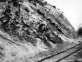
Lone Pine Gap c. 1910
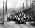
Motorists pose at Lone Pine Gap in 1910
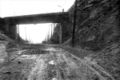
Lone Pine Gap in 1915
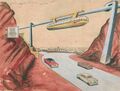
1951 rendering of an imagined monorail at Lone Pine Gap


