Mad Town: Difference between revisions
No edit summary |
No edit summary |
||
| Line 4: | Line 4: | ||
Some sources indicate that it was located at the confluence of the [[Little Cahaba River|Little Cahaba]], just above the present crossing of [[U.S. Highway 280]]. Others place it further downstream, at the site where the [[Altadena Valley Country Club]] was later developed. Sources also disagree on whether the settlement was on the east or west bank of the river. | Some sources indicate that it was located at the confluence of the [[Little Cahaba River|Little Cahaba]], just above the present crossing of [[U.S. Highway 280]]. Others place it further downstream, at the site where the [[Altadena Valley Country Club]] was later developed. Sources also disagree on whether the settlement was on the east or west bank of the river. | ||
In any case, the town was founded as a northern outpost of the Upper Creek tribes, used by traders and serving as an important landmark on the [[Bear Meat Cabin Road]] or "Great Tennessee Trail" from Ditto's Landing on the Tennessee to [[Old Town]] on the [[Warrior River]] that later became the [[Huntsville Pike]]. | In any case, the town was founded as a northern outpost of the Upper Creek tribes, used by traders and serving as an important landmark on the [[Bear Meat Cabin Road]] or "Great Tennessee Trail" from Ditto's Landing on the Tennessee to [[Old Town]] on the [[Warrior River]] that later became the [[Huntsville Pike]]. According to researchers for the WPA's Writers' Program, the town marked the junction of the East-West Trail from the Carolinas to Mississippi and the Great Trade Path connecting the Great Lakes to the Gulf of Mexico. | ||
During the [[Creek Indian War]] the town was cleared out and burned on [[May 1]], [[1814]] by [[John Coffee]]'s forces on Andrew Jackson's orders. | During the [[Creek Indian War]] the town was cleared out and burned on [[May 1]], [[1814]] by [[John Coffee]]'s forces on Andrew Jackson's orders. [[Joseph Roy]], an early settler in Shelby County, is said to have erected his cabin on the bank opposite Mud Town in [[1815]] or [[1816]]. [[Virginia Duffy]] remembered Mudtown as still being used by a dwindling band of Indian "vagabond traders" at the end of the decade. It appeared on an [[1825]] map as "Ruins of Mad T." | ||
==See also== | ==See also== | ||
| Line 17: | Line 17: | ||
* {{Cruikshank-1920}} | * {{Cruikshank-1920}} | ||
* {{Owen-1921}} | * {{Owen-1921}} | ||
* {{WPA-1941}} | |||
* United States Forest Service (April 1977) ''[http://archive.org/details/CAT78694361 Alabama River Basin Cooperative Study]'' | |||
* United States Forest Service (1979) ''[http://books.google.com/books?id=uoU2AQAAMAAJ Cahaba River, Alabama: Wild and Scenic River Study Report]'' | * United States Forest Service (1979) ''[http://books.google.com/books?id=uoU2AQAAMAAJ Cahaba River, Alabama: Wild and Scenic River Study Report]'' | ||
* {{Barefield-1989}} | * {{Barefield-1989}} | ||
Revision as of 16:11, 9 May 2016
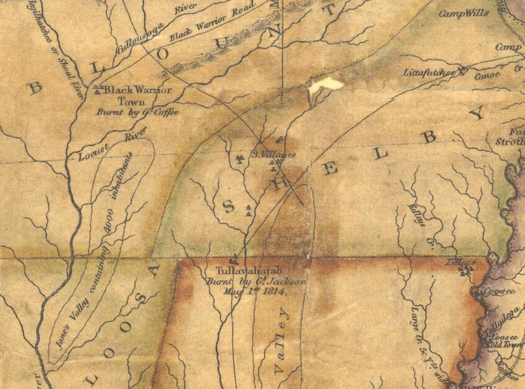
Mud Town (also called Mudd Town, Mad Town, or Old Mudtown or, in transliteration of its Muscogean name, Talooehajah, Tulawahajah,Tullavahajah, or Tulauhabsho) was a name used for a settlement used by Indian traders on the banks of the Cahaba River in present day Shelby County.
Some sources indicate that it was located at the confluence of the Little Cahaba, just above the present crossing of U.S. Highway 280. Others place it further downstream, at the site where the Altadena Valley Country Club was later developed. Sources also disagree on whether the settlement was on the east or west bank of the river.
In any case, the town was founded as a northern outpost of the Upper Creek tribes, used by traders and serving as an important landmark on the Bear Meat Cabin Road or "Great Tennessee Trail" from Ditto's Landing on the Tennessee to Old Town on the Warrior River that later became the Huntsville Pike. According to researchers for the WPA's Writers' Program, the town marked the junction of the East-West Trail from the Carolinas to Mississippi and the Great Trade Path connecting the Great Lakes to the Gulf of Mexico.
During the Creek Indian War the town was cleared out and burned on May 1, 1814 by John Coffee's forces on Andrew Jackson's orders. Joseph Roy, an early settler in Shelby County, is said to have erected his cabin on the bank opposite Mud Town in 1815 or 1816. Virginia Duffy remembered Mudtown as still being used by a dwindling band of Indian "vagabond traders" at the end of the decade. It appeared on an 1825 map as "Ruins of Mad T."
See also
- "Mudd's Town", reportedly an alternative suggestion for the name of Birmingham, presumably to honor Judge William Mudd
- Mudtown Eat & Drink, a restaurant in Cahaba Heights
References
- Dubose, John Witherspoon (1887) Jefferson County and Birmingham, Alabama: Historical and Biographical Birmingham: Teeple & Smith, Publishers; Caldwell Printing Works.
- Armes, Ethel (1910) The Story of Coal and Iron in Alabama. Birmingham: Birmingham Chamber of Commerce
- Cruikshank, George H. (1920) History of Birmingham and Its Environs: A Narrative Account of Their Historical Progress, Their People, and Their Principal Interests 2 volumes. Chicago, Illinois: Lewis Publishing Company. - via Birmingham Public Library Digital Collections
- Owen, Thomas McAdory and Marie Bankhead Owen (1921) History of Alabama and Dictionary of Alabama Biography. 4 volumes. Chicago, Illinois: S. J. Clarke Publishing Co.
- Alabama Writers Project (1941) Alabama: a Guide to the Deep South. Alabama State Planning Commission/Works Progress Administration
- United States Forest Service (April 1977) Alabama River Basin Cooperative Study
- United States Forest Service (1979) Cahaba River, Alabama: Wild and Scenic River Study Report
- Barefield, Marilyn Davis (1989) A History of Mountain Brook, Alabama and Incidentally of Shades Valley Birmingham: Southern University Press ISBN 0876519907
