Birmingham-Hoover-Cullman Combined Statistical Area: Difference between revisions
Jump to navigation
Jump to search
(New page: thumb|right|Birmingham-Hoover-Cullman CSA The '''Birmingham-Hoover-Cullman Combined Statistical Area''' is a United States Census-designate...) |
(Now outdated.) |
||
| Line 1: | Line 1: | ||
[[Image:Birmingham-Hoover-Cullman CSA map.png|thumb|right|Birmingham-Hoover-Cullman CSA]] | [[Image:Birmingham-Hoover-Cullman CSA map.png|thumb|right|Birmingham-Hoover-Cullman CSA]] | ||
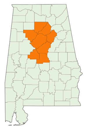
The '''Birmingham-Hoover-Cullman Combined Statistical Area''' | The '''Birmingham-Hoover-Cullman Combined Statistical Area''' was a United States Census-designated area. It comprised [[Jefferson County|Jefferson]], [[Shelby County|Shelby]], [[St Clair County|St Clair]], [[Walker County|Walker]], [[Blount County|Blount]], [[Chilton County|Chilton]] and [[Bibb County|Bibb]] counties from the [[Birmingham-Hoover Metropolitan Statistical Area]] with the [[Cullman Micropolitan Statistical Area]] (which corresponds with the area of [[Cullman County]]). | ||
The July 2008 population estimate for the Birmingham-Hoover-Cullman CSA, released on March 20, 2009, | The July 2008 population estimate for the Birmingham-Hoover-Cullman CSA, released on March 20, 2009, was 1,198,932, or approximately one fourth of Alabama's overall population. | ||
In 2013, the Office of Management and Budget redefined the various statistical areas and replaced the Birmingham-Hoover-Cullman Combined Statistical Area with the [[Birmingham-Hoover-Talladega Combined Statistical Area]]. | |||
== See also == | == See also == | ||
| Line 10: | Line 12: | ||
==Reference== | ==Reference== | ||
* [http://en.wikipedia.org/w/index.php?title=Birmingham%E2%80%93Hoover%E2%80%93Cullman_Combined_Statistical_Area&oldid=344362988 Birmingham–Hoover–Cullman Combined Statistical Area] (February 16, 2010). Wikipedia, The Free Encyclopedia - accessed March 25, 2010 | * [http://en.wikipedia.org/w/index.php?title=Birmingham%E2%80%93Hoover%E2%80%93Cullman_Combined_Statistical_Area&oldid=344362988 Birmingham–Hoover–Cullman Combined Statistical Area] (February 16, 2010). Wikipedia, The Free Encyclopedia - accessed March 25, 2010 | ||
* [https://obamawhitehouse.archives.gov/sites/default/files/omb/bulletins/2013/b13-01.pdf Revised Delineations of Metropolitan Statistical Areas, Micropolitan Statistical Areas, and Combined Statistical Areas, and Guidance on Uses of the Delineations of These Areas] (February 28, 2013). OMB. | |||
[[Category:Census areas]] | [[Category:Census areas]] | ||
Latest revision as of 21:14, 15 June 2021
The Birmingham-Hoover-Cullman Combined Statistical Area was a United States Census-designated area. It comprised Jefferson, Shelby, St Clair, Walker, Blount, Chilton and Bibb counties from the Birmingham-Hoover Metropolitan Statistical Area with the Cullman Micropolitan Statistical Area (which corresponds with the area of Cullman County).
The July 2008 population estimate for the Birmingham-Hoover-Cullman CSA, released on March 20, 2009, was 1,198,932, or approximately one fourth of Alabama's overall population.
In 2013, the Office of Management and Budget redefined the various statistical areas and replaced the Birmingham-Hoover-Cullman Combined Statistical Area with the Birmingham-Hoover-Talladega Combined Statistical Area.
See also
Reference
- Birmingham–Hoover–Cullman Combined Statistical Area (February 16, 2010). Wikipedia, The Free Encyclopedia - accessed March 25, 2010
- Revised Delineations of Metropolitan Statistical Areas, Micropolitan Statistical Areas, and Combined Statistical Areas, and Guidance on Uses of the Delineations of These Areas (February 28, 2013). OMB.
