Harpersville: Difference between revisions
(Infobox) |
No edit summary |
||
| (6 intermediate revisions by 2 users not shown) | |||
| Line 1: | Line 1: | ||
{{Infobox City|name=Harpersville | {{Infobox City|name=Harpersville | ||
|type=Town | |type=Town | ||
|year= | |year=1944 | ||
|population=1, | |logo=[[Image:Harpersville sign.jpg|195px]] | ||
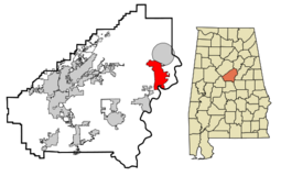
|map=[[Image:Harpersville locator map.png|255px]] | |||
|population=1,682 | |||
|mayor=Theoangelo Perkins | |mayor=Theoangelo Perkins | ||
|schools=Shelby County Schools | |schools=Shelby County Schools | ||
| Line 8: | Line 10: | ||
|website=[http://www.townofharpersville.com/ townofharpersville.com] | |website=[http://www.townofharpersville.com/ townofharpersville.com] | ||
}} | }} | ||
'''Harpersville''' is a town in [[Shelby County]]. | '''Harpersville''' is a town of 1,682 on on 15.9 square miles at the junction of [[U. S. Highway 280]] and [[U.S. Highway 231]] near the [[Coosa River]] in eastern [[Shelby County]]. The current mayor, [[Theoangelo Perkins]], is the first African-American mayor elected in Shelby County. | ||
Originally called '''Big Springs''', the town, first settled around 1815 [[William Harper|William Webb Harper]], who sold property in [[1816]] to [[John Kidd|John White Kidd]]. Harper's four brothers joined him, and by [[1820]] the community was already being referred to as Harpersville. | |||
The Harpersville post office was established at [[Tom Martin]]'s store in [[1843]]. [[Elmhill Academy]] was constructed as a boarding school in the community, and established the town as an education center. Electricity was brought to Harpersville by the [[Alabama Power Company]] in [[1928]]. | |||
The town was incorporated on [[March 17]], [[1944]] with [[J. W. Donahoo]] as its [[Mayor of Harpersville|mayor]]. The former [[Harpersville School]] was purchased for use as the [[Harpersville Town Hall]]. | |||
A notorious [[Harpersville speed trap]] was investigated and stopped in [[1952]] by the [[Alabama Motorists Association]]. The central area of Harpersville was hit by a [[1964 Harpersville tornado|deadly tornado]] on [[January 24]], [[1964]], killing 10 people. | |||
Currently the town contains [[Morgan Creek Winery]], [[Baker's Christmas Tree Farm]], a [[Harpersville Garden of Memories|historic graveyard]], Sunbelt sod farm, a drive-in movie theater, numerous cotton fields, a public park, two private schools, and numerous subdivisions. | |||
In [[2012]] a Judge [[Hub Harrington]] ruled in a lawsuit that the [[Harpersville Municipal Court]], in league with [[Judicial Corrections Services]], a private company, was operating as a "judicially sanctioned extortion racket" and ordered changes that led the [[Harpersville City Council]] to abolish the department that summer. The resulting loss of around $275,000 in annual revenues caused a budget crisis which was only partially relieved when the city hiked its [[sales tax]] rate to 9% in [[2013]]. | |||
==Demographics== | ==Demographics== | ||
As of the census of 2000, there were 1,620 people, 610 households, and 458 families residing in the town. The population density was 102.0 people per square mile | As of the census of 2000, there were 1,620 people, 610 households, and 458 families residing in the town. The population density was 102.0 people per square mile. There were 685 housing units at an average density of 43.1/sq mi. The racial makeup of the town was 70% White and 29% Black. | ||
There were 610 households out of which 33.9% had children under the age of 18 living with them, 57.4% were married couples living together, 14.8% had a female householder with no husband present, and 24.8% were non-families. 21.8% of all households were made up of individuals and 9.2% had someone living alone who was 65 years of age or older. The average household size was 2.66 and the average family size was 3.10. | There were 610 households out of which 33.9% had children under the age of 18 living with them, 57.4% were married couples living together, 14.8% had a female householder with no husband present, and 24.8% were non-families. 21.8% of all households were made up of individuals and 9.2% had someone living alone who was 65 years of age or older. The average household size was 2.66 and the average family size was 3.10. | ||
| Line 24: | Line 32: | ||
The median income for a household in the town was $31,655, and the median income for a family was $34,632. Males had a median income of $28,839 versus $22,069 for females. The per capita income for the town was $12,783. About 17.4% of families and 19.3% of the population were below the poverty line, including 23.6% of those under age 18 and 24.1% of those age 65 or over. | The median income for a household in the town was $31,655, and the median income for a family was $34,632. Males had a median income of $28,839 versus $22,069 for females. The per capita income for the town was $12,783. About 17.4% of families and 19.3% of the population were below the poverty line, including 23.6% of those under age 18 and 24.1% of those age 65 or over. | ||
== Notable residents == | |||
* [[Warren Kidd]] (1970–), basketball player | |||
* [[George McGinnis]] (1950–), basketball player | |||
* [[William Joseph Simmons]] (1880-1945), founder of the second [[Ku Klux Klan]] | |||
* [[Henry B. Walthall]] (1878–1936), actor | |||
== References == | == References == | ||
* | * Nixon, Ophelia (February 28, 1929) "History of Harpersville". ''Shelby County Reporter'' | ||
*{{Foscue-1989}} | *{{Foscue-1989}} | ||
* "[http://en.wikipedia.org/w/index.php?title=Harpersville%2C_Alabama Harpersville, Alabama]" (February 20, 2008) Wikipedia - accessed March 19, 2008. | |||
* Velasco, Eric (July 12, 2012) "Judge halts 'debtors prison' by Harpersville city court, calls it 'judicially sanctioned extortion'." {{BN}} | |||
* Reed, Martin J. (May 17, 2013) "Harpersville mayor: Loss of court revenue causing budget shortfall." {{BN}} | |||
== External links == | == External links == | ||
| Line 35: | Line 52: | ||
[[Category:Harpersville|*]] | [[Category:Harpersville|*]] | ||
[[Category:1944 establishments]] | |||
Latest revision as of 11:00, 21 May 2015
| Town of Harpersville | |

| |
| Incorporated | 1944 |
|---|---|
| Population | 1,682 |
| Mayor | Theoangelo Perkins |
| School district | Shelby County Schools |
| Government |
Harpersville Town Council |
| Web site | townofharpersville.com |

| |
| Locate with Google Maps | |
Harpersville is a town of 1,682 on on 15.9 square miles at the junction of U. S. Highway 280 and U.S. Highway 231 near the Coosa River in eastern Shelby County. The current mayor, Theoangelo Perkins, is the first African-American mayor elected in Shelby County.
Originally called Big Springs, the town, first settled around 1815 William Webb Harper, who sold property in 1816 to John White Kidd. Harper's four brothers joined him, and by 1820 the community was already being referred to as Harpersville.
The Harpersville post office was established at Tom Martin's store in 1843. Elmhill Academy was constructed as a boarding school in the community, and established the town as an education center. Electricity was brought to Harpersville by the Alabama Power Company in 1928.
The town was incorporated on March 17, 1944 with J. W. Donahoo as its mayor. The former Harpersville School was purchased for use as the Harpersville Town Hall.
A notorious Harpersville speed trap was investigated and stopped in 1952 by the Alabama Motorists Association. The central area of Harpersville was hit by a deadly tornado on January 24, 1964, killing 10 people.
Currently the town contains Morgan Creek Winery, Baker's Christmas Tree Farm, a historic graveyard, Sunbelt sod farm, a drive-in movie theater, numerous cotton fields, a public park, two private schools, and numerous subdivisions.
In 2012 a Judge Hub Harrington ruled in a lawsuit that the Harpersville Municipal Court, in league with Judicial Corrections Services, a private company, was operating as a "judicially sanctioned extortion racket" and ordered changes that led the Harpersville City Council to abolish the department that summer. The resulting loss of around $275,000 in annual revenues caused a budget crisis which was only partially relieved when the city hiked its sales tax rate to 9% in 2013.
Demographics
As of the census of 2000, there were 1,620 people, 610 households, and 458 families residing in the town. The population density was 102.0 people per square mile. There were 685 housing units at an average density of 43.1/sq mi. The racial makeup of the town was 70% White and 29% Black.
There were 610 households out of which 33.9% had children under the age of 18 living with them, 57.4% were married couples living together, 14.8% had a female householder with no husband present, and 24.8% were non-families. 21.8% of all households were made up of individuals and 9.2% had someone living alone who was 65 years of age or older. The average household size was 2.66 and the average family size was 3.10.
In the town the population was spread out with 27.3% under the age of 18, 7.5% from 18 to 24, 30.0% from 25 to 44, 23.0% from 45 to 64, and 12.3% who were 65 years of age or older. The median age was 37 years. For every 100 females there were 93.5 males. For every 100 females age 18 and over, there were 87.6 males.
The median income for a household in the town was $31,655, and the median income for a family was $34,632. Males had a median income of $28,839 versus $22,069 for females. The per capita income for the town was $12,783. About 17.4% of families and 19.3% of the population were below the poverty line, including 23.6% of those under age 18 and 24.1% of those age 65 or over.
Notable residents
- Warren Kidd (1970–), basketball player
- George McGinnis (1950–), basketball player
- William Joseph Simmons (1880-1945), founder of the second Ku Klux Klan
- Henry B. Walthall (1878–1936), actor
References
- Nixon, Ophelia (February 28, 1929) "History of Harpersville". Shelby County Reporter
- Foscue, Virginia O. (1989) Place Names in Alabama. Tuscaloosa: University of Alabama Press. ISBN 081730410X
- "Harpersville, Alabama" (February 20, 2008) Wikipedia - accessed March 19, 2008.
- Velasco, Eric (July 12, 2012) "Judge halts 'debtors prison' by Harpersville city court, calls it 'judicially sanctioned extortion'." The Birmingham News
- Reed, Martin J. (May 17, 2013) "Harpersville mayor: Loss of court revenue causing budget shortfall." The Birmingham News
External links
- Harpersville website
| Shelby County | |
|---|---|
| Topics | |
| Cities |
Alabaster | Calera | Chelsea | Columbiana (seat) | Harpersville | Helena | Indian Springs Village | Montevallo | Pelham | Vincent | Westover | Wilsonville | Wilton |