Springville: Difference between revisions
No edit summary |
No edit summary |
||
| Line 1: | Line 1: | ||
{{Infobox City | name= Springville | {{Infobox City | name= Springville | ||
| year= | | year=1880 | ||
| population= 4, | | population= 4,786 | ||
| mayor= | | mayor=Dave Thomas | ||
| schools=St Clair County School System | | schools=St Clair County School System | ||
| website=[http://www.springvillealabama.org springvillealabama.org] | | website=[http://www.springvillealabama.org springvillealabama.org] | ||
| logo=[[Image:Springville seal.png|125px]] | | logo=[[Image:Springville seal.png|125px]] | ||
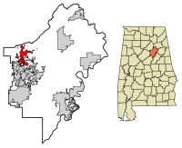
| map= | | map=[[File:Springville locator map.png|200px]] | ||
| locate=Springville | | locate=Springville | ||
}} | }} | ||
'''Springville''' is a town of 4, | '''Springville''' is a town of 4,786 on 6.4 square miles on [[U.S. Highway 11]] in western [[St Clair County]]. | ||
Springville was | The community which became Springville was known to Native Americans and early American traders in the territory for its mineral springs. A community grew up, usually called '''Big Springs''', with permanents settlement beginning in the early 1810s. A church was established there in [[1817]]. When the community got its first [[Springville Post Office|post office]] in [[1833]], it briefly took the name '''Pinkhill''', before switching to Springville in December [[1834]]. | ||
A schoolhouse, the forerunner of [[Springville High School]], was built in [[1861]]. The [[Alabama Great Southern Railway]] connected Springville to [[Birmingham]] and Chattanooga, Tennessee in [[1870]]. The town was incorporated in December [[1880]]. | |||
On [[January 16]], [[1969]] a [[1969 Springville Depot explosion|major explosion]] resulted when a trail carrying propane tanks derailed near the [[Springfield Depot]], destroying numerous buildings nearby. | |||
The downtown area, which features a notable cast-iron façade on the [[Presley Store]] building, is recognized as a historic district on the [[Alabama Register of Landmarks and Heritage]] and the [[National Register of Historic Places in St Clair County|National Register of Historic Places]]. | |||
Downtown Springville is home to [[Big Springs Park]] and a [[Springville Farmers Market]]. [[Homestead Hollow]] and the [[Big Canoe Creek Nature Preserve]] are located just north of the city. | |||
The town has served as a setting for parts of two feature films, ''[[Verne Miller]]'' ([[1986]]) and ''[[Rustin]]'' ([[2001]]). | The town has served as a setting for parts of two feature films, ''[[Verne Miller]]'' ([[1986]]) and ''[[Rustin]]'' ([[2001]]). | ||
| Line 28: | Line 36: | ||
==References== | ==References== | ||
* Windham, Margaret Frances (1969) ''History of Springville, Alabama, 1969: The Sesquicentennial Anniversary.'' | |||
* {{Foscue-1989}} | * {{Foscue-1989}} | ||
* "[http://en.wikipedia.org/w/index.php?title=Springville,_Alabama Springville, Alabama]". (May 4, 2009) Wikipedia - accessed December 3, 2009 | * "[http://en.wikipedia.org/w/index.php?title=Springville,_Alabama Springville, Alabama]". (May 4, 2009) Wikipedia - accessed December 3, 2009 | ||
* Kaetz, James P. (March 27, 2023) "[https://encyclopediaofalabama.org/article/springville/ Springville]." ''Encyclopedia of Alabama'' - accessed February 12, 2024 | |||
==External links== | ==External links== | ||
Revision as of 16:58, 12 February 2024
| City of Springville | |

| |
| Incorporated | 1880 |
|---|---|
| Population | 4,786 |
| Mayor | Dave Thomas |
| School district | St Clair County School System |
| Government |
Springville City Council |
| Web site | springvillealabama.org |

| |
| Locate with Google Maps | |
Springville is a town of 4,786 on 6.4 square miles on U.S. Highway 11 in western St Clair County.
The community which became Springville was known to Native Americans and early American traders in the territory for its mineral springs. A community grew up, usually called Big Springs, with permanents settlement beginning in the early 1810s. A church was established there in 1817. When the community got its first post office in 1833, it briefly took the name Pinkhill, before switching to Springville in December 1834.
A schoolhouse, the forerunner of Springville High School, was built in 1861. The Alabama Great Southern Railway connected Springville to Birmingham and Chattanooga, Tennessee in 1870. The town was incorporated in December 1880.
On January 16, 1969 a major explosion resulted when a trail carrying propane tanks derailed near the Springfield Depot, destroying numerous buildings nearby.
The downtown area, which features a notable cast-iron façade on the Presley Store building, is recognized as a historic district on the Alabama Register of Landmarks and Heritage and the National Register of Historic Places.
Downtown Springville is home to Big Springs Park and a Springville Farmers Market. Homestead Hollow and the Big Canoe Creek Nature Preserve are located just north of the city.
The town has served as a setting for parts of two feature films, Verne Miller (1986) and Rustin (2001).
Demographics
As of the census of 2000, there were 2,521 people, 990 households, and 767 families residing in the town. The population density was 393.8 people per square mile. There were 1,049 housing units at an average density of 163.8/sq mi. The racial makeup of the town was 91% White and 8% Black or African American.
There were 990 households out of which 34.4% had children under the age of 18 living with them, 62.8% were married couples living together, 11.5% had a female householder with no husband present, and 22.5% were non-families. 20.5% of all households were made up of individuals and 8.3% had someone living alone who was 65 years of age or older. The average household size was 2.55 and the average family size was 2.93.
In the town the population was spread out with 24.9% under the age of 18, 6.9% from 18 to 24, 30.1% from 25 to 44, 26.2% from 45 to 64, and 11.9% who were 65 years of age or older. The median age was 38 years. For every 100 females there were 97.4 males. For every 100 females age 18 and over, there were 88.5 males.
The median income for a household in the town was $43,397, and the median income for a family was $53,859. Males had a median income of $35,977 versus $25,542 for females. The per capita income for the town was $20,518. About 8.0% of families and 10.8% of the population were below the poverty line, including 11.1% of those under age 18 and 23.4% of those age 65 or over.
| St Clair County | |
|---|---|
| Topics | |
| Cities |
Argo | Ashville (seat) | Leeds | Margaret | Moody | Odenville | Pell City (seat) | Ragland | Riverside | Springville | Steele | Trussville | Vincent |
References
- Windham, Margaret Frances (1969) History of Springville, Alabama, 1969: The Sesquicentennial Anniversary.
- Foscue, Virginia O. (1989) Place Names in Alabama. Tuscaloosa: University of Alabama Press. ISBN 081730410X
- "Springville, Alabama". (May 4, 2009) Wikipedia - accessed December 3, 2009
- Kaetz, James P. (March 27, 2023) "Springville." Encyclopedia of Alabama - accessed February 12, 2024
External links
- Springville website