Frank Hewitt Bridge: Difference between revisions
m (Typo) |
No edit summary |
||
| (8 intermediate revisions by 2 users not shown) | |||
| Line 1: | Line 1: | ||
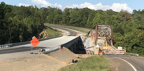
The ''' | [[Image:Buckshort_bridges_in_North_Jefferson_County.jpg|right|thumb|600px|Old & new bridges in 2018]] | ||
The '''Frank A. Hewitt Bridge''' (also called '''Buckshort Bridge''', '''Buck Short Bridge''' or the '''Locust Fork River Bridge''' (AL 12678) is a riveted steel truss bridge carrying [[Mount Olive Road]] ([[Jefferson County Road 77]]) over the [[Locust Fork River|Locust Fork]] of the [[Warrior River]] just above [[White's Creek]], north of [[Mount Olive]] and west of [[Morris]]. The bridge's primary span is 238 feet, while the total length of the bridge deck is about 600 feet. | |||
The bridge was dedicated in [[1955]] in honor of [[Frank Hewitt]], a former member of the [[Jefferson County Board of Revenue]] and [[Jefferson County Treasurer]] who died in [[1943]]. In [[1982]] the [[Jefferson County Public Works Department]] estimated that it would cost $1.3 million to repair deteriorating supports under the bridge. An alternative plan, to move the superstructure to new supports constructed a few feet away and reroute the approaches, cost about $520,000. The move was made in July of that year. | The bridge was dedicated in [[1955]] in honor of [[Frank Hewitt]], a former member of the [[Jefferson County Board of Revenue]] and [[Jefferson County Treasurer]] who died in [[1943]]. | ||
In [[1982]] the [[Jefferson County Public Works Department]] estimated that it would cost $1.3 million to repair deteriorating supports under the bridge. An alternative plan, to move the superstructure to new supports constructed a few feet away and reroute the approaches, cost about $520,000. The move was made in July of that year. | |||
In 2016, construction began on a new bridge to replace the 1955 structure. The new bridge was completed and opened to traffic in August [[2018]]. The new bridge was constructed just upstream of the old bridge. It is also wider, with 12-foot wide lanes and 10-foot shoulders, providing a 44-foot driving surface, versus the 28-foot width of the old bridge. The old bridge was subsequently demolished and removed from the site. | |||
==References== | ==References== | ||
* "[http://news.google.com/newspapers?id=OjMdAAAAIBAJ&sjid=f6UEAAAAIBAJ&pg=5970%2C1534052 Bridge will be shifted]" (June 7, 1982) ''The Tuscaloosa News'' | * "[http://news.google.com/newspapers?id=OjMdAAAAIBAJ&sjid=f6UEAAAAIBAJ&pg=5970%2C1534052 Bridge will be shifted]" (June 7, 1982) ''The Tuscaloosa News'' | ||
* Davis, Rachel (February 24, 2016) "Buckshort Bridge deemed obsolete, scheduled to be replaced" {{NJN}} | |||
==External links== | ==External links== | ||
{{Locate | lat = 33.74415 | lon=-86.91816 | zoom=14 | type=h}} | {{Locate | lat = 33.74415 | lon=-86.91816 | zoom=14 | type=h}} | ||
* [http://bridgehunter.com/al/jefferson/12678/ Frank A. Hewitt Bridge] on bridgehunter.com | * [http://bridgehunter.com/al/jefferson/12678/ Frank A. Hewitt Bridge] on bridgehunter.com | ||
[[Category:Bridges]] | [[Category:Bridges]] | ||
[[Category:Mount Olive Road]] | [[Category:Mount Olive Road]] | ||
[[Category:Locust Fork]] | [[Category:Locust Fork River]] | ||
[[Category:1955 buildings]] | [[Category:1955 buildings]] | ||
Latest revision as of 11:34, 26 October 2023
The Frank A. Hewitt Bridge (also called Buckshort Bridge, Buck Short Bridge or the Locust Fork River Bridge (AL 12678) is a riveted steel truss bridge carrying Mount Olive Road (Jefferson County Road 77) over the Locust Fork of the Warrior River just above White's Creek, north of Mount Olive and west of Morris. The bridge's primary span is 238 feet, while the total length of the bridge deck is about 600 feet.
The bridge was dedicated in 1955 in honor of Frank Hewitt, a former member of the Jefferson County Board of Revenue and Jefferson County Treasurer who died in 1943.
In 1982 the Jefferson County Public Works Department estimated that it would cost $1.3 million to repair deteriorating supports under the bridge. An alternative plan, to move the superstructure to new supports constructed a few feet away and reroute the approaches, cost about $520,000. The move was made in July of that year.
In 2016, construction began on a new bridge to replace the 1955 structure. The new bridge was completed and opened to traffic in August 2018. The new bridge was constructed just upstream of the old bridge. It is also wider, with 12-foot wide lanes and 10-foot shoulders, providing a 44-foot driving surface, versus the 28-foot width of the old bridge. The old bridge was subsequently demolished and removed from the site.
References
- "Bridge will be shifted" (June 7, 1982) The Tuscaloosa News
- Davis, Rachel (February 24, 2016) "Buckshort Bridge deemed obsolete, scheduled to be replaced" North Jefferson News
External links
- Frank A. Hewitt Bridge on bridgehunter.com
