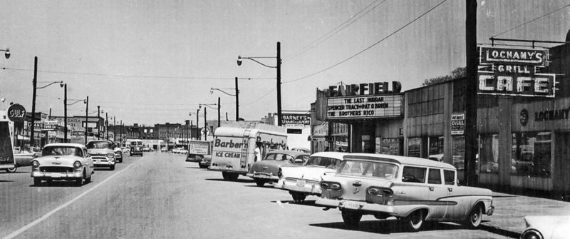
Gary Avenue: Difference between revisions
(Created page with "center|thumb|800px|1959 view of Gary Avenue '''Gary Avenue''' is a major thoroughfare through downtown Fairfield, part of the street pa...") |
|||
| Line 7: | Line 7: | ||
==Notable addresses== | ==Notable addresses== | ||
* avenue begins | |||
* [[41st Street Ensley]] intersects | |||
** 4109: [[3D Foodmart]] / [[Mobil]] gas station, formerly [[M & N Foodmart]] | |||
* [[42nd Street Ensley]] intersects | |||
** 4202: [[Diary African Braid Boutique]] | |||
** 4219: [[Big Moe Spring & Alignment]] | |||
* [[43rd Street Ensley]] intersects | |||
** 4301: [[Sparkle Learning Center]] | |||
** 4318: [[Extreme Auto Detail]] | |||
* [[44th Street Ensley]] intersects | |||
** 4407: [[Tasty Jamaica]] | |||
** 4412: [[Kay Bags Plus]] | |||
** 4416: [[Greekwood Monogram]] | |||
** 4420: [[Nedra's Unlimited HairCare]] | |||
* [[45th Street Ensley]] intersects | |||
** 4502: [[African International Market]] | |||
** 4505: [[Trucks & Trucks Law]] | |||
** 4506: [[Birmingham Islamic Center]]'s [[West Side Masjid]] (2010–) | ** 4506: [[Birmingham Islamic Center]]'s [[West Side Masjid]] (2010–) | ||
* [[North Plaza]] intersects (southeast only) | * [[North Plaza]] intersects (southeast only) | ||
| Line 12: | Line 29: | ||
* [[Crawford Street]] intersects (northwest only) | * [[Crawford Street]] intersects (northwest only) | ||
* [[South Plaza]] intersects (southeast only) | * [[South Plaza]] intersects (southeast only) | ||
** | ** 4601: [[Church of The Reconciler]], former location of [[First Bank of Corey]] / [[Hotel Plaza]] (built 1910) | ||
** 4604: [[Carmichael Building]], former location of [[Fairfield City Hall]] | ** 4604: [[Carmichael Building]], former location of [[Fairfield City Hall]] | ||
** 4607: former location of [[Fairfield First National Bank Branch]], [[AmSouth Bank]] | ** 4607: former location of [[Fairfield First National Bank Branch]], [[AmSouth Bank]] | ||
** 4610: [[Magic City Grill]] | |||
** 4615: [[Walter J. Hanna Public Library]] | ** 4615: [[Walter J. Hanna Public Library]] | ||
* [[47th Street Ensley]] intersects | |||
** 4701: [[Fairfield City Council]] | |||
** 4702: [[Beauty Land]] | |||
** 4705: [[Escapes N Travel]] | |||
** 4714: [[Glorious Touch Alterations]] | |||
* [[48th Street Ensley]] intersects | * [[48th Street Ensley]] intersects | ||
** 4801: [[Restoration Academy]] high school | ** 4801: [[Restoration Academy]] high school | ||
** 4806: [[Gildra's House of Style]] | |||
* [[49th Street Ensley]] intersects | * [[49th Street Ensley]] intersects | ||
** former location of [[A & P]] (1950–) | ** 4901: [[Payless Drugs]], former location of [[A & P]] (1950–) | ||
* [[50th Street Ensley]] intersects | * [[50th Street Ensley]] intersects | ||
** 5003: [[Capstone Counseling Center]] / [[Neo Jazz School of Music]] | ** 5003: [[Capstone Counseling Center]] / [[Neo Jazz School of Music]] | ||
Revision as of 10:14, 30 July 2020
Gary Avenue is a major thoroughfare through downtown Fairfield, part of the street pattern planned by the Tennessee Coal, Iron & Railroad Company in 1909, and named in honor of Elbert Gary, the first president of TCI's parent company, U.S. Steel.
Gary Avenue runs southwest as a continuation of Avenue E Ensley, which also becomes Lloyd Noland Parkway as it passes below I-20/59. Gary Avenue and Lloyd Noland Parkway split between 40th Street Ensley and 41st Street Ensley, with Gary bending westward and crossing Opossum Creek before entering Fairfield's business district. The street proceeds southwest, then turns to the south at 47th Street Ensley, terminating at Valley Road / Donald Parkway. Formerly the section of Valley Road continuing to E. J. Oliver Boulevard was also addressed as Gary Avenue.
The Birmingham Railway, Light & Power Company's No. 5 Ensley-Fairfield streetcar line ran down Gary Avenue, and that service continues as MAX Transit Route 5.
Notable addresses
- avenue begins
- 41st Street Ensley intersects
- 4109: 3D Foodmart / Mobil gas station, formerly M & N Foodmart
- 42nd Street Ensley intersects
- 43rd Street Ensley intersects
- 4301: Sparkle Learning Center
- 4318: Extreme Auto Detail
- 44th Street Ensley intersects
- 4407: Tasty Jamaica
- 4412: Kay Bags Plus
- 4416: Greekwood Monogram
- 4420: Nedra's Unlimited HairCare
- 45th Street Ensley intersects
- 4502: African International Market
- 4505: Trucks & Trucks Law
- 4506: Birmingham Islamic Center's West Side Masjid (2010–)
- North Plaza intersects (southeast only)
- Fairfield Memorial Park (built 1910)
- Crawford Street intersects (northwest only)
- South Plaza intersects (southeast only)
- 4601: Church of The Reconciler, former location of First Bank of Corey / Hotel Plaza (built 1910)
- 4604: Carmichael Building, former location of Fairfield City Hall
- 4607: former location of Fairfield First National Bank Branch, AmSouth Bank
- 4610: Magic City Grill
- 4615: Walter J. Hanna Public Library
- 47th Street Ensley intersects
- 4701: Fairfield City Council
- 4702: Beauty Land
- 4705: Escapes N Travel
- 4714: Glorious Touch Alterations
- 48th Street Ensley intersects
- 4801: Restoration Academy high school
- 4806: Gildra's House of Style
- 49th Street Ensley intersects
- 4901: Payless Drugs, former location of A & P (1950–)
- 50th Street Ensley intersects
- 5003: Capstone Counseling Center / Neo Jazz School of Music
- 5004: former location of Gary Theatre (1924)
- 5005–5007: former location of Fairfield Theatre (1950s)
- 51st Street Ensley intersects
- 5104: Stephen Smith Fine Art (2016–), former location of Fairfield Theatre (1920s)
- 52nd Street Ensley intersects
- 5224: former location of Piggly Wiggly (1925)
