Seal of Alabama: Difference between revisions
No edit summary |
|||
| (8 intermediate revisions by the same user not shown) | |||
| Line 5: | Line 5: | ||
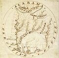
When Mississippi was granted its statehood in [[1817]], President James Monroe appointed Georgia senator [[William Bibb]] to serve as [[Governor of Alabama|Governor]] of the new [[Alabama Territory]]. On [[February 16]], [[1818]] Bibb sent a letter to Secretary of State John Q. Adams requesting that the department furnish his office with an official seal with which to impress official documents. In his letter, Bibb suggested that the seal take the former of, "a Map of the Territory with its principal rivers," and included an ink and watercolor illustration of his suggested design. | When Mississippi was granted its statehood in [[1817]], President James Monroe appointed Georgia senator [[William Bibb]] to serve as [[Governor of Alabama|Governor]] of the new [[Alabama Territory]]. On [[February 16]], [[1818]] Bibb sent a letter to Secretary of State John Q. Adams requesting that the department furnish his office with an official seal with which to impress official documents. In his letter, Bibb suggested that the seal take the former of, "a Map of the Territory with its principal rivers," and included an ink and watercolor illustration of his suggested design. | ||
Bibb's design highlighted ten of the state's principal rivers, naming them as the Tennessee, Tombigby, Black Warrior, Alabama, Cahaba, Coosie, Tallapoosie, Chattahoochie, Perdido and Escambia. The map also suggested hundreds of unlabeled tributary streams as well as Mobile Bay and the shoals of the Tennessee. The label for the Tennessee river was shown upside-down, as if to be read from the north. A textured band represented the "dividing ridge" between the Tennessee and Tombigbee basins and a dotted line extended eastward from a circle at the northwest corner of Washington County (both lines referenced in the 1805 Choctaw cession). The other borders of the territory were also indicated by dotted lines. The territories of the Cherokees and Creeks were labeled, as well as the Spanish territory of East Florida south of the 31st parallel. Symbols on the map showed the locations of five U.S. forts (Ft Hampton, St Stephens, Ft Stoddert, Mobile, Ft Mims), as well as the Spanish Ft San Carlos de Barrancas in Pensacola, Florida. Another symbol, labeled "French" shows the location of the congressionally-sanctioned "Vine and Olive Colony" at present-day Demopolis. A north arrow appears on the west bank of the upper Coosa River. The border of the circular seal bore the words "Alabama Executive Office". | |||
Adams' chief clerk, Daniel Brent, commissioned engraver Moritz Fürst to produce a metal seal to | Adams' chief clerk, Daniel Brent, commissioned engraver Moritz Fürst to produce a metal seal to Bibb's specifications, and forwarded the design illustration to him, along with a note suggesting various changes, on [[April 17]]. Fürst completed his work and sent an impression made by his seal along with an invoice for $450, as well as Bibb's illustration and the note about changes, to Brent. Once the United States paid the invoice, the seal die was conveyed to Bibb at the territorial capital of St Stephens. The other documentation was collected with Brent's papers in the National Archives. | ||
The earliest known impression of the new executive seal is preserved on a February 15, 1819 proclamation certifying Bibb's appointment of [[Bolling Hall]] to serve as Clerk of the Superior Court for Autauga County ([https://digital.archives.alabama.gov/digital/collection/voices/id/5415 link]). A high-resolution scan of the document's embossed seal performed by the [[Alabama Department of Archives and History]] reveals some of the changes made to | The earliest known impression of the new executive seal is preserved on a February 15, 1819 proclamation certifying Bibb's appointment of [[Bolling Hall]] to serve as Clerk of the Superior Court for Autauga County ([https://digital.archives.alabama.gov/digital/collection/voices/id/5415 link]). A high-resolution scan of the document's embossed seal performed by the [[Alabama Department of Archives and History]] reveals some of the changes made to Bibb's illustration in Mürtz's final die. The spelling of the rivers were modified to Tennessee, Tombeckbee, Tusksloosa, Alabama, Cahaba, Coosa, Tallapoosa, Chattahoochee, Perdido and Escambia. The designation for Cherokee lands was removed, and the illustration's lettering was replaced by engraved upper-case letters in the Baskerville face common in printed federal documents. | ||
The territorial seal was adopted as the State of Alabama's official seal by the first [[Alabama State Legislature]] in December [[1819]]. From the 1830s to the mid 1860s the seal was often embossed into gold colored foil circles with a serrated edges and affixed to documents with red wax. | The territorial seal was adopted as the State of Alabama's official seal by the first [[Alabama State Legislature]] in December [[1819]]. From the 1830s to the mid 1860s the seal was often embossed into gold colored foil circles with a serrated edges and affixed to documents with red wax. After [[1852]] custodianship of the seal was transferred from the Governor to the [[Alabama Secretary of State|Secretary of State]]. The Secretary of State is charged with affixing it to official documents and executive records (those signed by the Governor). | ||
<gallery> | |||
File:1818 Bibb illustration.jpg|Bibb's 1818 illustration for the seal | |||
File:1818 Alabama Executive Office seal.jpg|Scan of the imprint made by Moritz Fürst's seal on an 1819 document | |||
</gallery> | |||
==Unofficial emblem== | ==Unofficial emblem== | ||
Though never formally adopted by executive order or state law, an unofficial emblem representing the state came into common use before the 1840s. The oldest-known surviving example of that emblem appeared on the title page of an 1846 schoolbook on U.S. history. The emblem was described in 1880 as, "a rude outline map of the State displayed on a tree, without legend or motto." | Though never formally adopted by executive order or state law, an unofficial emblem representing the state came into common use before the 1840s. The oldest-known surviving example of that emblem appeared on the title page of an 1846 schoolbook on U.S. history. The emblem was described in 1880 as, "a rude outline map of the State displayed on a tree, without legend or motto." | ||
That emblem remained in use after Alabama seceded from the United States and joined the Confederate States of America, appearing in various forms on uniform buttons for the state militia, and on paper currency issued by the state. | That emblem remained in use after Alabama seceded from the United States and joined the Confederate States of America, appearing in various forms on uniform buttons for the state militia, and on paper currency issued by the state. | ||
<gallery> | |||
Image:1817 Alabama seal button.jpg|tree emblem on a state militia uniform button, c. 1860 | |||
Image:1817 Alabama seal 20.png|tree emblem on a Confederate 50¢ note issued 1863 | |||
File:Rebel States Alabama envelope.jpg|tree emblem on an anti-confederate envelope | |||
Image:1817 Alabama seal WPA.png|tree emblem depicted in a 1941 WPA booklet | |||
</gallery> | |||
==1868 seal== | ==1868 seal== | ||
The design was replaced with a new seal on [[December 29]], [[1868]]. The wording of Act 1868-133 was as follows: | The design was replaced with a new seal on [[December 29]], [[1868]]. It is believed that [[Alabama Secretary of State]] [[Charles Miller]] suggested the change. The design with an American eagle and shield emphasized the state's readmission into the United States after the Civil War. The wording of Act 1868-133 was as follows: | ||
<blockquote><i>The seal is in the form of a circle, and two and a quarter inches in diameter; near the edge is the word 'ALABAMA' and opposite, at the same distance from the edge, are the words 'GREAT SEAL.' In the centre of the seal an eagle is represented with raised wings alighting upon the national shield, with three arrows in his left talon. The eagle holds in his beak a streamer, on which immediately over the wings are the words 'HERE WE REST.' The crest-word, which give name to the State, signifies "The land of rest."< | <blockquote><i>The seal is in the form of a circle, and two and a quarter inches in diameter; near the edge is the word 'ALABAMA' and opposite, at the same distance from the edge, are the words 'GREAT SEAL.' In the centre of the seal an eagle is represented with raised wings alighting upon the national shield, with three arrows in his left talon. The eagle holds in his beak a streamer, on which immediately over the wings are the words 'HERE WE REST.' The crest-word, which give name to the State, signifies "The land of rest."</i></blockquote> | ||
<gallery> | |||
Image:1868 Alabama seal.jpg|1868 seal | |||
Image:1868 Alabama seal BW.jpg|engraved version of 1868 seal | |||
Image:1868 Alabama seal 1876.png|version of the 1868 seal in an 1876 lithograph | |||
Image:1868 Alabama seal variant.jpg|variant of 1868 seal without border | |||
Image:1868 Alabama seal WPA.png|1868 seal depicted in a 1941 WPA booklet | |||
</gallery> | |||
==1939 seal== | ==1939 seal== | ||
In [[1939]], at the request of Governor [[Frank Dixon]], the original concept of a map design was returned to use. The new seal was adopted during a special session by Act No. 39-20. The wording of that law was as follows: | In [[1939]], at the request of state archives director [[Marie Bankhead Owen]] and Governor [[Frank Dixon]], the original concept of a map design was returned to use. The new seal was adopted during a special session by Act No. 39-20. The wording of that law was as follows: | ||
<blockquote><i>The seal shall be circular, and the diameter thereof two and a quarter inches; near the edge of the circle shall be the word "Alabama," and opposite this word, at the same distance from the edge, shall be the words, "Great Seal." In the center of the seal there shall be a representation of a map of the state with its principal rivers. The seal shall be called the "Great Seal of the State of Alabama." The seal shall be kept and used as required by the Constitution and laws. | <blockquote><i>The seal shall be circular, and the diameter thereof two and a quarter inches; near the edge of the circle shall be the word "Alabama," and opposite this word, at the same distance from the edge, shall be the words, "Great Seal." In the center of the seal there shall be a representation of a map of the state with its principal rivers. The seal shall be called the "Great Seal of the State of Alabama." The seal shall be kept and used as required by the Constitution and laws.</i></blockquote> | ||
The use of stars in the border, the specific design of the letterforms and the map image, and the labeling of adjacent states and the Gulf of Mexico are not described in the law. In use, the design differs from | The use of stars in the border, the specific design of the letterforms and the map image, and the labeling of adjacent states and the Gulf of Mexico are not described in the law. In use, the design differs from Bibb's 1818 seal in many ways. Tributary rivers are omitted. The borders of the state are indicated by heavy lines, and the adjoining states of Mississippi, Tennessee, Georgia and Florida are clearly labeled, as is the Gulf of Mexico, which is shaded by a hatch of wavy lines. The named rivers are shown as the Tennessee, Tombigbee, Black Warrior, Alabama, Cahaba, Coosa, Tallapoosa, Conecuh and Pea. The border rivers (Escambia and Chattahoochee) have been shown on some versions, but are not indicated in the widely adopted seal. No other symbols for territories, forts, colonies or mountain ranges appear on the seal. | ||
Though the law does not mention coloration, and embossed seals would not convey any color, a color version of the seal has also been in long use. Typically Alabama is highlighted in a maize yellow color with Tennessee in violet, Mississippi in scarlet, Florida in scarlet or brown, and Georgia in dark green. A lighter blue color is used for the gulf waters. | Though the law does not mention coloration, and embossed seals would not convey any color, a color version of the seal has also been in long use. Typically Alabama is highlighted in a maize yellow color with Tennessee in violet, Mississippi in scarlet, Florida in scarlet or brown, and Georgia in dark green. A lighter blue color is used for the gulf waters. | ||
<gallery> | <gallery> | ||
Image:Alabama Great Seal BW.png|line drawing of 1939 seal | Image:Alabama Great Seal BW.png|line drawing of 1939 seal | ||
Image:1939 Alabama seal WPA.png|1939 seal depicted in a 1941 WPA booklet | File:1939 seal pasteup design.jpg|Pasted-up design of the 1939 seal for a 1941 WPA booklet | ||
Image:1939 Alabama seal WPA.png|Colored 1939 seal as depicted in a 1941 WPA booklet | |||
File:Bronze seal of Alabama.jpg|Seal of Alabama cast in bronze | |||
Image:Alabama Great Seal Natl Cathedral.jpg|seal in the narthex of the National Cathedral | Image:Alabama Great Seal Natl Cathedral.jpg|seal in the narthex of the National Cathedral | ||
Image:Alabama Great Seal.png| | Image:Alabama Great Seal.png|Alabama Great Seal in color | ||
</gallery> | </gallery> | ||
==See also== | ==See also== | ||
| Line 69: | Line 69: | ||
==External links== | ==External links== | ||
* [ | * [https://archives.alabama.gov/emblems/great_sl.html Alabama Emblems: Great Seal] at archives.alabama.gov | ||
* [http://www.sos.state.al.us/OfficeOfSoS/Default.aspx Office of the Secretary] at sos.state.al.us | * [http://www.sos.state.al.us/OfficeOfSoS/Default.aspx Office of the Secretary] at sos.state.al.us | ||
Latest revision as of 14:46, 27 March 2021

The Seal of Alabama or Alabama Great Seal is the official seal used by the State of Alabama on official proclamations and commissions.
1818 seal
When Mississippi was granted its statehood in 1817, President James Monroe appointed Georgia senator William Bibb to serve as Governor of the new Alabama Territory. On February 16, 1818 Bibb sent a letter to Secretary of State John Q. Adams requesting that the department furnish his office with an official seal with which to impress official documents. In his letter, Bibb suggested that the seal take the former of, "a Map of the Territory with its principal rivers," and included an ink and watercolor illustration of his suggested design.
Bibb's design highlighted ten of the state's principal rivers, naming them as the Tennessee, Tombigby, Black Warrior, Alabama, Cahaba, Coosie, Tallapoosie, Chattahoochie, Perdido and Escambia. The map also suggested hundreds of unlabeled tributary streams as well as Mobile Bay and the shoals of the Tennessee. The label for the Tennessee river was shown upside-down, as if to be read from the north. A textured band represented the "dividing ridge" between the Tennessee and Tombigbee basins and a dotted line extended eastward from a circle at the northwest corner of Washington County (both lines referenced in the 1805 Choctaw cession). The other borders of the territory were also indicated by dotted lines. The territories of the Cherokees and Creeks were labeled, as well as the Spanish territory of East Florida south of the 31st parallel. Symbols on the map showed the locations of five U.S. forts (Ft Hampton, St Stephens, Ft Stoddert, Mobile, Ft Mims), as well as the Spanish Ft San Carlos de Barrancas in Pensacola, Florida. Another symbol, labeled "French" shows the location of the congressionally-sanctioned "Vine and Olive Colony" at present-day Demopolis. A north arrow appears on the west bank of the upper Coosa River. The border of the circular seal bore the words "Alabama Executive Office".
Adams' chief clerk, Daniel Brent, commissioned engraver Moritz Fürst to produce a metal seal to Bibb's specifications, and forwarded the design illustration to him, along with a note suggesting various changes, on April 17. Fürst completed his work and sent an impression made by his seal along with an invoice for $450, as well as Bibb's illustration and the note about changes, to Brent. Once the United States paid the invoice, the seal die was conveyed to Bibb at the territorial capital of St Stephens. The other documentation was collected with Brent's papers in the National Archives.
The earliest known impression of the new executive seal is preserved on a February 15, 1819 proclamation certifying Bibb's appointment of Bolling Hall to serve as Clerk of the Superior Court for Autauga County (link). A high-resolution scan of the document's embossed seal performed by the Alabama Department of Archives and History reveals some of the changes made to Bibb's illustration in Mürtz's final die. The spelling of the rivers were modified to Tennessee, Tombeckbee, Tusksloosa, Alabama, Cahaba, Coosa, Tallapoosa, Chattahoochee, Perdido and Escambia. The designation for Cherokee lands was removed, and the illustration's lettering was replaced by engraved upper-case letters in the Baskerville face common in printed federal documents.
The territorial seal was adopted as the State of Alabama's official seal by the first Alabama State Legislature in December 1819. From the 1830s to the mid 1860s the seal was often embossed into gold colored foil circles with a serrated edges and affixed to documents with red wax. After 1852 custodianship of the seal was transferred from the Governor to the Secretary of State. The Secretary of State is charged with affixing it to official documents and executive records (those signed by the Governor).
Bibb's 1818 illustration for the seal
Scan of the imprint made by Moritz Fürst's seal on an 1819 document


Unofficial emblem
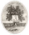
Though never formally adopted by executive order or state law, an unofficial emblem representing the state came into common use before the 1840s. The oldest-known surviving example of that emblem appeared on the title page of an 1846 schoolbook on U.S. history. The emblem was described in 1880 as, "a rude outline map of the State displayed on a tree, without legend or motto."
That emblem remained in use after Alabama seceded from the United States and joined the Confederate States of America, appearing in various forms on uniform buttons for the state militia, and on paper currency issued by the state.
tree emblem on a state militia uniform button, c. 1860
tree emblem on a Confederate 50¢ note issued 1863

tree emblem on an anti-confederate envelope

tree emblem depicted in a 1941 WPA booklet


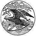
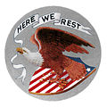
1868 seal
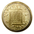
The design was replaced with a new seal on December 29, 1868. It is believed that Alabama Secretary of State Charles Miller suggested the change. The design with an American eagle and shield emphasized the state's readmission into the United States after the Civil War. The wording of Act 1868-133 was as follows:
The seal is in the form of a circle, and two and a quarter inches in diameter; near the edge is the word 'ALABAMA' and opposite, at the same distance from the edge, are the words 'GREAT SEAL.' In the centre of the seal an eagle is represented with raised wings alighting upon the national shield, with three arrows in his left talon. The eagle holds in his beak a streamer, on which immediately over the wings are the words 'HERE WE REST.' The crest-word, which give name to the State, signifies "The land of rest."

1868 seal
engraved version of 1868 seal
version of the 1868 seal in an 1876 lithograph
variant of 1868 seal without border

1868 seal depicted in a 1941 WPA booklet


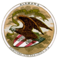
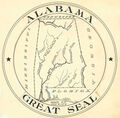
1939 seal
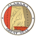
In 1939, at the request of state archives director Marie Bankhead Owen and Governor Frank Dixon, the original concept of a map design was returned to use. The new seal was adopted during a special session by Act No. 39-20. The wording of that law was as follows:
The seal shall be circular, and the diameter thereof two and a quarter inches; near the edge of the circle shall be the word "Alabama," and opposite this word, at the same distance from the edge, shall be the words, "Great Seal." In the center of the seal there shall be a representation of a map of the state with its principal rivers. The seal shall be called the "Great Seal of the State of Alabama." The seal shall be kept and used as required by the Constitution and laws.
The use of stars in the border, the specific design of the letterforms and the map image, and the labeling of adjacent states and the Gulf of Mexico are not described in the law. In use, the design differs from Bibb's 1818 seal in many ways. Tributary rivers are omitted. The borders of the state are indicated by heavy lines, and the adjoining states of Mississippi, Tennessee, Georgia and Florida are clearly labeled, as is the Gulf of Mexico, which is shaded by a hatch of wavy lines. The named rivers are shown as the Tennessee, Tombigbee, Black Warrior, Alabama, Cahaba, Coosa, Tallapoosa, Conecuh and Pea. The border rivers (Escambia and Chattahoochee) have been shown on some versions, but are not indicated in the widely adopted seal. No other symbols for territories, forts, colonies or mountain ranges appear on the seal.
Though the law does not mention coloration, and embossed seals would not convey any color, a color version of the seal has also been in long use. Typically Alabama is highlighted in a maize yellow color with Tennessee in violet, Mississippi in scarlet, Florida in scarlet or brown, and Georgia in dark green. A lighter blue color is used for the gulf waters.

line drawing of 1939 seal
Pasted-up design of the 1939 seal for a 1941 WPA booklet
Colored 1939 seal as depicted in a 1941 WPA booklet
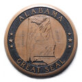
Seal of Alabama cast in bronze
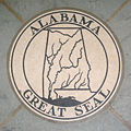
seal in the narthex of the National Cathedral

Alabama Great Seal in color


See also
References
- Preble, George Henry (1880) History of the flag of the United States of America. A. Williams & Company
- Robb, David M. Jr (Fall 2014) "An Invisible Map Revealed: The First State Seal of Alabama." Alabama Heritage No. 114
External links
- Alabama Emblems: Great Seal at archives.alabama.gov
- Office of the Secretary at sos.state.al.us