Norwood
| Norwood | |
| Birmingham neighborhoods | |
| District(s) | 4, 5 |
|---|---|
| Community | Northside |
| Population | 1,636 |
| Area | N/A |
| President | Tom Creger |
| Meeting site | Norwood Community Center, (map) |
| Meeting day | 4th Saturday |
| Website | historicnorwood.com |
| Neighborhood map | Norwood |
Norwood is a neighborhood of Birmingham in the northeast corner of the Northside community, in the "North Highlands" north of downtown.
In the current Birmingham Community Participation Program, Norwood's borders follow an irregular path of creek, roads, and railroad tracks. Village Creek forms the northern border. To the east, the border comes down along the Louisville & Nashville Railroad's track to Interstate 20/59, then follows the interstate west to Vanderbilt Road; it follows that road down to Richard Arrington, Jr Boulevard and back to the east to the railroad and then down to the southern border. The southern border follows 9th Avenue North southwest to 31st Street North, then turns due west until meeting Arrington Boulevard; it follows Arrington briefly before turning due west again across the interstate to meet Carraway Boulevard. Carraway is the western border up to 19th Avenue North. The northwestern border follows 19th Avenue east to the Southern Railroad track, then follows the track NNW back to Village Creek.
History
Norwood was developed by the Birmingham Realty Company beginning in 1910 with B. B. Merriweather as lead surveyor. It was named for Sidney Norwood, a friend of Birmingham Realty president Leslie Fullenweider (no doubt also chosen for its marketing potential). The neighborhood was planned as a streetcar suburb centered on Norwood Boulevard, along the same lines as the development around Highland Avenue in Southside. The central 1.5-mile boulevard's 200-foot right of way included space for the Norwood Streetcar Line as well as broad landscaped park-like medians.
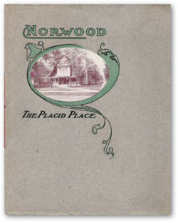
Billed as "The Placid Place", the developers touted the neighborhood's convenience to downtown as well as its removal from the smoke and noise of the city center. Other amenities promised by the marketers included "gracious neighbors", fully integrated utility services, and modern architecture. Houses sprang up along the boulevard almost before it was completed, including "Tennessee Row", a group of homes built by families hailing from Tennessee.
As large houses were being constructed on the boulevard, other development followed. The Realty Company erected a commercial building with a grocery store, meat market and dairy. The neighborhood was chosen by Charles Carraway in 1916 as the site for what came to be known as Norwood Hospital before it was renamed for him. In 1925 the Norwood School was constructed.
Nevertheless, the beginnings of the neighborhood's slow, steady decline began in the 1930s as automobile ownership made it possible for affluent families to move out of Jones Valley altogether. The developers of Mountain Brook and other "Over the Mountain" suburbs advertised larger homesites absolutely free from the smoke and haze of the city. The second wave of homebuyers in Norwood included Jewish, Greek and Italian families who did not have access to the society of the neighborhood's pioneers. After World War II, cheaper cars and social insecurity in the wake of school integration combined to spur white flight from Birmingham proper. Some residents blamed real estate companies for fomenting fears of the neighborhood's decline in order to profit from the rapid turnover. Meanwhile others reported threats made against families interested in selling their homes by residents trying to keep African Americans from moving in.
Birmingham's segregation laws and zoning codes were overturned by federal actions in the 1960s, at the same time that construction of I-20/59 was proceeding through downtown. Many of the middle-class African American families displaced by the highway looked to Norwood as an attractive destination. Institutions like the Norwood Community Ministry, Operation Pride, and the city's Norwood Park, which made attempts to integrate new and old residents with social, housing improvement, and recreational programs, became targets for reactionaries who associated Blacks and federal programs with the loss of their accustomed way of life. The highway also served to create a barrier between the neighborhood and downtown while the growth of the Birmingham Municipal Airport added noise to the list of ills borne by residents, presenting what the Birmingham News magazine In Dixieland termed an "urban crisis" in 1969.
In recent years young homebuyers have mounted a renewal of the neighborhood, newly-appreciated for its architectural quality and convenience to downtown. In 2006 students from the Auburn University Urban Studio met with the Norwood Neighborhood Association to prepare a long-range comprehensive physical plan for the area. The association, headed by Mary Jean LaMay, meets on the fourth Saturday of each month at the Norwood Community Center on 28th Street North.
A Norwood Resource Center was established in the Robert Nygren residence to assist homeowners with restoring and maintaining the neighborhood's historic architecture. The center also offers internet access, health and financial counseling and other programs for residents.
Presidents
- Robert Gilmore
- Mary Jean LaMay 2014-2016
- Tom Creger, 2016-
Demographics
- 2010: 2,536 (93.7% Black)
- 2020: 1,636 (87.3% Black)
References
- "The Urban Crisis... as seen in the story of Birmingham's Norwood" (December 7, 1969) In Dixieland (Birmingham News magazine) - via Birmingham Public Library Digital Collections
- Kemp, Kathy (January 29, 2006) "Reviving grandeur: Once-elegant northside neighborhood attracts renovating newcomers." The Birmingham News
- Kemp, Kathy (September 9, 2007) "Old houses, new hope in Norwood." The Birmingham News
- Ruisi, Anne (June 24, 2009) "Committee in Birmingham's historic Norwood Neighborhood hangs banners at community entrances." The Birmingham News
- "Residents on the Picturesque, Charm, and Opportunities of Norwood" (January 20, 2022) The Birmingham Times
External links
- Historic Norwood website
- "Norwood: The Placid Place" at AbandonedSoutheast.com
