Kimberly: Difference between revisions
No edit summary |
|||
| Line 46: | Line 46: | ||
{{Jefferson County}} | {{Jefferson County}} | ||
[[Category:Kimberly|*]] | [[Category:Kimberly|*]] | ||
[[Category:1951 establishments]] | |||
Revision as of 10:37, 12 June 2010
| Town of Kimberly | |
| Incorporated | 1951 |
|---|---|
| Population | 1,801 |
| Mayor | Craig Harris |
| School district | Jefferson County Schools |
| Government |
Kimberly Town Council |
| Web site | kimberlyal.org |

| |
| Locate with Google Maps | |
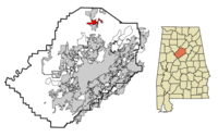
Kimberly (incorporated in 1951) is a town of 1,801 located on 4 square miles along U.S. Highway 31 in northern Jefferson County between Warrior and Morris, 17 miles north of Birmingham.
The Mayor of Kimberly is Craig Harris, who assumed office after Ralph Lindsey retired in April 2009. The town council meets at Kimberly Town Hall on Stouts Road. The city of Kimberly has only seven full-time employees, including four police officers. The chief of police is James Belding. The city has 16 other part-time employees.
Kimberly students attend Jefferson County Schools: John E. Bryan Elementary School, North Jefferson County Middle School, which is in Kimberly, and Mortimer Jordan High School.
Kimberly's ZIP code is 35091. The primary telephone exchanges in Kimberly, which is in the 205 area code, are 590 and 647.
History
The community was originally little more than a stage coach station and tavern on Bear Creek Cabin Road called Kennelsville. The station, opened by Jack Gill, was operated by the Davenport family until 1865, when Stouts Road was completed.
The community later took the name Jefferson after the Jefferson coal seam which was mined from there in the 1880s. The Jefferson Mine, a vertical shaft mine, was closed in 1888 and the Jefferson Post Office moved to nearby Kinderville. Residents of Jefferson successfully lobbied to restore post service in 1901. Because a Marengo County community had taken the name Jefferson, a new name was needed. Milton Doss suggested "Kimberly" as a reference to the diamond mining district of South Africa.
Interstate 65 runs west of Kimberly and while there is no direct access to it within the city, exits 280 to the north and 275 to the south both list it. Before this final segment of I-65 was completed in 1985, travelers heading south were forced to exit the interstate at exit 280 and travel on Highway 31 through Kimberly on their way to Birmingham.
The town is currently home to four churches: Mount Zion Baptist Church, Kimberly Church of God, Kimberly United Methodist Church, and North Creek Community Church.
Demographics
As of the census of 2000, there were 1,801 people, 652 households, and 528 families residing in the town. The population density was 447.8/mi². There were 699 housing units at an average density of 173.8/mi². The racial makeup of the town was 96% White. 1.2% of the population were Hispanic or Latino of any race.
There were 652 households, of which 42.2% had children under the age of 18 living with them, 68.3% were married couples living together, 9.5% had a female householder with no husband present, and 18.9% were non-families. 17.0% of all households were made up of individuals and 8.4% had someone living alone who was 65 years of age or older. The average household size was 2.76 and the average family size was 3.11.
In the town the population was spread out with 29.3% under the age of 18, 6.7% from 18 to 24, 33.1% from 25 to 44, 20.5% from 45 to 64, and 10.5% who were 65 years of age or older. The median age was 34 years. For every 100 females there were 99.4 males. For every 100 females age 18 and over, there were 91.6 males.
The median income for a household in the town was $46,343, and the median income for a family was $52,109. Males had a median income of $36,977 versus $29,150 for females. The per capita income for the town was $17,055. About 6.7% of families and 7.7% of the population were below the poverty line, including 9.6% of those under age 18 and 15.8% of those age 65 or over.
The Jefferson County Board of Equalization evaluated 783 homes in Kimberly and determined that their average market value for 2007 was $143,637, a 6.9% increase since 2006.
References
- Kimberly, Alabama. (January 16, 2007). [1] Wikipedia, The Free Encyclopedia. Accessed 22:19, January 16, 2007.
- Foscue, Virginia O. (1989) Place Names in Alabama. Tuscaloosa: University of Alabama Press. ISBN 081730410X
- Kimberly, Alabama. (n.d.) [2] City-data.com. Accessed January 16, 2007
External links
- Kimberly official website
| Jefferson County | |
|---|---|
| Topics |
Communities | County Commission | Courts | Schools | Sheriff |
| Cities |
Adamsville | Bessemer (seat) | Birmingham (seat) | Brighton | Brookside | Cardiff | Center Point | Clay | Fairfield | Fultondale | Gardendale | Graysville | Homewood | Hoover | Hueytown | Irondale | Kimberly | Leeds | Lipscomb | Maytown | Midfield | Morris | Mountain Brook | Mulga | North Johns | Pinson | Pleasant Grove | Sylvan Springs | Tarrant | Trafford | Trussville | Vestavia Hills | Warrior | West Jefferson |