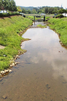
Shades Creek
Shades Creek, sometimes called Mountain Brook, is a 56.4 mile-long stream running southwest from its source near the Birmingham Race Course, through Shades Valley, to the Cahaba River near the Shelby County/Bibb County line. Along the way it passes through Irondale, Birmingham, Mountain Brook, Homewood, Hoover, and Bessemer.
History

According to an interactive map at the University of Alabama[1], much of Shades Creek acted as the border between Jefferson and Shelby Counties until sometime between 1880 and 1890, when the border was moved south to roughly its current location.
From 1915 to the 1940s, Shades Creek was dammed at Columbiana Road, just downstream of Griffin Creek to form Edgewood Lake, a popular recreational resort during the 1920s and 30s.
Some time in the 1940s or 50s a bridge-dam was created across the creek near the Bibb County / Shelby County line by sinking six railroad box cars into the bed. The railcars posed a hazard for recreational users and were removed in 2010 and 2011 with funding provided by the US Fish and Wildlife Service.
In recent years, the Freshwater Land Trust has purchased several acres of land along the creek, primarily behind Wildwood Shopping Center and in Shannon for permanent conservation. The Land Trust is also working to remove privet, a highly invasive, non-native plant, along stretches of Shades Creek in Bessemer and to restore the creek to its original pathway. Other work along the creek includes Homewood's construction of the Shades Creek Greenway to connect Jemison Park in Mountain Brook with West Homewood Park.
A dam across the Cahaba just downstream of its confluence with Shades Creek is thought to have negatively impacted water quality in both streams. In 2006, biologists found Cahaba shiners, goldline darters and coal shiners in Shades Creek for the first time. A year later the fish were found in five locations and single specimens of two types of mussel, the elephant ear mussel and the fine-lined pocketbook mussel, were also found.
With indications that the stream is healthier than once thought, the outlook is promising for the removal of the boxcar dam. The issue is being studied by the U. S. Fish and Wildlife Service.
In February 2009 an oily film was reported on the creek surface. Workers for the Alabama Department of Environmental Management traced the source to a storm drain in the Crestline neighborhood and installed boom floats to contain the film. No evidence of harm to wildlife was found.
In early 2011 Samford University completed a project to improve a 1,200-foot section of the creek which will adjoin its new track and outdoor recreational facility. The project was aimed at correcting erosion issues on the stream banks and restoring native plantings to better nurture aquatic life.
Tributaries
Starting upstream (from the north):
- Crestline Tributary
- Furnace Branch
- Watkins Brook
- Griffin Brook
- Scott's Branch
- Little Shades Creek
- Rice Creek
- Clear Branch
- Bob George Branch
- Black Creek
- Mud Creek
- Roupe's Creek
Sites along Shades Creek
Starting upstream (from the north):
- Jemison Park
- Brookwood Village
- Shades Creek Greenway
- Homewood High School
- University Park
- Wildwood Shopping Center
- Camp Fletcher
- Tannehill Ironworks Historical State Park
Streets running alongside Shades Creek
Major roads crossing Shades Creek
Starting upstream (from the north):
- Crestwood Boulevard
- Interstate 20
- U.S. Highway 280
- Independence Drive (U.S. Highway 31)
- Columbiana Road
- Interstate 65
- West Oxmoor Road
- State Highway 150
- Interstate 459
References
- Cahaba Tributaries at the Rivers of Alabama web site
- Greenway Walking Trail at the Homewood Chamber of Commerce web site
- Freshwater Land Trust web site. Accessed September 8, 2019.
- Bouma, Katherine (November 19, 2006) "Imperiled fish reappear up Shades Creek." Birmingham News.
- Bouma, Katherine (April 30, 2008) "Discovery of mussels suggests Shades Creek healthier than believed in Birmingham area, biologists say." Birmingham News
- Thornton, William (February 27, 2009) "Shades Creek greasy film traced to stormwater drain in Birmingham but source is mystery." Birmingham News
- Singleton, William C. (January 19, 2011) "Samford University restores part of Shades Creek in Homewood." Birmingham News
- White, Marjorie L. "Shades Creek - Flowing Through Time" published by the Birmingham Historical Society in 2019.