Block 86: Difference between revisions
No edit summary |
|||
| (One intermediate revision by the same user not shown) | |||
| Line 1: | Line 1: | ||
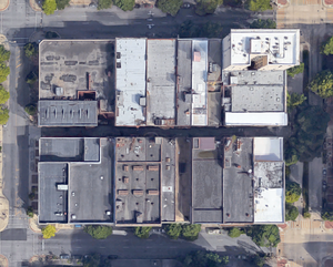
[[File:Block 86 gmap.png|right|thumb| | [[File:Block 86 gmap.png|right|thumb|300px|2020 Google Maps aerial view of Block 86]] | ||
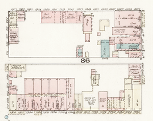
[[File:1911 Sanborn block 86.png|right|thumb| | [[File:1885 Sanborn block 86.png|right|thumb|300px|1885 Sanborn map detail of Block 86]] | ||
[[File:1911 Sanborn block 86.png|right|thumb|300px|1911 Sanborn map detail of Block 86]] | |||
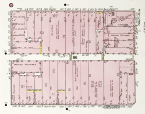
[[File:1929 tax map Block 86.jpg|right|thumb|300px|1929 tax map detail of Block 86]] | |||
'''Block 86''' is a [[Birmingham]] [[Birmingham city center street grid|city block]] bordered by [[19th Street North|19th]] and [[20th Street North|20th Streets]] and by [[2nd Avenue North|2nd]] and [[3rd Avenue North|3rd Avenue]]s North in the heart of [[downtown Birmingham]]. It is bisected from east to west by [[2nd Alley North]]. | '''Block 86''' is a [[Birmingham]] [[Birmingham city center street grid|city block]] bordered by [[19th Street North|19th]] and [[20th Street North|20th Streets]] and by [[2nd Avenue North|2nd]] and [[3rd Avenue North|3rd Avenue]]s North in the heart of [[downtown Birmingham]]. It is bisected from east to west by [[2nd Alley North]]. | ||
| Line 16: | Line 18: | ||
* [[20th Street North]] | * [[20th Street North]] | ||
** 200-206: [[Roden Block]] (built | ** 200-206: [[Roden Block]] (built 1885) | ||
** 208–210: [[208-210 20th Street North]] (built 1900s) | ** 208–210: [[208-210 20th Street North]] (built 1900s) | ||
** 212: [[Iron Age building]] (built 1886) | ** 212: [[Iron Age building]] (built 1886) | ||
| Line 25: | Line 27: | ||
* [[2nd Avenue North]] | * [[2nd Avenue North]] | ||
** 1900–1902: [[1900 Building]] (built 2005), former location of [[Peerless Saloon]] (built 1889, demolished 2003) | ** 1900–1902: [[1900 Building]] (built 2005), former location of [[Peerless Saloon]] (built 1889, demolished 2003) | ||
** 1904-1906: [[Silver's Building]] (built c. | ** 1904-1906: [[Silver's Building]] (built c. 1922) | ||
** 1908: [[1908 2nd Avenue North]] | ** 1908: [[1908 2nd Avenue North]] | ||
** 1910-1914: [[Old Kress Building]] (built 1915) | ** 1910-1914: [[Old Kress Building]] (built 1915) | ||
| Line 32: | Line 34: | ||
** 1920–1922: [[Ferd Marx]] (built c. 1899) | ** 1920–1922: [[Ferd Marx]] (built c. 1899) | ||
** 1924-1926: [[Caheen Building]] (built c. 1904) | ** 1924-1926: [[Caheen Building]] (built c. 1904) | ||
** 1928-1930: [[Roden Block]] (built | ** 1928-1930: [[Roden Block]] (built 1885) | ||
* [[3rd Avenue North]] | * [[3rd Avenue North]] | ||
Latest revision as of 15:45, 8 July 2021
Block 86 is a Birmingham city block bordered by 19th and 20th Streets and by 2nd and 3rd Avenues North in the heart of downtown Birmingham. It is bisected from east to west by 2nd Alley North.
In 1900 the north side of the block was described as, "occupied by one-story buildings used for negro restaurants, barber shops, etc.". By 1910 it had been built up into a solid row of three-story commercial buildings with the 9-story Farley Building occupying the corner of 20th Street.
By 1920 the circuit around Block 86 had become a well-known pedestrian route, passing the highest volume of shops and therefore maximizing the opportunity to encounter friends and acquaintances. It was popularly called the "racetrack" or the "Chicken Run". During the Great Depression circling the "chicken run" continued as a popular way to wile away idle hours.
Notable buildings
- 19th Street North
- 201-207: 1900 Building (built 2005), former location of Peerless Saloon (built 1889, demolished 2003)
- 209–211: 211 Building
- 213-215: Taylor Building (built 1890)
- 217-225: California Fashion Mall (built 1939 for F. W. Woolworth), former location Simon Block (built 1886, demolished 1938)
- 20th Street North
- 200-206: Roden Block (built 1885)
- 208–210: 208-210 20th Street North (built 1900s)
- 212: Iron Age building (built 1886)
- 214–216: 214-216 20th Street North (built 1905)
- 218: 218 20th Street North (built 1904)
- 220–222: Farley Building (built 1909)
- 2nd Avenue North
- 1900–1902: 1900 Building (built 2005), former location of Peerless Saloon (built 1889, demolished 2003)
- 1904-1906: Silver's Building (built c. 1922)
- 1908: 1908 2nd Avenue North
- 1910-1914: Old Kress Building (built 1915)
- 1916: 1916 2nd Avenue North
- 1918: 1918 2nd Avenue North
- 1920–1922: Ferd Marx (built c. 1899)
- 1924-1926: Caheen Building (built c. 1904)
- 1928-1930: Roden Block (built 1885)
- 3rd Avenue North
- 1901–1909: California Fashion Mall (built 1939 for F. W. Woolworth)
- 1901–1903: former location of Simon Block (built 1886, demolished 1938)
- 1905: former location of Slayton & Mauldin saloon (1899, demolished before 1939)
- 1907–1909: former location of 1907–1909 3rd Avenue North (demolished before 1939)
- 1911–1913: Brown & Jacobs Building (built c. 1900s)
- 1915–1917: Odum, Bowers & White (built c. 1899 for Kress)
- 1919–1921: Gilbert Trunk Factory
- 1921: former location of Maggie Bracken's brothel (1880s)
- 1923: Bonita Theater (built 1906)
- 1925–1931: Farley Building (built 1909)
- 1901–1909: California Fashion Mall (built 1939 for F. W. Woolworth)


