Elton B. Stephens Expressway: Difference between revisions
m (Renaming categories) |
Patriarca12 (talk | contribs) m (→History) |
||
| Line 16: | Line 16: | ||
When the expressway was originally constructed, a cloverleaf exit was constructed at [[1st Avenue North]] for southbound traffic. An on-ramp was constructed over the cloverleaf and used in the 1970s, but later removed. Currently, although the cloverleaf exit exists, it is closed to traffic. | When the expressway was originally constructed, a cloverleaf exit was constructed at [[1st Avenue North]] for southbound traffic. An on-ramp was constructed over the cloverleaf and used in the 1970s, but later removed. Currently, although the cloverleaf exit exists, it is closed to traffic. | ||
In the months leading to [[1996]] [[Olympic soccer]] to be hosted in [[Legion Field]], | In the months leading to [[1996]] [[Olympic soccer]] to be hosted in [[Legion Field]], the [[Olympic soccer countdown clock]] was located on the [[Highland Avenue South]] overpass. | ||
==Exit Listing== | ==Exit Listing== | ||
Revision as of 15:56, 24 October 2006
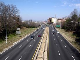
The Elton B. Stephens Expressway, more commonly referred to locally as the Red Mountain expressway, is a limited access freeway serving as a north-south connection between Homewood and Mountain Brook south of Red Mountain with I-20/I-59 just to the northeast of downtown Birmingham. It was named for local businessman and philanthropist Elton B. Stephens.
The freeway generally carries three lanes for travel in each direction and carries traffic for both Highway 31 and Highway 280. Between its northern terminus and University Boulevard, the freeway is elevated. From University Boulevard to its southern terminus the freeway is by and large at-grade.
Termini
The southern terminus of the expressway is where Highway 31 and Highway 280 split in Homewood at Rosedale Drive. From this point Highway 31 becomes Montgomery Highway and continues in a southerly direction through Homewood, Vestavia Hills, Hoover and points beyond as it exits the Birmingham region. Highway 280 remains as a divided highway as it travels in a southeasterly direction through Mountain Brook, Vestavia Hills, Hoover, Calera and points beyond as it exits the Birmingham region.
At its northern terminus, Highway 280 arrives at its western terminus, whilst Highway 31 continues as Carraway Boulevard through Birmingham and continues its northerly track through Fultondale, Gardendale, Morris, Kimberly, and Warrior and points beyond as it exits the Birmingham region.
History
Construction commenced in 1962 with the initial blasting of the Red Mountain cut. The cut was completed in 1967 with the highway opening in 1970.
Originally ending at 2nd Avenue North, its connection with I-20/I-59 and Carraway Boulevard was completed in the 1980s over the site of Birmingham’s grand Terminal Station demolished in 1969.
When the expressway was originally constructed, a cloverleaf exit was constructed at 1st Avenue North for southbound traffic. An on-ramp was constructed over the cloverleaf and used in the 1970s, but later removed. Currently, although the cloverleaf exit exists, it is closed to traffic.
In the months leading to 1996 Olympic soccer to be hosted in Legion Field, the Olympic soccer countdown clock was located on the Highland Avenue South overpass.
Exit Listing
| Northbound Exit | Number of Lanes | Southbound Exit | Number of Lanes |
|---|---|---|---|
| Rosedale Drive | 2 | Highway 78/3rd Avenue South/4th Avenue South | 3 |
| Highland Avenue South/Arlington Avenue South | 3 | University Boulevard | 3 |
| University Boulevard | 4 | 21st Avenue South/Vulcan Park | 3 |
| Highway 78/3rd Avenue South/4th Avenue South | 3 | Highway 31 South | 4 |
| Highway 11/1st Avenue North | 3 | Mountain Brook/Birmingham Zoo | 4 |
| 2nd Avenue North | 4 | ||
| Carraway Boulevard/I-20/I-59 | 4 |
