April 27, 2011 tornado outbreak
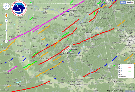
The April 27, 2011 tornado outbreak was part of a major tornado outbreak which affected the Southern, Midwestern, and Eastern United States between April 25–28, 2011, leaving catastrophic destruction in its wake, especially across the state of Alabama. The outbreak produced destructive tornadoes in Alabama, Arkansas, Georgia, Mississippi, North Carolina, Tennessee, and Virginia, and affected several other areas throughout the Southern and Eastern United States with tornadoes confirmed from Texas to New York. Widespread and destructive tornadoes occurred on each day of the outbreak, with April 27 being the most prolific and destructive tornado day in United States history, surpassing the 1974 Super Outbrake.
On the morning of April 27, a quasi-linear convective system moved across the state causing wind damage in several locations. That same afternoon, a major outbreak of violent supercell storms spawned scores of tornados across Alabama and neighboring states. A total of 62 tornados were documented in the state on that day, five of which were rated as EF-4 or stronger on the "Enhanced Fujita Scale". At around 5:10 p.m. CDT a very large and exceptionally destructive tornado struck Tuscaloosa. About 40 minutes later, the same tornado struck the northern suburbs of Birmingham. A tornado emergency was issued for both cities. A debris ball was observed by the Birmingham NEXRAD, indicating that the tornado was causing extreme damage. Photos from the damage path showed total devastation.
Before April 2011, the record number of tornadoes reported in the state in one calendar day was 36, occurring during the November 2001 tornado outbreak on Thanksgiving Day. That record was broken when 45 tornadoes touched down during the April 15, 2011 tornado outbreak, then surpassed again with 62 tornadoes on April 27. The three EF-5 tornadoes which reached Alabama on that day increased the number of such massive twisters that had visited the state since 1874 from 6 to 9. Five of the 10 longest tornado tracks ever recorded in the world were laid down across Alabama on April 27.
By the morning of April 30, the Alabama Emergency Management Agency had confirmed at least 45 storm fatalities in Tuscaloosa. A statewide review by emergency management officials has recorded 249 fatalities statewide, either directly or indirectly attributable to the storms. According to the August 26 final report of data collected by the National Weather Service from various agencies, there were 139 deaths directly related to the April 27 outbreak, second only tho the 270 deaths which were caused by the 1932 tornado outbreak. Of those 139, 86 occurred in permanent structures, 46 in manufactures homes, 2 in vehicles and 2 outdoors. In July, the Insurance Information Institute said the total of estimates made by insurance companies in the Birmingham and Tuscaloosa areas came to $2 billion. There have been approximately 165,000 home, auto and business claims in those areas resulting from the outbreak. Statewide insured losses were estimated at between $2.6 and $4.2 billion. A University of Alabama study concluded that the storms caused $228.4 million in property damage, destroying 7,300 structures and damaging another 15,700. Meanwhile, the economic impact of recovery efforts was calculated at around $3.2 billion.
EF-4 tornadoes
Tuscaloosa/Birmingham tornado
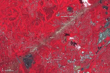
A large wedge tornado tracked across Tuscaloosa County including the southern and eastern portions of Tuscaloosa around 5:10 p.m. on April 27, and continued northeast. Debris from the tornado was reported to be falling from the sky across Birmingham over 20 miles away. Skycams operated by WBRC and ABC affiliate WJSU captured video of the tornado as it struck Tuscaloosa. Several stores and restaurants in a business district at the intersection of McFarland Boulevard and 15th Street, near the DCH Regional Medical Center, were destroyed by the tornado; buildings were also reported destroyed on 35th Street, between Interstate 359 and Martin Luther King Jr. Boulevard. As the tornado traveled east to 35th Street and Kauloosa Avenue, the Tuscaloosa Environmental Services and Cintas facilities suffered severe damage. Numerous homes in the Rosedale and Forest Lake neighborhoods, as well as a P&P Grocery and Rosedale Court, were devastated. The University of Alabama suspended its operations, canceled its softball and rowing competitions, canceled its final exams period, and postponed its commencement until August 6.
The tornado entered Jefferson County from the southwest in a rural area before ripping through Concord killing six residents and destroying nearly the entire community. From Concord, the storm continued in its northeasterly path towards Pleasant Grove. Devastating much of the central portion of the community, nine residents were killed in Pleasant Grove as a result of the storm. From there, the tornado continued through McDonald Chapel en route to the Pratt City area of Birmingham where two residents were killed and the Pratt City Library heavily damaged. The tornado continued towards the northeast causing significant damage in Fultondale before retracting back into the sky. The storm moved through northeast Jefferson County without causing significant damage before the tornado touched-down in St. Clair County just south of Ashville where it continued moving to the northwest through east Alabama and west Georgia. Television cameras, including another skycam operated by WJSU, captured the mile-wide tornado as it moved east-northeast across the western and northern areas of Jefferson County around 6:00 p.m. CDT.
The National Weather Service determined the path length of this violent tornado to be 80.3 miles with a maximum damage path width of 1.5 miles; it has been preliminary classified as an EF-4 tornado with peak winds up to 190 mph. Initial reports from Tuscaloosa and Birmingham indicated at least 59 people were killed, with over 1,000 injured in the Tuscaloosa area alone. This makes the storm the deadliest tornado in the United States since 1955, and the deadliest single tornado ever to strike the state of Alabama. President Barack Obama and First Lady Michelle Obama visited Tuscaloosa on April 29, taking a ground tour of some of the affected areas along 15th Street, in Alberta City and Holt. Obama was quoted as saying that he has "never seen devastation like this." He stated further that he had already declared a federal state of emergency in Alabama retroactive to the day of the storm.
As of the evening of May 2, 326 people remained missing in Tuscaloosa. According to the Los Angeles Times, "no sooner are names stricken than fresh reports flow in to swell the list again." Reports on May 3 indicated that throughout Tuscaloosa County, nearly 400 people were missing. Search and rescue efforts throughout the area continued with four cadaver dogs and 100 personnel combing the rubble. According to the Alabama Emergency Management Agency, eight others are missing elsewhere in the state. By May 5, the number of missing people in Tuscaloosa decreased to 12.
Cullman/Arab tornado
The tornado was first seen and then tracked on tower cameras, including one operated by WJSU, for several minutes. Some cameras were obliterated. Radio stations in downtown Cullman also reported in on the tornado and some even captured the tornado passing over until their broadcast towers were destroyed. Preliminary reports stated that the courthouse and EMS building nearby took a direct hit. Many well-known businesses such as Vincent's furniture, the Cullman Times, and the Busy Bee Cafe were severely damaged or destroyed. There was major damage was along a two block area through the center of the downtown business district. This tornado continued northeast and swept away a gas station in Arab along with completely crippling its power grid and obstructing many roads with trees. Six total fatalities were reported from this tornado.
EF-3 tornadoes
Parrish/Cordova tornado
This tornado spun up along a shear axis in rural southwestern Walker County east of Alabama Highway 69 and south of County Road 6. It rapidly intensified and caused major damage to a home, leaving a foundation swept clean on Horseshoe Bend. The tornado continued north-northeast through the Richardson subdivision and across Pleasantville Road, destroying at least two single-wide manufactured homes. In the Aldridge community, several homes were damaged, large trees were uprooted, and another single-wide manufactured home was tossed and obliterated. In Cordova, the tornado caused significant roof and parapet damage to brick buildings in the downtown area. The tornado crossed Old U.S. Highway 78 just east of the Mulberry Fork, snapping and uprooting trees, and continued northeast just south of County Road 22 before dissipating less than a mile north of U.S. Highway 78.
The damage path was 19 miles long and approximately 300 yards wide at its widest point.[1] Although rated EF-3 at its worst with winds of at least 140 miles per hour, the majority of the damage surveyed rated the tornado as EF-1.
Holman tornado
Winds for this tornado were estimated to be around 140 miles per hour. The tornado touched down south of U. S. Highway 82 in far eastern Pickens County, where many hardwood trees were uprooted. The tornado crossed into Tuscaloosa County near Holman, where the path width grew to 400 yards and numerous trees were uprooted. The tornado continued northeast, causing extensive damage to a home as the roof was removed and tossed 200 yards. A 3500 pound trailer was also thrown 100 yards. Along its path, the tornado snapped or uprooted thousands of trees, with many homes sustaining damage from falling trees. At least 3 outbuildings or barns were also damaged or destroyed. The tornado lifted 2.5 miles east northeast of Samantha along North Hagler Road where several trees were uprooted.[2]
The total length of the tornado's track was 22.4 miles with a maximum width of 600 yards. No deaths or injuries were associated with it.
Coaling tornado
Winds for this tornado were estimated up to 155 miles per hour. The tornado touched down just southwest of Coaling off Staghorne Drive. Tree damage was noted in this area. The tornado then moved northeast and paralleled Interstate 20/59 where several homes sustained significant damage and a few were completely destroyed. Tornado damage here was consistent with EF-3 damage. The tornado continued northeast where the Mercedes-Benz US International assembly plant sustained roof damage and power poles were blown down, along with numerous trees snapped. The tornado continued to snap trees as it moved northeast into far southwest Jefferson County where it ended at Old Tuscaloosa Highway and Lowetown Road.[3]
Sawyerville-Eoline tornado
A strong tornado touched down in far southwest Greene County near the Tombigbee River just west of Tishabee on County Road 69 near Head Drive, and headed northeast across rural Greene County north of Forkland. At least four mobile homes, three outbuildings, and two churches were damaged or destroyed along with numerous trees. Two minor injuries were noted in Greene County. The track started as an EF-1 but increased to an EF-2 rating while in Greene County. The tornado then crossed the Black Warrior River and moved into Hale County passing through Sawyerville and northeast into the Talladega National Forest. Numerous mobile homes and single family homes, one church, and countless trees were damaged or destroyed. There were 40 injuries and six fatalities across Hale County. The track increased from an EF-2 to an EF-3 while in Hale County just northeast of Sawyerville. The tornado then crossed into southwest Bibb County in the Talladega National Forest and moved northeast to Eoline and ended in Marvel. Several mobile homes and single family homes, one business, as well as the Eoline Fire Station, and countless trees were damaged or destroyed. There were eight injuries and one fatality in Bibb County. EF-3 and EF-2 damage was noted for the most part in Eoline and central Bibb County then decreased in intensity as it moved into northeast rural Bibb County toward Marvel.[4]
The tornado's track extended 71.3 miles with a maximum width of one mile. Maximum winds were estimated at 145 miles per hour.
EF-2 tornadoes
Cahaba Heights tornado
The tornado first touched down as category EF-0 near Gresham Elementary School. From there it quickly strengthened to EF-1 and moved northeast across U.S. Highway 280 into Cahaba Heights. Estimated winds just northeast of Highway 280 were estimated at 120 m.p.h., giving the tornado its EF-2 rating. However, the majority of the track had estimated winds of 95–105 m.p.h., making it EF-1 for most of its 7.9-mile long track. The maximum width was 200 yards.
The tornado eventually crossed Interstate 459 before lifting near Grants Mill Road just east of the Liberty Park area. Hundreds of trees were snapped and uprooted, many of them landing on homes causing significant damage. The highest amount of damage was in Cahaba Heights just west of the elementary school north of U.S. Highway 280, where numerous homes sustained significant damage from fallen trees.[5]
Odenville tornado
Much of the damage in St Clair County was due to straight line winds, but the National Weather Service determined a tornado struck near Odenville, leaving a track 3.9 miles long and a maximum of 200 yards wide. The tornado touched down in a field just southeast of the intersection of Alabama Highway 174 and Isbell Road. From there it quickly strengthened to EF-2 intensity and struck two multi-story brick homes. One house lost a large portion of its roof deck material. The well built detached garage of the other house was shifted off its foundation, with the intact roof landing and squashing the remaining structure. The tornado continued northeast before lifting near the intersection of Pleasant Valley Road and Cedar Road where a few trees were blown down.[6]
EF-1 tornadoes
Altadena tornado
During the first wave of severe weather a tornado struck the Altadena area in extreme northern Shelby County and southern Jefferson County between 5:50 and 5:55 a.m. Maximum winds were estimated up to 100 mph. It touched down in far northern Shelby County, less than one mile west of the intersection of Valleydale Road and Caldwell Mill Road, and tracked northeastward into southern Jefferson County. Numerous trees were knocked down which caused damage to homes, apartment buildings, vehicles and power lines. The tornado crossed into Jefferson County just east of the intersection of Caldwell Mill Rd and Pahokee Trace. The tornado weakened to an EF=0 rating and produced tree damage until it lifted near the intersection of Acton Place and Caldwell Mill Rd. The damage path was 3.39 miles long and 100 yards wide at its widest point.[7]
Marvel tornado
During the second wave of severe weather, a tornado struck Marvel extending from far northeast Bibb County into extreme southwest Shelby County between 7:30 and 7:40 p.m. It was a regeneration of a supercell that had struck Wateroak (Hale County) earlier. Maximum winds were estimated around 105 mph. The tornado touched down in northeast Bibb County in a forested area just west of the intersection of County Roads 65 and 10. It then traveled northeast snapping off dozens off pine trees. The tornado lifted in a grassy field just north of County Road 10 in Shelby County, between Blossom Street and Springbrook Lane. The damage path was 5.41 miles long and 50 yards wide at its widest point.[8]
Vincent-Logan Martin tornado
During the second wave of severe weather, a tornado struck in the vicinity of Vincent in Shelby County and Logan Martin Dam in Talladega County between 8:15 and 8:25 p.m. It was a second regeneration of the Wateroak and Marvel supercell. Maximum winds were estimated around 105 mph. The tornado touched down south of the town of Vincent on County Road 62, in Shelby County, where it uprooted dozens of trees. The tornado traveled to the northeast and dropped trees along the path. As it continued to the northeast into Talladega County, the tornado caused tree damage on the east end of Logan Martin Dam and continued through a couple of residential neighborhoods. Here, the tornado snapped and uprooted hardwood and softwood trees. The only home damage found and surveyed was due to fallen trees on Shaw Lane alongside Logan Martin Lake. The damage path was 8.59 miles long and 200 yards wide at its widest point.[9]
References
- April 2011 Tornado Damage Imagery from the NOAA - accessed May 9, 2011
- "2011 Super Outbreak" (May 9, 2011) Wikipedia - accessed May 9, 2011
- Robinson, Carol (April 28, 2011) "Little left of tiny Concord where 6 died". The Birmingham News
- Robinson, Carol (April 28, 2011) "Coroner's office confirms 18 dead in Jefferson County". The Birmingham News
- Morton, Jason (April 29, 2011) "President Obama promises aid, resources" The Tuscaloosa News
- "Historic Tornado Outbreak of April 27, 2011." (May 12, 2011). Weather Forecast Office Birmingham. Accessed May 18, 2011.
- Anderson, Lars (May 23, 2011) "Terror, Tragedy And Hope In Tuscaloosa". Sports Illustrated
- Spencer, Thomas (July 7, 2011) "Alabama tornadoes: Tuscaloosa, Birmingham area storms could cost insurers $2 billion." The Birmingham News
- National Weather Service (August 26, 2011) "Data finalized for the April 2011 historic tornado outbreaks" public information statment - via "The Alabama Weather Blog"
- "Study: April 27 tornadoes caused $228M in damage." (September 13, 2011) Birmingham Business Journal
- Thornton, William (April 27, 2021) "April 27, 2011 tornadoes, moment-by-moment: How it happened" The Birmingham News
External links
- 2011 tornado information from the National Weather Service


