Center Point Parkway
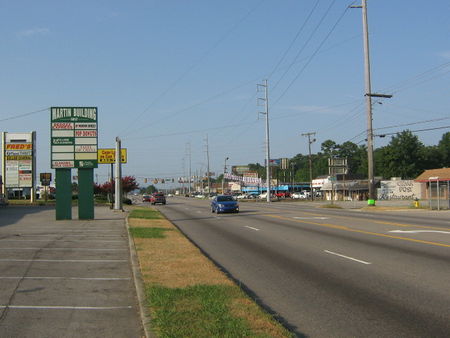
Center Point Parkway is the name of Alabama Highway 75 as it passes northward through Center Point. It begins at approximately 2 miles from Highway 75's intersection with Exit 134 at I-59 (where it starts as Roebuck Parkway and continues northward as Parkway East), at the southern intersection of Huffman Road in Huffman. It is known as Center Point Parkway for approximately 4 miles, and runs through the city limits of Birmingham, Center Point, Pinson, and parts of unincorporated Jefferson County until its intersection with Sweeney Hollow Road in Pinson, where it becomes Center Point Road. At its most southern section, it is 6 lanes wide, narrowing to 4 lanes at approximately around the 1200 block, and continuing as 4 lanes through the heart of Center Point and continuing as Pinson Boulevard. Beginning with the northern intersection of Huffman Road at around 16th Avenue, Center Point Parkway serves as the dividing line between avenues which run east to west. Avenues which continue west from the parkway are labeled "Northwest" and those traveling eastward are labeled "Northeast", with street numbering beginning at 1 in either direction.
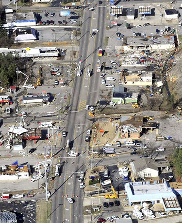
Several businesses in the 2300 and 2400 blocks were damaged or destroyed during the January 2012 tornado outbreak.
Notable locations
- For an alphabetical list of locations, see the Center Point Parkway category.
- parkway crosses over Five Mile Creek, continuing south toward Huffman Road as Parkway East
- 1100: Bama Discount Gas Station / Crazy Bill's
- 1170: Serra Chevrolet, former location of Richard Kelley Chevrolet (1980)
- 1175: Former location of HQ Warehouse
- 1185: Former location of Golden Corral
- 1189: Little Caesar's Pizza / Always Money, former location of Guthrie's (-August 2008) and Boston Market
- 1197: Parkway Cleaners
- Cheyenne Boulevard intersects, east only
- 1201: Serra Hyundai
- 1204: Former location of T-Bones Steaks
- 1206: Fully Uploaded Studio
- 1207: Center Point Motors
- 1215: former location of Birmingham Pool Center / Skinny's Scuba Shack (1985)
- 1216: V2V Gem In the Making
- 1232: Kristian Kane Event Center
- 1238: Friendship Christian Church Ministries
- 1240: Former location of Seafood World
- 1251: AAMCO Transmissions
- 1254: Exotic Wings & Things
- 1255: Precision Collision
- Hiawatha Drive Northeast intersects, west only
- 1263: Church Consultants Inc.
- Winnetka Way Northeast intersects, east only
- 1283: Parkway East Exxon gas station
- 1291: Griddle House
- 13th Avenue Northeast intersects
- 1300: Serra Toyota
- 1301: Onin Staffing
- 13th Court Northeast intersects, west only
- 14th Avenue Northeast intersects, east only (access to Parkway Villa Apartments)
- 1477: Express Loans
- 1480: Cathedral of the Cross Apostolic Overcoming Holy Church of God, former location of Cathedral of the Cross
- Shadowood Circle Northeast intersects, east only
- 1490: Serra Volkswagen
- 1495: Tint Plus
- Lake Drive Northwest/Lake Drive Northeast intersect
- 1500: Serra Nissan
- 1501: Serra Subaru
- 1512: Alliance Financial Resources
- 1516: Picture Perfect Hair Salon
- 1540: Reed Agency
- 1541: Center Point Wholesale Transmission
- 1545: Parkway Finance Company
- 15th Terrace Northeast intersection
- 1575: Tienda Carniceria y Taqueria Fiesta
- 1579: Tony's Mufflers
- 1st Street Northwest / 16th Avenue Northeast intersect
- west side:
- 1600: former location of Bonanza Sirloin Pit restaurant
- 1610: Sherwin-Williams Paint Store
- 1614: Title Cash
- 1636: U-Haul
- 1650: O'Reilly Auto Parts
- 1652: New York Nails
- east side:
- 1601–1629: Eastgate Shopping Center (built 1970)
- 1631: Standard Furniture showroom & service center
- 1641A: former location of Jeans Etc clothing (1985)
- 1649: Quik Pawn Shop
- 1653: KFC
- west side:
- 16th Terrace Northeast intersects, east only
- 1656: Dunnavant Auto Clean (1996–)
- 1660: Smartech
- 1664: Eastern Tire Distributors (1980–)
- 1671–1691: Bruno's Centre (built 1986)
- 17th Avenue Northwest intersects, west only
- 1700: Parkway Motors
- 1701: Former location of Mustang Drive-In (demolished 1986)
- 1710: former location of Big G's Cedar Post Bar-B-Que (1974)
- 1714: former location of The Clothes Tree (Deborah Wiggins 1975–1993)
- 1715: former location of Carousel Carpets & Interiors (Margaret and Carl Stapleton 1975)
- 18th Avenue Northwest intersects, west only
- 1800: Moore Oil Company, Moore Auto Classic Museum
- 1719-1931: Martin Building
- 1719: Lu Lu Wireless/Boost Mobile
- 1725: Alabama Title Loans
- 1727: former location of Village Video & Photography (1985)
- 1805: Taste of China
- 1813: Pop Donuts
- 1817: Hawa African Hair Braiding
- 1819: Swol's Barber Shop
- 1812: NAPA Auto Parts, former location of Tidwell Motors (1974)
- 1825: former location of Braswell's Furniture (1974–1980)
- 1828: Former location of Lovvorn Brothers Cleaners (1946–2007), El Charro Mexican store
- 1830: former location of Stacy's Jeans & Accessories
- 1832: former location of USA Tax Service
- 1834: Total Travel
- 1835: B & W Philly Steaks (Bin Lin 2023–), former location of Taco Bell
- 1837: MetroPCS
- Polly Reed Road intersects, east only
- 1840: El Charro Mexican store, former location of Buster's Fruit Stand (1940s), Gulf service station (1940s-1950s), CBS Recording Studios
- 1844: Dependable Motors
- 1845: Popeye's
- 1849: former location of Pasquale's Pizza & Pasta, Sanford Discount Pharmacy (1981)
- 1852: Premier Auto Wash, former location of Der Wienerschnitzel (1974-1977)
- 1855: TitleBucks
- 1857: An Elegant Affair tuxedo shop, former location of San Marcos taqueria
- 1860: Wing Master, former location of Golden Skillet fried chicken (1975), Whataburger, Long John Silver's, Johnny Ray's, Donato's Pizza
- 19th Avenue Northwest intersection, west only
- 1901: Tobacco Express
- 1904: Pee Wee's Tires, former location of Center Point Union 76 gas station (1974)
- 1907: McDonald's
- 19th Court Northeast intersects, east only
- 1916: Walmart Neighborhood Grocery, formerly Delchamps and Western Supermarket (-1980s)
- 1945: Center Point First Baptist Church
- 20th Avenue Northwest/20th Avenue Northeast intersection
- 2000: CVS Pharmacy, former location of Express Oil Change
- 2007: Advance Auto Parts, former location of Dagwoods Sandwich Shop (1985)
- 2009: former location of The Printer stationers (1974)
- 2013: Express Oil Change & Tire Engineers
- 20th Court Northwest intersects, west only
- 2020: Family Dollar #8978, former location of Exchange-Security Bank (–1975), First Alabama Bank (1975–1983), AmSouth Bank (1983–2006), Regions Bank (2006–)
- 2021: Mattress Plus, former location of Alabama Wholesale Jewelry (Tommy & Ray Owen 1985)
- 2027: Lee's Pawn
- 2032: AutoZone
- 21st Avenue Northwest/21st Avenue Northeast intersection
- 2103: Subway sandwich shop, former location of Ol Baldy's and Mr Good Guy restaurants, Professional Hair Stylist East (Barbara Morgan 1993)
- 2105: Majesty African Hair Braiding
- 2109: former location of The Shoe Trail (1974), PCS Film Shop (1985), Deborah's Clearance Center (Deborah Wiggins 1993)
- 2112: Handy TV & Appliance, former location of Rite-Aid pharmacy
- 2115: Queen's Beauty Supply
- 21st Court Northwest intersects, west only
- 2116: Scott's Tire Outlets
- 2120: Sprint mobile
- 2129: Center Point United Methodist Church
- 22nd Avenue Northwest / 22nd Avenue Northeast intersects
- 2200: Rape & Brooks Orthodontics
- 2204: Center Point Area Chamber of Commerce
- 2208: Waffle House
- 2209: Center Point City Hall / Center Point Head Start Center, formerly Center Point School
- 2229: Center Point Fire District headquarters
- 2233: Center Point Fire Station No. 1 (built 2006)
- 2240: former location of Center Point Fire Station No. 1 (former residence renovated 1967, demolished 2007)
- 2241: Center Point Civitan Park
- 2244: former location of Clyde Echols optometrist (1985)
- 2252: Mike's Quick Stop
- 23rd Avenue Northwest/23rd Avenue Northeast intersect
- west side
- 2300-2366: Center Point Shopping Center (built 1960s)
- 2306: Regions Bank Center Point branch (2006–)
- 2300-2366: Center Point Shopping Center (built 1960s)
- east side
- 2301: Walgreen's pharmacy, former location of Jack's (1960s), Arby's
- 2313: former location of The Burger Shoppe (1985)
- 2321: commercial building
- Suite 100: Simone's Kitchen and Cocktails (Whitney Simone 2024–), former location of karate studio (2008–2013), Vickie Nails (2014–2022),
- 2329-2499 Center Point Plaza shopping center
- 2329: Firestone auto service
- 2331: former location of Bama 6 cinemas (1983-1998), demolished
- 2351: former location of Wells Fargo Bank, SouthTrust branch, destroyed January 2012
- 2405: Green Acres Cafe, former location of Paradise Reef Pets & Supplies (1985)
- 2409: Money Store, former location of Partners Tax & Accounting, McNaughton & Associates
- 2417: Precision Tune Auto Care
- 2421: former location of Imani Church, Check Depot, Nation Wide Security, demolished
- 2429: Chevron gas station
- west side
- 23rd Terrace Northwest intersects, west only
- 24th Avenue Northwest intersects, west only
- 2400: Rally's Hamburgers
- 2408: Sonic Drive-In
- 2424: former location of Wells Fargo Center Point branch (2012-November 2020)
- 2430: Wash It Quick Laundry
- 25th Avenue Northwest/25th Avenue Northeast intersect
- 2500: former location of JYC Insurance (1996)
- 2501: Center Point Foodmart
- 2505: Papa John's Pizza
- 25th Court Northwest/25th Court Northeast intersect
- 26th Avenue Northwest intersects, west only
- 26th Avenue Northeast intersects, east only
- 2630: Uncle Bob's Self Storage
- 2651: Jefferson County Courthouse Center Point Satellite
- 2701-2725: Center Point Softball Park
- Hillview Lane Northwest intersects, west only
- Dogwood Lane Northwest intersects, west only
- Chase Lane Northeast intersects, east only
- Westchester Drive intersects, access to Panorama East Apartments and Valley Brook Apartments
- proposed location of Center Point Hospital (1970s)
- 3100: Center Point Church of the Nazarene
- 3101: Marathon Gas station
- 36th Avenue Northwest intersects, west only
- 36th Avenue Northeast intersects, east only
- 3620: former location of Campbell's Carpets (1990)
- Houston Road Northwest intersects, west only
- Saturn Lane intersects, east only
- Apple Valley Recreation Center (under construction)
- Martin Drive intersects, west only
- parkway continues north through Pinson as Center Point Road

