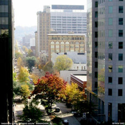
20th Street North: Difference between revisions
| Line 49: | Line 49: | ||
** 407: former location of [[Greenwood's Restaurant]] | ** 407: former location of [[Greenwood's Restaurant]] | ||
** 412: former location of [[Joy Young Restaurant]] | ** 412: former location of [[Joy Young Restaurant]] | ||
** 417: [[Regions Plaza]] | ** 417: [[Regions Plaza]] (formerly AmSouth-Sonat Building) | ||
** 420: [[Wachovia Tower]] | ** 420: [[Wachovia Tower]] (formerly SouthTrust Tower) | ||
** 430: former location of [[Tutwiler Hotel (1914)|Tutwiler Hotel]] | ** 430: former location of [[Tutwiler Hotel (1914)|Tutwiler Hotel]] | ||
* [[5th Avenue North]] intersection | * [[5th Avenue North]] intersection | ||
** [[Regions Center]] | ** [[Charles Ridley]], peanut vendor | ||
** [[Regions Center]] (formerly AmSouth Center) | |||
** 500: former location of [[Southern Club]] and [[Molton Hotel]] | ** 500: former location of [[Southern Club]] and [[Molton Hotel]] | ||
** 502: former location of [[Birmingham Athletic Club]] | ** 502: former location of [[Birmingham Athletic Club]] | ||
** 505: [[Financial Center Building]], ([[Birmingham Regional Chamber of Commerce]], [[Compass Bank]] branch) | ** 505: [[Financial Center Building]], ([[Birmingham Regional Chamber of Commerce]], [[Compass Bank]] branch) | ||
** 529: [[Cathedral Church of the Advent]] | ** 529: [[Cathedral Church of the Advent]] | ||
** 530: [[ | ** 530: [[Regions-Harbert Plaza]] (formerly AmSouth-Harbert Plaza) | ||
* [[6th Avenue North]] intersection | * [[6th Avenue North]] intersection | ||
** [[Birmingham Board of Education]] | ** [[Birmingham Board of Education]] | ||
| Line 64: | Line 65: | ||
** 710: [[Birmingham City Hall]] | ** 710: [[Birmingham City Hall]] | ||
* [[Linn Park]] | * [[Linn Park]] | ||
** [[Birmingham City Hall]] | |||
==References== | ==References== | ||
Revision as of 17:45, 6 December 2007
20th Street North, also known as Birmingham Green, is a north-south street in the center of downtown Birmingham which functions as Birmingham's "main street".
20th Street begins at the northern end of 20th Street South at the Railroad Reservation. From there it first crosses Morris Avenue, and then continues for seven blocks to Park Place where it is terminated by Linn Park.
Birmingham Green was a project covering those seven blocks which was completed in 1973. The project involved removing utility lines below street level and enhancing the street with tree planters, flower beds, and wide sidewalks. Parking on 20th Street is restricted mainly to loading zones. The $5 million cost was paid for by local business owners, as well as local and federal governments.
The street in front of Birmingham City Hall on the west side of Linn Park is called Short 20th Street. It once continued past Municipal Auditorium and the Birmingham Museum of Art to the present site of the Birmingham-Jefferson Convention Complex. After the I-20/59 bridge was built, this section was closed to traffic and eventually converted into a landscaped walk and fountain. There are other short sections of the street in North Birmingham, north of Oak Hill Cemetery and near Finley Boulevard.
Notable Locations (south to north)
For an alphabetical list of locations, see the 20th Street North category.
- Railroad Reservation
- Morris Avenue intersection
- 2: Two North Twentieth building (former Relay House, Linn's Park, and L & N Station)
- 3: Taylor Building (former Elyton Land Company)
- 17: John A. Hand Building, headquarters for Superior Bank
- Woodward Building, headquarters for First American Bank
- 1st Avenue North intersection (Heaviest Corner on Earth)
- Empire Building, Colonial Bank branch (former site of Bank Saloon)
- Brown Marx Building (former site of National Bank of Birmingham building)
- 109: former location of Thompson's Restaurant
- 113: Cafe Dupont
- 117: former location of the King Tut Deli, scheduled to become part of Bromberg's
- 121: New York Style Delicatessen
- 123: Bromberg's
- 124: Webb Building (former site of the Dude Saloon, Yogo's Frosty Frozen Yogurt, Purple Onion, and Pope Jewelers)
- 2nd Avenue North intersection
- 200: Roden Block (Parisian)
- 201: Frank Nelson Building, Birmingham School of Law, A. & A. Ash Jewelers
- 205: Roma's Italian Bistro
- 217: Sojourns
- 218: Quizno's Sub, Classic Basket
- 219: Bon Ton Hatters
- 221: MedTown Pharmacy
- 3rd Avenue North intersection
- 300: Blach's building
- 301: Watts Building, Renasant Bank branch
- 307: former location of Casino Restaurant
- 309: former location of Britling Cafeteria No. 2
- 313: Roly Poly Sandwiches
- 314: former location of Faust Restaurant
- 321: Java and Jams
- 4th Avenue North intersection
- 400: former location of Cafe Italiano
- 400 1/2: former location of Mary Beard's Restaurant
- 404: former studio of A. C. Keily
- 407: former location of Greenwood's Restaurant
- 412: former location of Joy Young Restaurant
- 417: Regions Plaza (formerly AmSouth-Sonat Building)
- 420: Wachovia Tower (formerly SouthTrust Tower)
- 430: former location of Tutwiler Hotel
- 5th Avenue North intersection
- Charles Ridley, peanut vendor
- Regions Center (formerly AmSouth Center)
- 500: former location of Southern Club and Molton Hotel
- 502: former location of Birmingham Athletic Club
- 505: Financial Center Building, (Birmingham Regional Chamber of Commerce, Compass Bank branch)
- 529: Cathedral Church of the Advent
- 530: Regions-Harbert Plaza (formerly AmSouth-Harbert Plaza)
- 6th Avenue North intersection
- Park Place intersection
- 710: Birmingham City Hall
- Linn Park
References
- Birmingham Area Chamber of Commerce (1976) Century Plus: A Bicentennial Portrait of Birmingham, Alabama 1976 Birmingham: Oxmoor Press, p. 16.
External links
- Photographs of 20th Street North from the Magic City Flickr Group

