Linn Park: Difference between revisions
No edit summary |
|||
| Line 2: | Line 2: | ||
[[Image:Linn Park axis 2006.jpg|right|thumb|275px|Linn Park in 2006]] | [[Image:Linn Park axis 2006.jpg|right|thumb|275px|Linn Park in 2006]] | ||
'''Charles Linn Park''' (formerly '''Central Park''', '''Capitol Park''', and '''Woodrow Wilson Park''') was one of three parks included in the [[Elyton Land Company]]'s original plans for [[Birmingham]]. Labeled "Park" on the original plat, it came to be called "Central Park" as it crowned the central sping of [[20th Street North|20th Street]] and lay midway between "East Park" (now [[Marconi Park]]) and "West Park" (now [[Kelly Ingram Park]]). | '''Charles Linn Park''' (formerly '''Central Park''', '''Capitol Park''', and '''Woodrow Wilson Park''') was one of three parks included in the [[Elyton Land Company]]'s original plans for [[Birmingham]], as drafted by [[William Barker]]. Labeled "Park" on the original plat, it came to be called "Central Park" as it crowned the central sping of [[20th Street North|20th Street]] and lay midway between "East Park" (now [[Marconi Park]]) and "West Park" (now [[Kelly Ingram Park]]). | ||
On [[February 21]], [[1883]] the Elyton Company handed over the park's deed to [[Mayor of Birmingham|Mayor]] [[A. O. Lane]] on the condition that the city reimburse the company for the cost of a newly-installed iron fence and for the costs associated with the conveyance, fund public improvements to the property immediately, and agree to relinquish the site to the State should the city succeed in having the capital moved to Birmingham from Montgomery. | |||
By the time the Beers map was printed, the lots surrounding the park were built up with large fashionable houses, many in the ornate and complex Queen Anne style with effusions of brightly-painted wood porches, balconies, turrets, oriels, gables and bays. An obelisk-style [[Confederate Soldiers & Sailors Monument]] was erected between [[1894]] and [[1905]] at the park's southern end. | In [[1886]] [[James Powell]] inserted the name "Capitol Park" into a map being produced by Beers, Ellis and Company for the "[[Atlas of the City of Birmingham and Suburbs]]". The map, published in [[1887]], showed a conjectured T-shaped building just south of the park's center as a stand-in for a future capitol building. Though [[Governor of Alabama|Governor]] [[Joseph Johnston]] briefly conducted state business from a rented store in the city during a yellow fever outbreak in Montgomery, no other steps toward relocating the capital from Montgomery were ever accomplished. | ||
By the time the Beers map was printed, the lots surrounding the park were built up with large fashionable houses, many in the ornate and complex Queen Anne style with effusions of brightly-painted wood porches, balconies, turrets, oriels, gables and bays. A large cast-iron [[Hudgin's fountain|fountain]], donated to the city in the 1880s by [[T. L. Hudgins]], was moved to the park in [[1891]]. An obelisk-style [[Confederate Soldiers & Sailors Monument]] was erected between [[1894]] and [[1905]] at the park's southern end and a [[Mary Cahalan sculpture|monument]] to beloved school teacher [[Mary Cahalan]], sculpted by [[Giuseppi Moretti]], was erected in [[1908]]. The city constructed various curvilinear sidewalks connecting to those points of interest. | |||
[[Image:Confederate Soldiers & Sailors Monument.jpg|left|thumb|225px|The park's [[Confederate Soldiers & Sailors Monument|Confederate Monument]] (1905)]] | [[Image:Confederate Soldiers & Sailors Monument.jpg|left|thumb|225px|The park's [[Confederate Soldiers & Sailors Monument|Confederate Monument]] (1905)]] | ||
On [[December 3]], [[1918]] the park was renamed for Woodrow Wilson, then in his second term as President and the spokesman of the terms of peace following [[World War I]]. The honor was likely bestowed in combined admiration for his handling of the war and its conclusion, as well as for his Democratic party alliegiance. Specifically he supported the Southern Democrats who were increasingly concerned about Federal interference in the enforcement of [[Jim Crow]] laws requiring racial segregation. The [[Birmingham City Commission|Commisison]] then in power was headed by nativist [[Nathaniel Barrett]], who rode the support of the "[[True Americans]]" into office in [[1917 Birmingham City Commission election|1917]]. | |||
The "[[City Plan of Birmingham]]", commissioned from Warren Manning in [[1914]] by [[George Ward]]'s [[Birmingham City Commission|City Commission]], was finally published in [[1919]]. The plan, which was never adopted, did include a "Civic Center Memorial" scheme, largely the work of local associate [[Frank Hartley Anderson]]. The "City Beautiful"-type proposal, like others inspired by the World's Columbian Exposition held in Chicago in [[1893]], imagined a group of neo-classical buildings in a heroic scale arrayed symmetrically around the park's open space. Manning, himself, was skeptical of the civic center idea. Nevertheless, it was published alongside his comprehensive regional plan, and was perhaps the most nearly-realized of the plan's recommendations. | The "[[City Plan of Birmingham]]", commissioned from Warren Manning in [[1914]] by [[George Ward]]'s [[Birmingham City Commission|City Commission]], was finally published in [[1919]]. The plan, which was never adopted, did include a "Civic Center Memorial" scheme, largely the work of local associate [[Frank Hartley Anderson]]. The "City Beautiful"-type proposal, like others inspired by the World's Columbian Exposition held in Chicago in [[1893]], imagined a group of neo-classical buildings in a heroic scale arrayed symmetrically around the park's open space. Manning, himself, was skeptical of the civic center idea. Nevertheless, it was published alongside his comprehensive regional plan, and was perhaps the most nearly-realized of the plan's recommendations. | ||
| Line 30: | Line 32: | ||
==Timeline == | ==Timeline == | ||
* 1870s: A temporary [[Exposition Building (1870s)|Exposition Building]] showcased the region's mineral wealth for visitors to the city. | * 1870s: A temporary [[Exposition Building (1870s)|Exposition Building]] showcased the region's mineral wealth for visitors to the city. | ||
* [[1886]]: The | * [[February 21]], [[1883]]: The park's ownership was transferred over to the City. | ||
* [[1891]]: [[Hudgins' fountain]] was moved to the park. | * [[1883]]: The [[Manufacturing Exposition of 1883]] used the exposition building. | ||
* [[1886]]: The Exposition Building was forced into service as classrooms for students from [[Powell School]], displaced by a fire. | |||
* [[1891]]: [[Hudgins' fountain]] was moved to the park and the Exposition Building was demolished. | |||
* [[April 26]], [[1894]]: The cornerstone for the [[Confederate Soldiers & Sailors Monument]] was laid. | * [[April 26]], [[1894]]: The cornerstone for the [[Confederate Soldiers & Sailors Monument]] was laid. | ||
* [[April 26]], [[1905]]: The completed [[Confederate Soldiers & Sailors Monument]] was dedicated. | * [[April 26]], [[1905]]: The completed [[Confederate Soldiers & Sailors Monument]] was dedicated. | ||
* [[1908]]: The [[Mary Cahalan statue]] was dedicated. | * [[1908]]: The [[Mary Cahalan statue]] was dedicated. | ||
* [[1914]]: The city sponsored nightly cinema screenings in the park. | * [[1914]]: The city sponsored nightly cinema screenings in the park. | ||
* [[December 3]], [[1918]]: The park was officially renamed for Woodrow Wilson. | |||
* [[1921]]: President [[1921 Presidential visit|Warren G. Harding]] delivered a landmark speech on race relations during the [[Semicentennial of Birmingham]] | * [[1921]]: President [[1921 Presidential visit|Warren G. Harding]] delivered a landmark speech on race relations during the [[Semicentennial of Birmingham]] | ||
* 1921: A [[Fashion-Industrial Exposition]] was staged inside a temporary [[Exposition Building (1921)|Exposition Building]] during the [[Semicentennial of Birmingham]] | * 1921: A [[Fashion-Industrial Exposition]] was staged inside a temporary [[Exposition Building (1921)|Exposition Building]] during the [[Semicentennial of Birmingham]] | ||
Revision as of 12:39, 12 December 2010
- This article is about the current downtown park. For the first park in Birmingham, see Linn's Park. There is also a Lynn Park in East Lake.

Charles Linn Park (formerly Central Park, Capitol Park, and Woodrow Wilson Park) was one of three parks included in the Elyton Land Company's original plans for Birmingham, as drafted by William Barker. Labeled "Park" on the original plat, it came to be called "Central Park" as it crowned the central sping of 20th Street and lay midway between "East Park" (now Marconi Park) and "West Park" (now Kelly Ingram Park).
On February 21, 1883 the Elyton Company handed over the park's deed to Mayor A. O. Lane on the condition that the city reimburse the company for the cost of a newly-installed iron fence and for the costs associated with the conveyance, fund public improvements to the property immediately, and agree to relinquish the site to the State should the city succeed in having the capital moved to Birmingham from Montgomery.
In 1886 James Powell inserted the name "Capitol Park" into a map being produced by Beers, Ellis and Company for the "Atlas of the City of Birmingham and Suburbs". The map, published in 1887, showed a conjectured T-shaped building just south of the park's center as a stand-in for a future capitol building. Though Governor Joseph Johnston briefly conducted state business from a rented store in the city during a yellow fever outbreak in Montgomery, no other steps toward relocating the capital from Montgomery were ever accomplished.
By the time the Beers map was printed, the lots surrounding the park were built up with large fashionable houses, many in the ornate and complex Queen Anne style with effusions of brightly-painted wood porches, balconies, turrets, oriels, gables and bays. A large cast-iron fountain, donated to the city in the 1880s by T. L. Hudgins, was moved to the park in 1891. An obelisk-style Confederate Soldiers & Sailors Monument was erected between 1894 and 1905 at the park's southern end and a monument to beloved school teacher Mary Cahalan, sculpted by Giuseppi Moretti, was erected in 1908. The city constructed various curvilinear sidewalks connecting to those points of interest.

On December 3, 1918 the park was renamed for Woodrow Wilson, then in his second term as President and the spokesman of the terms of peace following World War I. The honor was likely bestowed in combined admiration for his handling of the war and its conclusion, as well as for his Democratic party alliegiance. Specifically he supported the Southern Democrats who were increasingly concerned about Federal interference in the enforcement of Jim Crow laws requiring racial segregation. The Commisison then in power was headed by nativist Nathaniel Barrett, who rode the support of the "True Americans" into office in 1917.
The "City Plan of Birmingham", commissioned from Warren Manning in 1914 by George Ward's City Commission, was finally published in 1919. The plan, which was never adopted, did include a "Civic Center Memorial" scheme, largely the work of local associate Frank Hartley Anderson. The "City Beautiful"-type proposal, like others inspired by the World's Columbian Exposition held in Chicago in 1893, imagined a group of neo-classical buildings in a heroic scale arrayed symmetrically around the park's open space. Manning, himself, was skeptical of the civic center idea. Nevertheless, it was published alongside his comprehensive regional plan, and was perhaps the most nearly-realized of the plan's recommendations.
Anderson, working with local architects William Warren and Eugene Knight, elaborated on the Civic Center idea with a plan published in the Birmingham News in 1921. Perhaps betraying the interests of Robert Jemison, Jr, the plan placed the 1914 Ridgely Apartments at a prominent corner of the park, which would be extended to 6th Avenue North. The north end of the park would house a City Hall and Court House, with a massive 450-foot "Memorial Tower" occupying a "Court D'Honneur" between them. The park itself was indicated with parterres and automobile lots, with a 110-foot flagpole in the center and the existing Confederate monument pushed southward to anchor its southern end. Hill Ferguson, then an associate of Jemison's, pushed hard for the realization of the plan and succeeded in securing the endorsements of the Birmingham Chamber of Commerce and the Birmingham Real Estate Exchange. He was also successful in lobbying the city to purchase property around the park.
The publication of the Manning plan coincided with the Chamber of Commerce's proposal for a Municipal Auditorium. A bond sale for the purpose of building such a structure passed in 1918. By the time construction began in 1924 a site at the northwestern corner of Wilson Park had been selected and secured. A World War I memorial, donated to the American Legion, Birmingham Post No. 1 by the city's Greek-American citizens, was displayed prominently at the front entrance.

.
With the auditorium under construction, a revised Civic Center plan, attributed to Mel Drennen and Erskine Ramsey and probably delineated by William Welton, appeared in the September 28, 1924 edition of the Birmingham News. This plan indicated the auditorium site and was the first to show the proposed locations for the Birmingham Public Library, Jefferson County Courthouse, and Birmingham City Hall as they were effected in 1927, 1931 and 1950, respectively. The library board had hoped to build closer to the center of the park and only reluctantly accepted relegation to a corner after the Olmsted Brothers, then engaged in a plan for A Park System for Birmingham, ruled in favor of preserving the open space. The specific sites indicated for an armory, museum, art gallery, and school administration building were not used, although the Birmingham Museum of Art (1951) and Birmingham Board of Education Building (1965) were constructed later on other sites facing the park.
Woodrow Wilson Park was later renamed Linn Park to honor Charles Linn, who created the first landscaped park in the city near the Relay House.
Linn Park is surrounded by the original Birmingham Public Library bulding, now the Linn-Henley Research Library, the Jefferson County Courthouse, Birmingham City Hall, Park Place Tower and other office buildings. It is bounded by 20th Street North to the west, Park Place to the south, 8th Avenue North to the north, and both Linn-Henley Research Library and the Jefferson County Courthouse to the east.
The park contains several statues and other monuments, including a marker designating the official center of Birmingham.
As Birmingham's primary civic space, Linn Park hosts numerous events such as the Birmingham Christmas tree lighting ceremony, the Magic City Art Connection, Magic City Blues Fest and other gatherings. It was also the home of the City Stages music festival held from 1989 to 2009.
Timeline
- 1870s: A temporary Exposition Building showcased the region's mineral wealth for visitors to the city.
- February 21, 1883: The park's ownership was transferred over to the City.
- 1883: The Manufacturing Exposition of 1883 used the exposition building.
- 1886: The Exposition Building was forced into service as classrooms for students from Powell School, displaced by a fire.
- 1891: Hudgins' fountain was moved to the park and the Exposition Building was demolished.
- April 26, 1894: The cornerstone for the Confederate Soldiers & Sailors Monument was laid.
- April 26, 1905: The completed Confederate Soldiers & Sailors Monument was dedicated.
- 1908: The Mary Cahalan statue was dedicated.
- 1914: The city sponsored nightly cinema screenings in the park.
- December 3, 1918: The park was officially renamed for Woodrow Wilson.
- 1921: President Warren G. Harding delivered a landmark speech on race relations during the Semicentennial of Birmingham
- 1921: A Fashion-Industrial Exposition was staged inside a temporary Exposition Building during the Semicentennial of Birmingham
- 1927: The Birmingham Public Library opened.
- 1931: The Jefferson County Courthouse was completed.
- 1944: The pedestal for the Memorial to the Spanish American War was erected.
- June 2, 1946: The Memorial to the Spanish American War was dedicated.
- 1950: The Birmingham City Hall opened.
- March 15, 1969: The Eternal Flame of Freedom was dedicated.
- June 16–18, 1989: The first City Stages festival was held.
- 2005: American Idol finalist Taylor Hicks performed a mini-concert for home-town fans which was filmed for the television program.
- November 11, 2007: The Raymond Weeks Memorial was dedicated.
Gallery
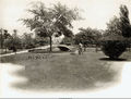
Capitol Park in 1910


.jpg)


References
- White, Marjorie Longenecker, ed. (1980) Downtown Birmingham: Architectural and Historical Walking Tour Guide, second edition. Birmingham: Birmingham Historical Society
- Campbell, Cathryn S. "A History of Central - Capitol - Woodrow Wilson - Linn Park" in Morris, Philip A. and Marjorie Longenecker White, eds. (1989) Designs on Birmingham: A Landscape History of a Southern City and Its Suburbs Birmingham: Birmingham Historical Society
- Fazio, Michael W. (2010) Landscape of Transformations: Architecture and Birmingham, Alabama. Knoxville, Tennessee: University of Tennessee Press ISBN 9781572336872