Gardendale: Difference between revisions
No edit summary |
No edit summary |
||
| Line 75: | Line 75: | ||
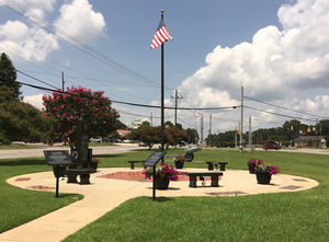
[[Image:Gardendale_Memorial_Park.jpg|right|300px|thumb|Veteran's Memorial Park]] | [[Image:Gardendale_Memorial_Park.jpg|right|300px|thumb|Veteran's Memorial Park]] | ||
* [[Clemons Recreational Complex]] | * [[Clemons Recreational Complex]] | ||
** [[Celebration Park]] | ** [[Celebration Park]] | ||
*** [[Splash Pad (Gardendale)|Splash Pad]] | *** [[Splash Pad (Gardendale)|Splash Pad]] | ||
** [[Disc Golf (Gardendale)|Disc Golf]] | ** [[Disc Golf (Gardendale)|Disc Golf]] | ||
** [[Dog Park (Gardendale)|Dog Park]] | ** [[Dog Park (Gardendale)|Dog Park]] | ||
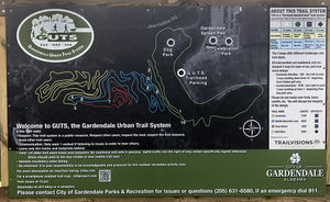
** [[Gardendale Urban Trail System]] | ** [[Gardendale Urban Trail System]] | ||
** [[Soccer Fields (Gardendale)|Soccer Fields]] | ** [[Soccer Fields (Gardendale)|Soccer Fields]] | ||
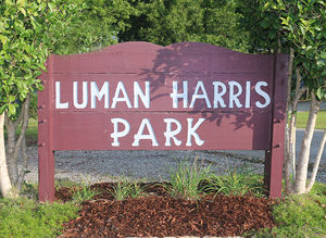
* [[Luman Harris Park]] | * [[Luman Harris Park]] | ||
Revision as of 15:51, 24 April 2017
| City of Gardendale | |

| |
| Incorporated | 1955 |
|---|---|
| Population | 13,729 |
| Mayor | Stan Hogeland |
| School district | Jefferson County Schools |
| Government |
Gardendale City Council |
| Web site | cityofgardendale.com |
| |
| Locate with Google Maps | |
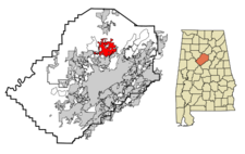
Gardendale is a city of 13,729 located on 22.54 square miles of northern Jefferson County. It was incorporated in 1955.
The first homestead within the present limits was the farm of Otis Dyer, purchased from the United States for 12 1/2 cents per acre in 1825. William H. Parker opened a grist mill in 1873, followed soon by a canning cooperative founded by James Kimmons. Kimmons donated the land on which the first church, Chalybeate Baptist Church, was built in 1876.
The town's first school, called Milner School for John T. Milner who donated lumber for its construction, opened in 1892 on Mount Olive Road.
At the time the settlement was often referred to as Jugtown for a jug and churn pottery nearby. In 1906 schoolteacher Hettie Thomason Cargo succeeded in her campaign to rename the community.
In 1955 Gardendale was incorporated as a municipality with J. I. Pesnell as its first mayor.
Recent development of the city, especially along Fieldstown Road, has been spurred on by the completion of I-65 in 1985.
Geography
U. S. Highway 31 is the north-south artery that defines the center of Gardendale, with recent development occuring westward at interchanges with I-65. Exit 271, 10 miles north of the I-20/59 interchange in Birmingham gives access to Fieldstown Road; Exit 272 to Mount Olive Road.
The town of Morris is six miles north of Gardendale while Fultondale is adjacent to the south. The unincorporated community of Mount Olive lies to the east, portions of which have been annexed by Gardendale. Gardendale is about nine miles north of Birmingham.
Demographics
As of the census of 2010, there were 13,893 people residing in the city's 6,040 housing units. The population density was 616.1/mi² with housing units at an average density of 257.9/mi². The racial makeup of the city was 97% White and 1.5% Black. 0.65% of the population were Hispanic or Latino of any race.
In 2000, there were 4,733 households out of which 28.8% had children under the age of 18 living with them, 61.3% were married couples living together, 9.6% had a female householder with no husband present, and 26.6% were non-families. 24.6% of all households were made up of individuals and 11.7% had someone living alone who was 65 years of age or older. The average household size was 2.42 and the average family size was 2.88.
In the city the population was spread out with 21.5% under the age of 18, 7.4% from 18 to 24, 26.9% from 25 to 44, 25.6% from 45 to 64, and 18.6% who were 65 years of age or older. The median age was 42 years. For every 100 females there were 87.8 males. For every 100 females age 18 and over, there were 83.5 males.
The median income for a household in the city was $45,786, and the median income for a family was $56,929. Males had a median income of $36,714 versus $29,039 for females. The per capita income for the city was $22,673. About 3.5% of families and 5.1% of the population were below the poverty line, including 7.0% of those under age 18 and 7.3% of those age 65 or over.
The Jefferson County Board of Equalization evaluated 4,215 homes in Gardendale and determined that their average market value for 2007 was $164,515, a 5.0% increase since 2006.
Gardendale's Population, 1960-2010
year     pop.    %change

1960 |  4,721 |          |
1970 |  6,537 |  +38.5%  |
1980 |  7,928 |  +21.3%  |
1990 |  9,251 |  +16.7%  |
2000 | 11,626 |  +25.7%  |
2010 | 13,893 |  +19.5%  |
Government
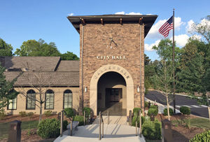
Mayor of Gardendale Stan Hogeland is currently serving his second term in office. Administrative offices are located in the Gardendale City Hall at 925 Main Street. The city operates a civic center, a fire department, police department, a parks and recreation department, a public works department, an inspections department, and a public library.
Gardendale is divided into five districts, each of which elects one representative to the City Council. The current council members are:
- District 1: Allen Jerkins
- District 2: Adam Berendt
- District 3: Alvin Currington
- District 4: Greg Colvert
- District 5: Will Hardman
The council meets twice a month, on the first and third Monday evenings at City Hall.
Gardendale's schools (Gardendale High School, Bragg Middle School, Snow Rogers Elementary School, Gardendale Elementary School and Mount Olive Elementary School) are in the Jefferson County School System.
The North Jefferson Satellite of the Jefferson County Courthouse is located at 651 Main Street, Suite 127 in Gardendale. It opened in 2006, but was closed in 2011 as the county addressed a financial crisis. However, funding was restored in 2017 and the courthouse reopened for business on January 23, 2017.
Community Events
- The annual Christmas Parade is held in December.
- The annual Magnolia Festival takes place in the spring.
- The annual City Softball Tournament is held in the summer.
Parks
- Clemons Recreational Complex
- Luman Harris Park
- Millennium Park
- Mini-Park
- New Castle Park
- Noble Athletic Complex
- Veterans Memorial Park
See also
- Gardendale Arts Council
- Gardendale Chamber of Commerce
- Gardendale City Council
- Gardendale Civic Center
- Gardendale Historical Society
- William Noble Recreation Complex
- Caufield Square
References
- "Gardendale, Alabama" (February 11, 2007) Wikipedia - accessed March 8, 2007
External links
- City of Gardendale official website
- Chamber of Commerce website
- Kenneth Clemons Recreational Complex Facebook page
- Gardendale historical marker at hmdb.org
| Jefferson County | |
|---|---|
| Topics |
Communities | County Commission | Courts | Schools | Sheriff |
| Cities |
Adamsville | Bessemer (seat) | Birmingham (seat) | Brighton | Brookside | Cardiff | Center Point | Clay | Fairfield | Fultondale | Gardendale | Graysville | Homewood | Hoover | Hueytown | Irondale | Kimberly | Leeds | Lipscomb | Maytown | Midfield | Morris | Mountain Brook | Mulga | North Johns | Pinson | Pleasant Grove | Sylvan Springs | Tarrant | Trafford | Trussville | Vestavia Hills | Warrior | West Jefferson |
