20th Street South: Difference between revisions
Jump to navigation
Jump to search
| Line 132: | Line 132: | ||
===[[4th Avenue South]]=== | ===[[4th Avenue South]]=== | ||
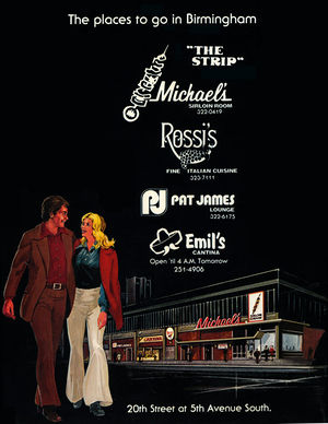
[[File:1977 The Strip ad.jpg|right|thumb|300px|1977 advertisement for "The Strip"]] | |||
:''start of [[UAB]] campus'' | :''start of [[UAB]] campus'' | ||
* West side | * West side | ||
** 400-428: [[UAB Proton Center]] (2019-), former site of the [[Parliament House]] hotel (1964-2008), [[UAB Parking Lot 55]] (2008-2017) | ** 400-428: [[UAB Proton Center]] (2019-), former site of the [[Parliament House]] hotel (1964-2008), [[UAB Parking Lot 55]] (2008-2017) | ||
*** 400-406: [[The Brunswick]] Hotel (1887) | *** 400-406: [[The Brunswick]] Hotel (1887) | ||
**** 400: former location of [[P.K. McMiller]] druggist (1887) | **** 400-402: former location of [[Clyde Lancaster]] refrigerators (1941) | ||
**** 402: former location of [[Young & Gage]] grocers (1887) | ***** 400: former location of [[P.K. McMiller]] druggist (1887) | ||
***** 402: former location of [[Young & Gage]] grocers (1887) | |||
*** 428: former location of [[Central Cafe]] (1928) | *** 404: former location of [[J. L. Morrison & Co.]] dry goods (1887), [[Willis & Randall]] dry goods (1888), [[George Crow]] furniture (1941) | ||
**** 404½: former location of [[Brother Bryan Community Center]] (1941) | |||
*** 406: former location of [[McKee Hardware Co.]] (1941) | |||
*** 408-410: former location of [[Hill's Food Stores]] "Big Store" (before 1914), [[Southern Wholesale Floral Co.]] (1941) | |||
*** 420: former location of [[Atherton Co.]] signs (1941) | |||
*** 422: former location of [[Master's Motor Co.]] sporting goods (1941) | |||
*** 424: former location of [[A. D. Snyder]] cabinet shop (1941) | |||
*** 426: former location of [[Lyman Stribling]] grocery (1941) | |||
*** 428: former location of [[Central Cafe]] (1928-1941) | |||
*** 430: former location of [[Hill's Food Stores]] (1941) | |||
* East side | * East side | ||
** 401-411: [[Bristol Southside]], former location of [[Drennen Motor Company]] (1941-1964), [[Tom Williams Buick]] | ** 401-411: [[Bristol Southside]], former location of [[Drennen Motor Company]] (1941-1964), [[Tom Williams Buick]] | ||
** 417- | ** 417-431: "[[The Strip]]" | ||
** 421: [[Classic 13 Tattoo]], former location of [[Bill's Auto Accessories]] (1924), [[Romeo's Grill]] (1964) | ** 421: [[Classic 13 Tattoo]], former location of [[Bill's Auto Accessories]] (1924), [[Romeo's Grill]] (1941-1964) | ||
*** 423: [[Crescendo Bar & Lounge]], former location of [[Orthopedic Appliance Co.]] (1964), [[Pat James Lounge]] (1977), [[Ona's Music Room]] (1997-2010) | *** 423: [[Crescendo Bar & Lounge]], former location of [[Central Sign Co.]] (1941), [[Orthopedic Appliance Co.]] (1964), [[Pat James Lounge]] (1977), [[Ona's Music Room]] (1997-2010) | ||
*** 425-427: former location of [[ | *** 425-427: former location of [[Rees Brothers]] auto washing & storage (1923), [[Rees Auto Service]] (1941) | ||
**** 425: [[Quality Shoe Repair]], former location of [[Michael's]] offices (1964), [[Emil's Cantina]] (1977) | **** 425: [[Quality Shoe Repair]], former location of [[Michael's]] offices (1964), [[Emil's Cantina]] (1977) | ||
***** 425½: former location of [[McCormick Realty]] office (1964) | ***** 425½: former location of [[McCormick Realty]] office (1964) | ||
*** 427: former location of [[Rossi's]] (1977), [[Xindigo Blue]] | *** 427: former location of [[Rossi's]] (1977), [[Xindigo Blue]] | ||
*** 431: [[Pizza Hut]], former location of | *** 431: [[Pizza Hut]], former location of [[Maxwell Brothers Furniture Co.]] (1941), [[Halwood's Restaurant]] (1962-), [[Michael's|Michael's Sirloin Room]] (1964-1977) | ||
*** 433: [[Syndicate Lounge]]<!--this is the address they use...--> | *** 433: [[Syndicate Lounge]]<!--this is the address they use...--> | ||
===[[5th Avenue South]]=== | ===[[5th Avenue South]]=== | ||
* West side | * West side | ||
Revision as of 12:25, 8 December 2017
20th Street South is a north-south street in midtown and southside Birmingham. 20th Street begins at the southern end of 20th Street North at the Railroad Reservation. From there it first crosses Powell Avenue, and then continues through Southside for sixteen blocks to where it intersects with Richard Arrington Jr Boulevard South.
The street runs through the UAB Medical Center, and from 10th Avenue South to Highland Avenue, it is the main road through Five Points South, a major restaurant and entertainment hub of the city.
Notable Locations (north to south)
For an alphabetical list of locations, see the 20th Street South category.
Railroad Reservation/20th Street underpass
- road continues north as 20th Street North
- West side
- 4: former location of T. N. Ballabanos restaurant (1897)
- 2-8: former location of Crane Co. plumbing supply (1941)
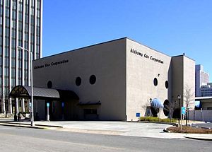
- 12-14: vacant, owned by Alabama Power Company, former location of Associates Sales Agency wholesale toys (1964) and Alabama Business Furnishings
- 12: former location of Wittichen Coal & Transfer Co. (1920), The Starr Co. pianos & refrigerators (1941)
- East side
- 1: former location of Royal Tire Co. filling station (1941), Louisville & Nashville Railroad freight agency and Gulf, Mobile & Ohio Railroad freight office (1964)
- 5: former location of Mathieson Alkali Works/Wood Distributing Co./Jefferson Distributing Co./McCall Brokerage Co. (1941), Supreme Beverage Co./Jefferson Distributing Co./Olin-Mathieson Chemical Co. (1964)
- 9: former location of Southern Railway freight office and Alabama Great Southern Railroad freight office (1941-1964)
Powell Avenue
- West side
- 18-20: former location of San Pedro Wine Co. (1941), A. B. Dick Co. business machines (1964)
- 18: former location of Charles Leno Restaurant (1887)
- 20: Alagasco Building/Alagasco Center for Energy Technology, former location of A.L. Baxter dyer (1887), National Bank of Commerce (1965)
- 22: : former location of Gulf States Sales (1941), Junior League Nearly New Shop (1964)
- 24: former location of The Greenwood Co. real estate/Washington National Insurance Co. (1941), Culberson Dance Studio (1956), Carolyn Cooper Rejuvenating Cosmetics (1964)
- 26: former location of G. De Whiting restaurant (1897), Bates Valve Bag Corp./St Regis Paper Co. (1941)
- 28: former location of Southern States Equipment Corp. (1941), M & F One Stop Record Mart (1964), Studio of Professional Arts (1966)
- 28½: former location of Alabama National Guard Special Forces Headquarters (1964)
- 30-34: former location of Seaboard Air Line Railroad freight office, freight station, passenger station and police (1964)
- 94: former location of Schultz & Maynard Restaurant (1887)
- 96: former location of Robert Darden Restaurant (1887)
- 18-20: former location of San Pedro Wine Co. (1941), A. B. Dick Co. business machines (1964)
- East side
- 15-23: Daniel Building, headquarters for Compass Bank, former location of Milner & Kettig mill, mining & plumbing supply (1870s), Carlisle Electric Appliance Co. (1940-1941),
Moore-Handley appliance department (1964)
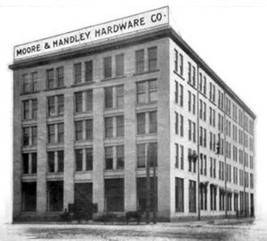
- 25-31: former location of Moore-Handley Hardware Co.
1st Avenue South
- former site of W. A. Mitchell & Co. saloon
- West side:
- 102: former location of Tepetekatz Galivon (1887), Adamson Motor Co. used cars (1941)
- 104: former location of M.H. Burger (1887)
- 106: former location of John W. Apel Grocery (1887), L & N Hotel (1910)
- 110: former location of J.C. Phillips grocer (1887), Aetna Auto Finance Co. (1941)
- 112: former location of New Idea Stove & Hardware Company, Clark & Jones household appliances (1941), Simmons Electric Co. (1964)
- 114: former location of R. Robinson & Son clothier (1887), Shunnarah Trading Co. (1964-1979)
- 116: former location of Julius Berman jewelers (1887), Leonard Lischkoff 2nd hand clothes (1941), ABC Letter Service (1964), Suds & Such Lounge (1970s-1980s), Destin Lounge (1985)
- 118½: former location of P. H. Hill & Co. restaurant (1897)
- 120: former location of H.E. Kline druggist (1887)
- 122: former location of Dusenberry Saloon (1887)
- 124-130: Adamson Ford dealership (1964-)
- 124: former location of S.C. Ferguson grocer (1887), Mill & Mine Supply Co. (1941)
- 130: former location of Nite-N-Gale Grill restaurant (1941)
- East side: Block 121, formerly site for a proposed Shepherd Centre
- 101-131 Station 121 (built as Cityville 121 in 2010)
- 101: Glory Bound Gyro Co., former location of W. H. Holzendorf livery stable (1884), Orkin pest control (1948), Shepherd-Sloss Realty Co. and Sloss Realty Co. (1964)
- 103: former location of Birmingham Plating Works (1941), Birmingham Water Works payment center
- 105: former location of Jim Davis used cars (1941), FedEx Kinko's
- 107: UAB Urgent Care (styled 125) (2015-), former location of Reed Books, former office building housing Barker Insurance Co. and Superior Risks Insurance Services (1964)
- 109: Salon U Midtown / Sprout & Pour (2015-), former location of C. E. Davey Co. machines (1941-1964), Scott's Koneys (1995-2007)
- 113: Momma Goldberg's Deli (2012-)
- 115-131: former location of Express Oil Change (-2009)
- 117: OrangeTheory fitness center (2015-)
- 121-123: former location of White-Blakeslee Garage (1904)
- 121: former location of Spradling Supply Co. auto top manufacturers (1941), Dixie Wholesale Optical Co. (1964)
- 123-127: former location of Flint Refrigeration Co. (1941)
- 125-129: Pies & Pints (2016-)
- 127: former location of Southside Banking Co. (1925)
- 129-131: former location of Rex Service Station (1941)
- 129: former location of Cain's Cafe (1928)
- 101-131 Station 121 (built as Cityville 121 in 2010)
2nd Avenue South
- West side
- 200: Apartment and retail project, former location of Bethea Brothers Grocery (1887)
- 202: former location of C.C. Clayborn grocer (1887)
- 202½: former location of Hood-Wheeler Furniture Co. storage (1941)
- 204: former location of Bains, Duncan & Co. druggists / F. S. Jobson jewelery (1887), Hood-Wheeler Furniture Co. (1941)
- 206: former location of City Shoe Rebuilders (1941)
- 208: former location of Good Service Barber Shop (1923), Samuel Roberts barber (1941)
- 210: former location of Quality Cafe restaurant (1941)
- 214: former location of Birmingham Lunch Room (1928)
- 216: former location of M. Muller fish seller (1888)
- 218: former location of J.C. Goldwire grocer (1887)
- 220: former location of H. S. Perry Barber Shop (1887)
- 222: former location of J.H. Whaley & Co. fruit dealers (1887)
- 230: Publix supermarket (2016-), former location of Brown & Stribling butcher & seafood (1923), L. F. Stribling Fresh Meats, Poultry and Game (1934), Firestone Building Firestone Tires (1943-1964, demolished 2015)
- East side
- 201-231: 20 Midtown (built 2016)
- 201-203: former location of Barlow Service Station (1941)
- 201: former location of Mayfield Cleaners (1964)
- 209: former location of Postal-Telegraph Cable Co. (1941) Industrial Diesel Hydraulics (1964-demolished 2016)
- 209½: former location of Alabama Printing Co. (1941-1964)
- 211: former location of Chicago Pneumatic Tool Co. (1941), Birmingham Appliance Service (1964)
- 213-215: former location of Hammack Motor Co. auto repairs (1939-1941), E. R. Wood Auto Service (1964)
- 217: former location of Grover & Blatzer Machine Co. (1939), Daniel Moody bicycles (1939-1949), City Cycle Shop (1964)
- 219: former location of Luthy Piston Ring Sales (1941)
- 221-223: former location of Mayfield Cleaners main office (1946-1964)
- 221: former location of Magic Cleaners (1941), Magic City Cleaners (1943)
- 223: former location of Thomas F. Healey furniture (1939-1943)
- 225: former location of Robert Harbin drug store (1939)
- 231: former location of Robert Harbin Drugs (1941) Likis Brothers Cafe (1964),
- 201-203: former location of Barlow Service Station (1941)
- 201-231: 20 Midtown (built 2016)
3rd Avenue South
- West side
- 300-308: 20 Midtown (built 2015)
- 300: former location of Piggly-Wiggly grocery store (1939), Drennen Motor Co. used cars (1941-1964), Adamson Ford auto lot
- 300-302: Chipotle (December 2015-)
- 304: former location of Moore's Auto Top Co. & Atherton Signn Co. (1923)
- 308: Starbucks Coffee (August 2015-)
- 312-314: former location of Burks Furnace Exchange (1941)
- 312: B.O.S.S. Ultra Bar & Lounge, former location of U.S. Post Office Station No. 8 (1964), Coalyard restaurant (1970-), Amigo's restaurant (1980s), Cafe 312 (1996), Club 312
- 314: former location of Harbin Pharmacy (1964)
- 316: former location of Albert Tebshrany dry goods (1941), Rockefeller's night club, Joe Namath's Restaurant
- 318: former location of P. J. Carroll, watchmaker (1923), Luther Adams 2nd hand clothes (1941)
- 320: former location of Bright Star Cafe (1928-1934), B. E. Erben Grocer (1934), New Deal Cafe (1937), Rex Grill (1941)
- 322: former location of H. E. Klein drug store (1888), Klein Bros. chemists and druggists (1904), Horace Goodman Druggist (1934-1841)
- 324: former location of Sol's Hot Dogs
- 300-308: 20 Midtown (built 2015)
- East side
- 301-307: Liberty National Building (built 1925 as the Pioneer Building), former headquarters for Liberty National Life Insurance Company, Southside Bank, and U. S. Bureau of Investigation's Birmingham field office (1925-)
- 301: former location of Vulcan Radiator Co. (1923)
- 303: former location of Southern Bearing Company (1923), Western Union telegraph office (1941)
- 309-313: former location of Alabama Tin Shop (1941)
- 309: former location of Masters Tire Co. (1923)
- 315-317: former location of Howard Odorless Cleaners / R. E. Moffatt plumbing & heating (1941)
- 315: former office location of Earnest McMeans manufacturer's agent (1964)
- 315½: former location of Bethune Electric Co. (1941)
- 321-331: former location of Drennen Motor Company (1941-1964), Tom Williams Cadillac
- 325-331: SpringHill Suites (2011-), (built as Hyatt Place Hotel in 2009)
- 315: former office location of Earnest McMeans manufacturer's agent (1964)
- 301-307: Liberty National Building (built 1925 as the Pioneer Building), former headquarters for Liberty National Life Insurance Company, Southside Bank, and U. S. Bureau of Investigation's Birmingham field office (1925-)
4th Avenue South
- start of UAB campus
- West side
- 400-428: UAB Proton Center (2019-), former site of the Parliament House hotel (1964-2008), UAB Parking Lot 55 (2008-2017)
- 400-406: The Brunswick Hotel (1887)
- 400-402: former location of Clyde Lancaster refrigerators (1941)
- 400: former location of P.K. McMiller druggist (1887)
- 402: former location of Young & Gage grocers (1887)
- 400-402: former location of Clyde Lancaster refrigerators (1941)
- 404: former location of J. L. Morrison & Co. dry goods (1887), Willis & Randall dry goods (1888), George Crow furniture (1941)
- 404½: former location of Brother Bryan Community Center (1941)
- 406: former location of McKee Hardware Co. (1941)
- 408-410: former location of Hill's Food Stores "Big Store" (before 1914), Southern Wholesale Floral Co. (1941)
- 420: former location of Atherton Co. signs (1941)
- 422: former location of Master's Motor Co. sporting goods (1941)
- 424: former location of A. D. Snyder cabinet shop (1941)
- 426: former location of Lyman Stribling grocery (1941)
- 428: former location of Central Cafe (1928-1941)
- 430: former location of Hill's Food Stores (1941)
- 400-406: The Brunswick Hotel (1887)
- 400-428: UAB Proton Center (2019-), former site of the Parliament House hotel (1964-2008), UAB Parking Lot 55 (2008-2017)
- East side
- 401-411: Bristol Southside, former location of Drennen Motor Company (1941-1964), Tom Williams Buick
- 417-431: "The Strip"
- 421: Classic 13 Tattoo, former location of Bill's Auto Accessories (1924), Romeo's Grill (1941-1964)
- 423: Crescendo Bar & Lounge, former location of Central Sign Co. (1941), Orthopedic Appliance Co. (1964), Pat James Lounge (1977), Ona's Music Room (1997-2010)
- 425-427: former location of Rees Brothers auto washing & storage (1923), Rees Auto Service (1941)
- 425: Quality Shoe Repair, former location of Michael's offices (1964), Emil's Cantina (1977)
- 425½: former location of McCormick Realty office (1964)
- 425: Quality Shoe Repair, former location of Michael's offices (1964), Emil's Cantina (1977)
- 427: former location of Rossi's (1977), Xindigo Blue
- 431: Pizza Hut, former location of Maxwell Brothers Furniture Co. (1941), Halwood's Restaurant (1962-), Michael's Sirloin Room (1964-1977)
- 433: Syndicate Lounge
5th Avenue South
- West side
- 500-512: former location of B. F. Goodrich Store tires (1964)
- 502: Alabama Organ Center
- 506: former location of New-Life Battery Co. (1938)
- 510: Faculty Office Tower
- 514: former location of Teriyaki House (1996)
- 516: UAB School of Health Professions Research and Clinics (located on the ground floor of the 6th Avenue Deck), former location of Frances Gibbs Beauty Salon (1964), former location of Ambulatory Dialysis Center (1976)
- 518: former location of LeJoy Uniforms (1964)
- 520: former location of Fadool & Son groceries (1925), Al's Grill (1964)
- 520½: former location of C. Reed Traylor, dentist office (1964)
- 522: former location of Quan You Laundry and Dry Cleaning plant #2 (c. 1938), Custom Laundry & Cleaners (1964)
- 526: UAB Lung Health Center (located on the ground floor of the 6th Avenue Deck), former location of T.G. Morgan grocer (1887)
- 524-528: former location of Bargain Center variety store (1964)
- 530: former location of James' Cafe (1964)
- 532: former location of Andres's Confectionary (1964)
- East side
- 501-531: Kirklin Clinic, former site of Paul Hayne School
- 511: former location of Birmingham Federal Savings & Loan, Liberty Mutual Insurance Co., Lehmann, Ullman & Barclay accountants (1964)
- 515-517: former location of New Yorker Beverage Co. (1935-1939)
- 519-521: former location of Birmingham Limb & Brace (1964)
- 519: former location of S. J. McAlister supplies (1923)
- 521: former location of Ellis Barbecue
6th Avenue South
- Former location of Street Car Diner
- West side
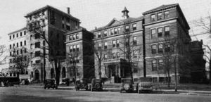
- 600-618: Hillman Hospital (1903), William Elias B. Davis statue
- 620: former location of Birmingham Medical College, University of Alabama Medical College Library
- East side (Block 188)
- 601-633: Kirklin Clinic Parking Lot
- 601: former location of Southside Baptist Church (-1906)
- 609: former location of General Finance Corp. of Birmingham (1964), Andrew's Sandwich Shop (1978)
- 611: former location of Jackson Tire Co. (1923), Raiford's Shoes orthopedic shoe store (1964)
- 613: former location of Hogie's Hotdogs
- 615: former location of Dobb's House diner (1964), Doubletime Deli (1985-)
- 623: former location of General Acceptance Corp. (1964)
- 627: former location of Durr Surgical Supply (1964)
- 629: former location of Street Car Diner No. 1, Post House Snack Bar (1964)
- 633: former location of Ted's Auto Clinic (1964)
- 601-633: Kirklin Clinic Parking Lot
7th Avenue South
- West side
- 700: former location of Madison Drug (1950)
- 702: former location of Service Paint & Wall Paper (1950)
- 704: former location of McCormick & Company (1950) real estate
- 708: former location of John Gonder (1950) used cars
- 705-720: Hugh Kaul Human Genetics Building (built 2001)
- 720: former location of University of Alabama Extension Center, renamed Tidwell Hall in 1956, Birmingham Area Educational Television Association (1964)
- 728: McCallum Basic Health Sciences Building, former location of Jefferson County Public Health Building
- East side
- 701: UAB administration building, formerly Central Bank building (1967), formerly James A McFarland used cars (1950)
- 715: former location of Carpet Golf, Henley's Golf Course, Medical Center Putt-Putt (1940s-1963)
- 719: former location of All Seasons Travel, former location of Bodine, Bryson & Rolling, Inc., former location of Hawkins-Israel Company, Inc. (1950) interior decorators
- 721: former location of Royal Motor Company (1950) used cars
- 725-731: Town House (built 1953, demolished 2018)
- 725: Sitar Indian Cuisine, former location of City Federal Savings & Loan (1981), Town House Beauty Salon (1964)
- 727-729: Sitar Indian Cuisine, former location of Tracy's Cafeteria (1983-2008), Frances' Flowers & Gifts (1964)
- 731: Sitar Indian restaurant, former location of Scotty's Discount Drugs (1981), Tubb Pharmacy (1964), former location of Erskine A Caldwell (1950) used cars
University Boulevard (formerly 8th Avenue South)
- West side
- 800-810 Doubletree Hotel Birmingham, formerly Kahler Plaza Hotel, Radisson Hotel, former site of University of Alabama Girl's Dormitory
- 800: former location of J Gatsby's restaurant
- 808: J. Reiss Custom Clothier, inside hotel
- 812-814: former location of Chi Tau Chapter of Psi Omega (1964)
- 816-822: former location of University of Alabama Medical School Dormitory (1964)
- 822-824: former location of The Dental Dormitory (1964)
- 826-828: former location of Sigma Nu fraternity house (1964)
- 800-810 Doubletree Hotel Birmingham, formerly Kahler Plaza Hotel, Radisson Hotel, former site of University of Alabama Girl's Dormitory
- East side
- 801-805: former location of Grayson's Spinning Wheel
- 801: Wings Around the Clock, former location of New York Bagel Cafe (1996-2006), Zoes, Starbucks Coffee, Andrew's Sandwich Shop (- 1993)
- 803: Subway
- 805: former location of Chapman Radio & Television (1950), former location of Chapman Record Bar (1950), former location of Radio Sales & Service (1950)
- 807: former location of Baptist Building, offices of Birmingham Baptist Association, Birmingham Baptist Women's Missionary Union, The Alabama Baptist newspaper, Albie Smith architect, Weir & Shannon attorneys, and National Electrical Contractors Association (1964), Dewberry Engraving (1950)
- 811: Medical Alumni Building, Rose Law Firm, formerly Birmingham Medical & Surgical Clinic, offices of Jefferson Health Foundation, Jefferson Medical Group and other physicians, office of R. C. Green, later Brown-Service Funeral Home and Ridout's Funeral Home
- 821: Southside Residence Inn, former site of James Van Hoose residence, Brown-Service Funeral Company funeral home (1935), Birmingham Travelodge (1964), later Passport Inn and Royal Inn
- 801-805: former location of Grayson's Spinning Wheel
8th Court South
9th Avenue South
- West side
- 900: former location of Lige Loy Funeral Home
- 908: UAB Community Care Building, 1917 Clinic
- 916: former location of Birmingham Institute of Physical Medicine rehabilitation clinic (1964)
- 920: former residence and offices of The Hogan Clinic (1964)
- 930: UAB Community Health Services Building, UAB Family Medicine/Civitan-Sparks Clinic, former location of residence, offices of Blue Cross Blue Shield of Alabama (1964)
- 936: former location of Toddle House restaurant
- 940: Makarios, former location of Gulf 20th Street Service Station (1964), Kentucky Fried Chicken, Chinese Express, China Way Restaurant
- East side
- 929: Regions Bank parking lot
- 937-943: Exchange Security Bank of Birmingham building (built 1947)
- 937: former location of Five Points Shoe Hospital (1947-1949)
- 941: Regions Bank branch, former location of Exchange Security Bank of Birmingham (1947-1971)
- 943: former location of Mary Ball Candies (1947-1949)
10th Avenue South intersection
- Five Points South begins'
- West side
- 1000: Five Points Paint & Hardware (1971-), former location of Parker Grocery Co. (1946)
- 1004: former location of Pandora Beauty Shop (1964)
- 1006: former location of Pandora Beauty Shop (1934)
- 1006-1012: Five Points Social (2017-), former location of Woolworth's, Five Points Market (1941), Bailey Brothers Music
- 1016: Homewood Suites Five Points South, former location of Piggly Wiggly (1934), Hill Grocery, Five Points South Music Hall (1994), The Arena, Banana Joe's, and Five Points Music Hall
- 1020: New China Town Restaurant (2003-), former location of Manufacturers' Outlet Stores (1964)
- 1022: Wicked Ways Tattoos, former location of Yogurt Etc. (1986)
- 1024: former location of Lane-Rexall Drugs, A & P supermarket, South Place bar, Arena Sports Club, Base Camp Lounge, and Infinity
- 1026: Noni's restaurant, former location of Five Points Barber Shop (1941-1971), Lola’s Kitchen, and Hogie's Hot Dogs & Deli
- 1028-1030: Cloud Nine, former location of Piggly Wiggly (1921), and Bohemian Rhapsody
- 1028: former location of Slipper Shop (1980s)
- 1032: Birmingham Apothecary, former location of Highland Pharmacy (1900), and P & S Apothecary (1964)
- 1050: Studio Arts Building, Waffle House, former location of Johnny Rockets, Scheaffer Eye Center
- East side
- 1001: The Break, former location of the Emily Shop
- 1005-1035: Pickwick Plaza
- 1005: Sleek Sports Bar (October 2017-), former location of Jack Moore Optical (1964), The Outrigger, Rube Burrows Food and Spirits (1980s-1996), Nirus, Surin on 20th, LaJaras (1999), Halfshells (2000-2006), World of Beer (2012-November 30, 2016), Magic City Brew (November 30-December 31, 2016)
- 1007: former location of Scott's Apothecary (1964)
- 1009-1011: former location of Allright Auto Park parking lot (1964)
- 1011: Exclusive Apparel (2015-), former location of Five Points Radio Service (1949), Texas Taco & Chili Co., Buffalo Cafe, Sabor Tropical (2001-2014)
- 1015: former location of Marie's Coffee Shop (1964), Five Points Restaurant & Lounge (1971)
- 1017: T-Bones (2014-), former location of Hall's Men's Shop (1964), Subway, Purple Onion, Camp Taco (2009-2011)
- 1019: former location of Medical Arts Optical (1964)
- 1021: Phone Clinic, former location of Birmingham Apothecary (1964)
- 1023: Medical Arts Building, Hotel Highland (formerly Pickwick Hotel)
- 1025: Pho Pho (2015-), former location of Sakura, Sekisui
- 1027-1035: former location of Five Points Drug Co. (1910s)
- 1027: former location of Five Points Shoe Hospital (1934-1941)
- 1031-1035: Black Market Bar & Grill (2015-), former location of The Grill/The Mill (1990-2000s, 2010), Five Points Grill (2000s), No Way José Café (2000s-2010), Metroprime Steakhouse (2011-2015)
- 1031: former location of Mayberger's Variety Shop (1930s-1964)
- 1033: former location of Almost Famous (1980s)
- Brother Bryan statue
Magnolia Avenue
- 1045: Storyteller fountain, Highlands United Methodist Church, former site of Phillip Alosi’s Palace Market
11th Avenue South
- West side
- 1100-1102: Munger Building
- Original Pancake House, former location of Southpoint Restaurant (1980s), Edgar's Grill (1989)
- 3000 Bar, former location of Planet Smoothie, High Spirits of Five Points
- 1108: The Red Zone sport bar, former location of Prudential Insurance, The Gap, Quincy toys and Fire and Ice Improvisational Grill
- 1110: under construction in 1964
- 1116: UPS Store, former location of A. Kimbell Business Machines (1964), Subzone
- 1124: Terrace Court Building
- 1124: former location of Alcoholics Anonymous (1964)
- 1128: Dave's Pub, former home of Stream of Consciousness Koffiehuis
- 1130: former location of Birmingham Frame & Supply (1964)
- 1100-1102: Munger Building
- East side
- 1101-1105: Spanish Stores
- 1101: Metroprime Steakhouse, former location of Exchange Security Bank of Birmingham, Ionolite research, Gorin's, Joe Muggs Newssstand, The Grape, La Mesa
- 1105: Saloon, former location of Lifskitz Delicatessen, World Winds boutique (1997), Soca Clothing
- 1107: former location of Bun N'Bun restaurant (1964)
- 1195: Chick-fil-A, former location of Shop-A-Snak Food Mart and Connie's Famous Foods, former proposed location for Renaissance Plaza, and former location of Ruby Tuesday
- 1101-1105: Spanish Stores
12th Avenue South/Highland Avenue
- West side
- 1200: Mellow Mushroom, former location of Johnston & Raburn accountants (1964)
- 1204: former location of Alpha Portland Cement (1964)
- 1204a: former location of Municipal Service Co. bookkeeping service (1964)
- 1206: former location of Kaiser Refractories chemical division (1964)
- 1208: former location of Lehigh Portland Cement (1964)
- 1210: 5 Point Public House (2015-), former location of the Twelve Ten Building, offices of Life Insurance Company of Virginia and Security Life Insurance Company of America (1964), Twentysix restaurant (2006-2015)
- 1214: former location of the Portland Cement Association (1964)
- 1218: Ocean, former location of Electronics Computer Programming Institute, Herzing Institute
- 1224: former location of the Pure Oil Co.
- East side
- 1201: Shepherd-Sloss Building, former site of the rooftop Barber's clock
- Crush, former location of Uranus, Bell Bottoms, Louie Louie and Cadillac Cafe
- 1207: Pop's Neighborhood Grill, former location of Mancha's, Pyramids, Curry in a Hurry, and Kohinoor
- 1225: Ranelli's Deli, former location of Five Points Standard Station (1964)
- 1201: Shepherd-Sloss Building, former site of the rooftop Barber's clock
13th Avenue South
- West side
- 1300: Dian Apartments
- 1312: Haskins Williams residence (built c. 1901), 5 Points Brewing, former location of Black & White offices
- 1318-1328: Cobb Lane Apartments
- 1318: former location of Scottish Town Piper (1997), Mad Doctor Game Shop
- 1330: former location of Sparks Tourist Home (1964)
- East side
- 1301: Newton Manor
14th Avenue South
- West side
- 1400: Legacy Federal Credit Union headquarters, former location of A & P Supermarket (1964)
- East side
- 1401: former location of American Liberty Insurance Group, U.S. Department of Labor offices (1964)
15th Avenue South
- West side
- 1500: Sue Ward residence (1964)
- 1512: former location of the Avon Motel (1964)
- East side
- 1501: Zydeco, formerly the "City Club" for the Phoenix Club
- 1505: apartments
16th Avenue South
- 1600: Birmingham Health Care clinic, formerly included Birmingham Financial Federal Credit Union
| U. S. Highway 31 in Birmingham | ||
|---|---|---|
| North side | South side | |
| Current route | Carraway Blvd · Elton B. Stephens Expressway | Elton B. Stephens Expressway |
| Previous routes | 8th Avenue N · 24th Street N | 24th Street S · 7th Avenue S · 20th Street S · 21st Street S |
External links
- Photographs of 20th Street South from the Magic City Flickr Group
