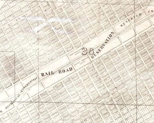
Birmingham city center street grid
The Birmingham city center street grid refers to the layout of the numbered streets (running north-south) and avenues (running east-west) in the Birmingham city center. The original layout of the blocks comprising Birmingham's earliest development was drafted for the Elyton Land Company by William Barker. These Birmingham blocks comprise the original subdivision of the 1,113-acre Elyton Land Company parcel.
The grid pattern is aligned to the route of the Northeast & Southwest Railroad. Its crossing with the South & North Alabama Railroad had determined the location of the new city, and the latter railroad route was made to parallel the earlier one for several blocks, which became the city's "Railroad Reservation". The grid, therefore, was not aligned to the "Jeffersonian" grid of the Public Land Survey, giving the edges of the city's original parcel a zig-zag shape as it was acquired from earlier land owners. Geographical features, such as the steep slopes of Red Mountain, also influenced the grid's extent.
The main portion, bounded by 12th Avenue North to the north, 32nd Street to the east, University Boulevard (8th Avenue South) to the south, and Interstate 65 (between 10th and 11th Streets) to the west, remains largely intact, except for a series of vacated rights-of-way creating "superblocks" within the UAB campus.
Layout
The designating division of the city center is roads north of the Railroad Reservation and those south of it. However, the railroad follows a path through the middle of Jones Valley, which is closer to ENE-WSW than east-west. As a result, the street grid is actually rotated approximately 29-30° west of due north to match the angle of the railroad tracks. This means that the north-south streets run closer to NNW-SSE.
Where the grid has been disrupted or become irregular and an extra north-south street has been inserted, it is typically referred to as a "place", although sometimes "way" is also used. Likewise, where an extra east-west avenue has been inserted, it is typically referred to as a "court", although sometimes "lane" or "terrace" is used. Starting in Woodlawn, where the railroad turns east, and continuing into the East Lake community, Division Avenue takes the place of the railroad tracks as the north-south dividing line.
Rather than being numbered, the two avenues closest to the Railroad Reservation were named for two of Birmingham's founders: Morris Avenue (for Josiah Morris) to the north and Powell Avenue (for James Powell) to the south. The rest of the avenues are numbered, beginning with 1st Avenue North, the next avenue north of Morris, and 1st Avenue South, the next avenue south of Powell. Originally the southern avenues were lettered, starting with Avenue A (now 1st Avenue South). The transition to numbers began in the 1910s to help reduce confusion with the lettered avenues in Ensley, which had been annexed into Birmingham in 1910. Alleyways divide blocks parallel to the avenues and are numbered according to the lower of the adjacent avenues.
The east-west division is based on Center Street, originally Broad Street in the center of Elyton, now in the Smithfield community, almost two miles west of Birmingham's city center. 20th Streets North and South act as the central north-south thoroughfare through the city center. West of Center Street, both streets and avenues are designated as "west" if they are north of Valley Creek, while roads south of the creek are named "southwest".
History
After the Greater Birmingham annexation in 1910, many roads in the formerly independent municipalities were renamed to match the central numbered street grid. While often connected to it, these roads are not always at the same angle as the central grid.
In 1973, 3rd, 4th, 5th, and 6th Avenues North, 3rd and 4th Avenues South, and 17th and 18th Streets North were converted from two-way to one-way traffic by the Alabama Department of Transportation under its TOPICS (Traffic Operations Program to Increase Capacity and Safety) program.
Over the years, some numbered roads have been renamed to honor individuals or institutions, typically with a "boulevard" designation regardless of whether they are oriented east-west or north-south. These include:
- Carraway Boulevard, formerly 26th Street North
- University Boulevard, formerly 8th Avenue South
- Richard Arrington, Jr Boulevard (designated 1999), formerly 18th Street South, 21st Street South, 21st Street North and 10th Avenue North
- Reverend Abraham Woods Jr Boulevard (designated 2008), formerly 8th Avenue North
Notable roads
North side
South side
References
- Fazio, Michael W. (2010) Landscape of Transformations: Architecture and Birmingham, Alabama. Knoxville, Tennessee: University of Tennessee Press ISBN 9781572336872
- USGS Birmingham North topographic map, 1997
