20th Street South: Difference between revisions
Jump to navigation
Jump to search
No edit summary |
|||
| Line 1: | Line 1: | ||
'''20th Street South''' is a [[north-south street]] in midtown and southside [[Birmingham]]. 20th Street begins at the southern end of [[20th Street North]] at the [[Railroad Reservation]]. From there it first crosses [[Powell Avenue]], and then continues for sixteen blocks to where it intersects with [[Richard Arrington Jr Boulevard South]]. | '''20th Street South''' is a [[north-south street]] in midtown and southside [[Birmingham]]. 20th Street begins at the southern end of [[20th Street North]] at the [[Railroad Reservation]]. From there it first crosses [[Powell Avenue]], and then continues through [[Southside]] for sixteen blocks to where it intersects with [[Richard Arrington Jr Boulevard South]]. | ||
The street runs through the [[UAB]] [[Medical Center]], and from [[10th Avenue South]] to [[Highland Avenue]], it is the main road through [[Five Points South]], a major restaurant and entertainment hub of the city. | |||
==Notable Locations (north to south)== | ==Notable Locations (north to south)== | ||
| Line 146: | Line 148: | ||
*** 929: [[Regions Bank]] parking lot | *** 929: [[Regions Bank]] parking lot | ||
*** 941: [[Regions Bank]] branch, former location of [[Exchange Security Bank of Birmingham]] (1964) | *** 941: [[Regions Bank]] branch, former location of [[Exchange Security Bank of Birmingham]] (1964) | ||
* [[10th Avenue South]] intersection (begin [[Five Points South]]) | * [[10th Avenue South]] intersection (begin [[Five Points South]] proper) | ||
**[[ | ** West side | ||
*** | *** 1000: [[Five Points Hardware]] | ||
*** | *** 1004: former location of [[Pandora Beauty Shop]] (1964) | ||
*** | *** 1006-1012: [[Bailey Brothers Music]], former location of [[Woolworth's]] | ||
*** | *** 1016: [[Five Points Music Hall]], former location of [[Hill Food Stores|Hill Grocery]], [[Banana Joe's]], [[Five Points South Music Hall]] and [[The Arena]] | ||
*** | *** 1020: former location of [[Manufacturers' Outlet Stores]] (1964) | ||
*** | *** 1024: [[Infinity]], former location of [[Lane-Rexall Drugs]], [[A & P]] supermarket, [[Piggly Wiggly]] and [[Base Camp Lounge]] | ||
** | *** 1026: [[Hogie's Hot Dogs & Deli]], former location of [[Five Points Barber Shop]] | ||
** | *** 1030: [[Cloud Nine]], former location of [[Bohemian Rhapsody]] | ||
** | *** 1032: former location of [[P & S Apothecary]] (1964) | ||
** | *** 1050: [[Studio Arts Building]], [[Waffle House]], former location of [[Johnny Rockets]], [[Scheaffer Eye Center]] | ||
** | **** 1050 2nd floor: [[Skky]] (former location of [[Studio]], [[Eleven20]], [[Bacchus]] night clubs | ||
** | ** East side | ||
** | *** 1001-1035: [[Pickwick Plaza]] | ||
** [[Brother Bryan statue]] | **** 1001: [[The Break]], former location of the [[Emily Shop]] | ||
**** 1005: former location of [[Jack Moore Optical]] (1964), [[Rube Burrows]], [[Nirus]], [[LaJaras]], [[Halfshells]] | |||
**** 1007: former location of [[Scott's Apothecary]] (1964) | |||
**** 1009-1011: former location of [[Allright Auto Park]] parking lot (1964) | |||
**** 1011: [[Sabor Tropical]] (former location of [[Texas Taco & Chili Co.]]) | |||
**** 1015: former location of [[Marie's Coffee Shop]] (1964) | |||
**** 1017: [[T-Bones]], former location of [[Hall's Men's Shop]] (1964), Subway, [[Purple Onion]], and [[Camp Taco]] | |||
**** 1019: former location of [[Medical Arts Optical]] (1964) | |||
**** 1021: former location of [[Birmingham Apothecary]] (1964) | |||
**** 1023: [[Medical Arts Building]], [[Hotel Highland]] (formerly [[Hotel Highland|Pickwick Hotel]]) | |||
**** 1031: former location of [[Mayberger's Variety Shop]] (1964) | |||
**** 1035: [[Metroprime Steakhouse]], former location of [[The Mill]], [[The Mill|Five Points Grill]] and [[The Mill|No Way José Café]] | |||
*** [[Brother Bryan statue]] | |||
* [[Magnolia Avenue]] intersection ([[Five Points South]]) | * [[Magnolia Avenue]] intersection ([[Five Points South]]) | ||
** 1045: [[Storyteller fountain]], [[Highlands United Methodist Church]] (former site of [[Phillip Alosi’s Palace Market]]) | ** 1045: [[Storyteller fountain]], [[Highlands United Methodist Church]] (former site of [[Phillip Alosi’s Palace Market]]) | ||
Revision as of 21:57, 14 January 2015
20th Street South is a north-south street in midtown and southside Birmingham. 20th Street begins at the southern end of 20th Street North at the Railroad Reservation. From there it first crosses Powell Avenue, and then continues through Southside for sixteen blocks to where it intersects with Richard Arrington Jr Boulevard South.
The street runs through the UAB Medical Center, and from 10th Avenue South to Highland Avenue, it is the main road through Five Points South, a major restaurant and entertainment hub of the city.
Notable Locations (north to south)
For an alphabetical list of locations, see the 20th Street South category.
- road continues as 20th Street North through 20th Street underpass below the Railroad Reservation
- 1: former location of Louisville & Nashville Railroad freight agency and Gulf, Mobile & Ohio Railroad freight office (1964)
- 5: former location of Supreme Beverage Co., Jefferson Distributing Co., and Olin-Mathieson Chemical Co. (1964)
- 9: former location of Southern Railway freight office and Alabama Great Southern Railroad freight office (1964)
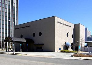
- 12-14: vacant, owned by Alabama Power Company, former location of Associates Sales Agency wholesale toys (1964) and Alabama Business Furnishings
- Powell Avenue intersection
- 15-23: Daniel Building, headquarters for Compass Bank, former location of Moore-Handley appliance department (1964)
- 18-20: former location of A. B. Dick Co. business machines (1964)
- 20: Alagasco Building/Alagasco Center for Energy Technology, formerly National Bank of Commerce (1965)
- 22: former location of Junior League Nearly New Shop (1964)
- 24: former location of Carolyn Cooper Rejuvenating Cosmetics (1964)
- 27: former location of Moore-Handley
- 28: former location of M & F One Stop Record Mart (1964)
- 28½: former location of Alabama National Guard Special Forces Headquarters (1964)
- 30: former location of Seaboard Air Line Railroad freight office, freight station, passenger station and police (1964)
- 1st Avenue South intersection
- former site of W. A. Mitchell & Co. saloon
- West side:
- 112: former location of New Idea Stove & Hardware Company, Simmons Electric Co. (1964)
- 114: former location of Shunnarah Trading Co. (1964)
- 116: former location of ABC Letter Service (1964)
- 124-130: former location of Adamson Ford car lot (1964)
- East side: Block 121, formerly site for a proposed Shepherd Centre
- 101-131 Cityville 121
- 101: Glory Bound Gyro Co., former location of Shepherd-Sloss Realty Co. and Sloss Realty Co. (1964)
- 103: former location of Birmingham Water Works payment center
- 105: former location of FedEx Kinko's
- 107: former location of Reed Books, former office building housing Barker Insurance Co. and Superior Risks Insurance Services (1964)
- 109: former location of C. E. Davey Co. machines (1964), Scott's Koneys (1995-2007)
- 113: Momma Goldberg's Deli (2012-present)
- 115-131: former location of Express Oil Change
- 121: former location of Dixie Wholesale Optical Co. (1964)
- 2nd Avenue South intersection
- West side
- 200: Apartment and retail project.
- 230: former location of Firestone Tires (1964)
- East side
- 201: former location of Mayfield Cleaners (1964)
- 209: former location of Indus Hydraulics (1964)
- 209½: former location of Alabama Printing Co. (1964)
- 211: former location of Birmingham Appliance Service (1964)
- 213-215: former location of E. R. Wood Auto Service (1964)
- 217: former location of City Cycle Shop (1964)
- 219-223: former location of Mayfield Cleaners main office (1964)
- 231: former location of Likis Brothers Cafe (1964)
- West side
- 3rd Avenue South intersection
- East side
- 300: former location of Drennen Motor Co. used cars (1964)
- 312: B.O.S.S. Utra Bar & Lounge, former location of U.S. Post Office Station No. 8 (1964), Coalyard restaurant (1970-), Club 312
- 314: former location of Harbin Pharmacy (1964)
- 316: former location of Joe Namath's Restaurant
- 324: former location of Sol's Hot Dogs
- West side
- 301: Liberty National Building (originally the Pioneer Building), former headquarters for Liberty National Life Insurance Company, Southside Bank, and U. S. Bureau of Investigation's Birmingham field office (1925-)
- 315: former office location of Earnest McMeans manufacturer's agent (1964)
- 325-331: Hyatt Place Hotel, former location of Drennen Motor Co. (1964), Tom Williams Cadillac
- East side
- 4th Avenue South intersection, start of UAB campus
- East side
- 400: former site of the Parliament House hotel
- West side
- 401-411: Bristol Southside, former location of Drennen Motor Co. (1964), Tom Williams Buick
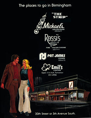
- 417-31: "The Strip"
- 421: former location of Romeo's Grill (1964)
- 423: former location of Orthopedic Appliance Co. (1964), Pat James Lounge (1977), Ona's Music Room (1997-2010)
- 425: former location of Michael's offices (1964), Emil's Cantina (1977)
- 425½: former location of McCormick Realty office (1964)
- 427: former location of Rossi's (1977), Xindigo Blue
- 431: Pizza Hut, former location of Michael's Sirloin Room (1964-77), Halwood's
- East side
- 5th Avenue South intersection
- East side
- 500-512: former location of B. F. Goodrich Store tires (1964)
- 516: former location of Frances Gibbs Beauty Salon (1964)
- 518: former location of LeJoy Uniforms (1964)
- 520: former location of Al's Grill (1964)
- 520½: former location of C. Reed Traylor, dentist office (1964)
- 522: former location of Quan You Laundry and Dry Cleaning plant #2 (c. 1938), Custom Laundry & Cleaners (1964)
- 524-528: former location of Bargain Center variety store (1964)
- 530: former location of James' Cafe (1964)
- 532: former location of Andres's Confectionary (1964)
- West side
- 501-531: Kirklin Clinic, former site of Paul Hayne School
- 511: former location of Birmingham Federal Savings & Loan, Liberty Mutual Insurance Co., Lehmann, Ullman & Barclay accountants (1964)
- 519-521: former location of Birmingham Limb & Brace (1964)
- 521: former site of Ellis Barbecue
- East side
- 6th Avenue South intersection
- Former location of Street Car Diner
- East side
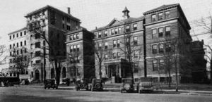
- 600-618: Hillman Hospital (1903), William Elias B. Davis statue
- 620: former location of Birmingham Medical College, University of Alabama Medical College Library
- West side
- 601-633: Kirklin Clinic Parking Lot
- 609: former location of General Finance Corp. of Birmingham (1964)
- 611: former location of Raiford's Shoes orthopedic shoe store (1964)
- 613: former location of Hogie's Hotdogs
- 615: former location of Dobb's House diner (1964)
- 623: former location of General Acceptance Corp. (1964)
- 627: former location of Durr Surgical Supply (1964)
- 629: former location of Street Car Diner No. 1, Post House Snack Bar (1964)
- 633: former location of Ted's Auto Clinic (1964)
- 601-633: Kirklin Clinic Parking Lot
- 7th Avenue South intersection
- East side
- 720: former location of University of Alabama Birmingham Center, Birmingham Area Educational Television Association (1964)
- 728: McCallum Basic Health Sciences Building, former location of Jefferson County Public Health Building
- West side
- 701: UAB administration building, formerly Central Bank building (1967)
- 719: former location of Bodine, Bryson & Rolling, Inc.
- 725-731: Town House
- 725: former location of Town House Beauty Salon (1964)
- 727-729: former location of Frances' Flowers & Gifts (1964)
- 729: Sitar Indian Cuisine, former location of Tracy's Cafeteria
- 731: former location of Tubb Pharmacy (1964)
- East side
- University Boulevard intersection (formerly 8th Avenue South)
- East side
- 800-810 Doubletree Hotel Birmingham, formerly Kahler Plaza Hotel, [[Radisson Hotel, former site of University of Alabama Girl's Dormitory
- 800: former location of J Gatsby's restaurant
- 808: J. Reiss Custom Clothier, inside hotel
- 812-814: former location of Chi Tau Chapter of Psi Omega (1964)
- 816-822: former location of University of Alabama Medical School Dormitory (1964)
- 822-824: former location of The Dental Dormitory (1964)
- 826-828: former location of Sigma Nu fraternity house (1964)
- 800-810 Doubletree Hotel Birmingham, formerly Kahler Plaza Hotel, [[Radisson Hotel, former site of University of Alabama Girl's Dormitory
- West side
- 801-805: former location of Grayson's Spinning Wheel
- 801: Wings Around the Clock, former location of New York Bagel, Zoes, Starbucks Coffee
- 803: Subway
- 807: former location of Baptist Building, offices of Birmingham Baptist Association, Birmingham Baptist Women's Missionary Union, The Alabama Baptist newspaper, Albie Smith architect, Weir & Shannon attorneys, and National Electrical Contractors Association (1964)
- 811: Medical Alumni Building, formerly Birmingham Medical & Surgical Clinic, offices of Jefferson Health Foundation, Jefferson Medical Group and other physicians, office of R. C. Green, later Brown-Service Funeral Home and Ridout's Funeral Home
- 821: Southside Residence Inn, former site of James Van Hoose residence, Birmingham Travelodge (1964), later Passport Inn and Royal Inn
- East side
- 8th Court South intersection
- 9th Avenue South intersection
- East side
- 900: former location of Lige Loy Funeral Home
- 916: former location of Birmingham Institute of Physical Medicine rehabilitation clinic (1964)
- 920: former residence and offices of The Hogan Clinic (1964)
- 930: UAB Community Health Services Building, former location of residence, offices of Blue Cross Blue Shield of Alabama (1964)
- 936: former location of Toddle House restaurant
- 940: Makarios, former location of Gulf 20th Street Service Station (1964), Kentucky Fried Chicken, Chinese Express, China Way Restaurant
- West side
- 929: Regions Bank parking lot
- 941: Regions Bank branch, former location of Exchange Security Bank of Birmingham (1964)
- East side
- 10th Avenue South intersection (begin Five Points South proper)
- West side
- 1000: Five Points Hardware
- 1004: former location of Pandora Beauty Shop (1964)
- 1006-1012: Bailey Brothers Music, former location of Woolworth's
- 1016: Five Points Music Hall, former location of Hill Grocery, Banana Joe's, Five Points South Music Hall and The Arena
- 1020: former location of Manufacturers' Outlet Stores (1964)
- 1024: Infinity, former location of Lane-Rexall Drugs, A & P supermarket, Piggly Wiggly and Base Camp Lounge
- 1026: Hogie's Hot Dogs & Deli, former location of Five Points Barber Shop
- 1030: Cloud Nine, former location of Bohemian Rhapsody
- 1032: former location of P & S Apothecary (1964)
- 1050: Studio Arts Building, Waffle House, former location of Johnny Rockets, Scheaffer Eye Center
- East side
- 1001-1035: Pickwick Plaza
- 1001: The Break, former location of the Emily Shop
- 1005: former location of Jack Moore Optical (1964), Rube Burrows, Nirus, LaJaras, Halfshells
- 1007: former location of Scott's Apothecary (1964)
- 1009-1011: former location of Allright Auto Park parking lot (1964)
- 1011: Sabor Tropical (former location of Texas Taco & Chili Co.)
- 1015: former location of Marie's Coffee Shop (1964)
- 1017: T-Bones, former location of Hall's Men's Shop (1964), Subway, Purple Onion, and Camp Taco
- 1019: former location of Medical Arts Optical (1964)
- 1021: former location of Birmingham Apothecary (1964)
- 1023: Medical Arts Building, Hotel Highland (formerly Pickwick Hotel)
- 1031: former location of Mayberger's Variety Shop (1964)
- 1035: Metroprime Steakhouse, former location of The Mill, Five Points Grill and No Way José Café
- Brother Bryan statue
- 1001-1035: Pickwick Plaza
- West side
- Magnolia Avenue intersection (Five Points South)
- 1045: Storyteller fountain, Highlands United Methodist Church (former site of Phillip Alosi’s Palace Market)
- 11th Avenue South intersection (Five Points South)
- 1100: Munger Building (Original Pancake House, 3000 Bar, Starbucks, former location of Planet Smoothie, High Spirits of Five Points)
- 1101-1105: Spanish Stores
- 1101: Metroprime Steakhouse (former location of Exchange Security Bank of Birmingham, Gorin's, Joe Muggs Newssstand, The Grape, La Mesa)
- 1105: Saloon (former location of Lifskitz Delicatessen, Soca Clothing, etc.)
- 1108: The Red Zone sport bar, (former location of Fire and Ice Improvisational Grill, Quincy toys and The Gap)
- 1116: UPS Store (former location of Subzone)
- Terrace Court Building
- 1124: Bailey's Pub
- 1128: Dave's Pub (former home of Stream of Consciousness Koffiehuis)
- 1195: Chick-fil-A (formerly Shop-A-Snak Food Mart and Connie's Famous Foods, proposed location for Renaissance Plaza, and Ruby Tuesday's)
- 12th Avenue South/Highland Avenue intersection
- 1201: Shepherd-Sloss Building
- Barber's clock
- Crush (former location of Uranus, Bell Bottoms, Louie Louie and Cadillac Cafe)
- 1207: Pop's Neighborhood Grill (former location of Kohinoor, Pyramids, Curry in a Hurry, Mancha's )
- 1210: 26
- 1218: Ocean (formerly Electronics Computer Programming Institute/Herzing Institute)
- 1225: Ranelli's Deli
- 1201: Shepherd-Sloss Building
- 13th Avenue South intersection
- 14th Avenue South intersection
- 1400: Legacy Federal Credit Union headquarters
- 15th Avenue South intersection
- 1501: Zydeco (formerly the "City Club" for the Phoenix Club
- 16th Avenue South intersection
- 1600: Birmingham Health Care clinic (formerly included Birmingham Financial Federal Credit Union)
| U. S. Highway 31 in Birmingham | ||
|---|---|---|
| North side | South side | |
| Current route | Carraway Blvd · Elton B. Stephens Expressway | Elton B. Stephens Expressway |
| Previous routes | 8th Avenue N · 24th Street N | 24th Street S · 7th Avenue S · 20th Street S · 21st Street S |
External links
- Photographs of 20th Street South from the Magic City Flickr Group


